- Sarn Meyllteyrn
-
Coordinates: 52°51′36″N 4°37′08″W / 52.86°N 4.619°W
Sarn Meyllteyrn 
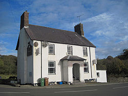
Penrhyn Arms
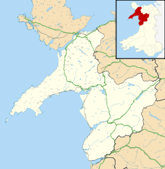
 Sarn Meyllteyrn shown within Gwynedd
OS grid reference SH2332 Community Botwnnog Principal area Gwynedd Ceremonial county Gwynedd Country Wales Sovereign state United Kingdom Post town PWLLHELI Postcode district LL53 Dialling code 01758 Police North Wales Fire North Wales Ambulance Welsh EU Parliament Wales UK Parliament Dwyfor Meirionnydd Welsh Assembly Dwyfor Meirionnydd List of places: UK • Wales • Gwynedd Sarn Meyllteyrn is a village and former civil parish (Known at the time as Mellteyrn) located to the West of the Llŷn Peninsula (Welsh: Penrhyn Llŷn) in the Welsh county of Gwynedd. It lies 8.4 miles (13.5 km) west of Pwllheli and 24.3 miles (39.2 km) south west of Caernarfon. The village is often referred to simply as Sarn. The parish was abolished in 1934, and divided between the communities of Botwnnog and Tudweiliog.[1]
Contents
History
Governance
For elections to Gwynedd Council, the village forms part of the electoral division of Botwnnog, Dwyfor, electing one councillor. Glyn Roberts of Plaid Cymru was elected in 2008.[2]
Geography
The river Soch runs through the village on its way to Abersoch. The village lies in a small valley with Mynydd Rhiw to the South, Mynydd Cefnamlwch to the North and Card Fadryn North-East.
Education
Primary education is provided by Ysgol Pont y Gôf, in the nearby village of Botwnnog. The school is in the Ysgol Botwnnog catchment area and this is where the majority of students will go on to complete Secondary education.[3]
Transport
Sarn Meyllteyrn lies on the B4413 between Llanbedrog and Aberdaron. Buses from Pwllheli to Aberdaron and Uwchmynydd serve the village and are operated by Nefyn Coaches and Arriva Buses Wales.[4][5] The nearest railway station is at Pwllheli.
References
- ^ A Vision of Britain Through Time : Mellteyrn Civil Parish Retrieved 13 January 2010
- ^ "Gwynedd Council election results for Botwnnog May 2008". Gwynedd Council. http://www.gwynedd.gov.uk/gwy_doc.asp?cat=5773&doc=20641. Retrieved 09 September 2011.
- ^ "Gwynedd Council School Catchment Areeas". http://www.gwynedd.gov.uk/upload/public/attachments/1102/RhestrYsgolion.pdf. Retrieved 09 September 2011.
- ^ "Bus Services: Aberdaron to Pwllheli". Gwynedd Council. http://www.gwynedd.gov.uk/upload/public/attachments/1078/17_17B_Aberdaron__Pwllheli__Aberdaron_Llun_i_SadMon_to_Fri.pdf. Retrieved 24 June 2011.
- ^ "Bus Services: Uwchmynydd to Pwllheli". Gwynedd Council. http://www.gwynedd.gov.uk/upload/public/attachments/1078/8B_Pwllhei__Rhydlios__Pwllheli_Llun_i_GwenMon_to_Fri.pdf. Retrieved 24 June 2011.
Gwynedd Principal settlements Bala • Bangor • Barmouth • Bethesda • Blaenau Ffestiniog • Caernarfon • Criccieth • Dolgellau • Ffestiniog • Harlech • Nefyn • Porthmadog • Pwllheli • Tywyn
Towns and villages Aberangell • Aberdaron • Aberdesach • Aberdyfi • Abererch • Abergeirw • Abergwyngregyn • Abergynolwyn • Aberllefenni • Abersoch • Abertrinant • Afon Wen • Anelog • Arthog • Beddgelert • Bethania • Bethel • Bethesda • Betws Garmon • Bodferin • Boduan • Bontddu • Bontnewydd • Botwnnog • Bryncroes • Bryn-crug • Brynrefail • Buan • Bwlch-derwin • Caeathro • Capel Celyn • Carmel • Carnguwch • Ceidio • Chwilog • Clwt-y-bont • Clynnog Fawr • Corris Uchaf • Corris • Croesor • Cwm y Glo • Deiniolen • Dinas • Dinas Dinlle • Dinas Mawddwy • Dinorwig • Dolbenmaen • Dolmelinllyn • Dwygyfylchi • Edern • Efailnewydd • Eisingrug • Fairbourne • Friog • Frongoch • Ganllwyd • Garndolbenmaen • Garneddwen • Gellilydan • Glasinfryn • Groeslon • Llan Ffestiniog • Llanaber • Llanaelhaearn • Llanarmon • Llanbedr • Llanbedrog • Llanberis • Llandanwg • Llandegwning • Llandeiniolen • Llandudwen • Llandwrog • Llandygai • Llanegryn • Llanelltyd • Llanengan • Llanfaelrhys • Llanfaglan • Llanfair • Llanfihangel Bachellaeth • Llanfihangel-y-Pennant • Llanfihangel-y-Pennant, Dolbenmaen • Llanfrothen • Llangelynnin • Llangian • Llangwnnadl • Llangybi • Llaniestyn • Llanigian • Llanllechid • Llanllyfni • Llannor • Llanrug • Llanuwchllyn • Llanwnda • Llanymawddwy • Llanystumdwy • Llithfaen • Llwyndyrys • Llwyngwril • Maentwrog • Mallwyd • Mellteyrn • Minffordd • Morfa Bychan • Morfa Nefyn • Mynydd Llandygai • Mynydd Nefyn • Mynytho • Nantlle Valley • Rhostryfan • Nantmor • Nasareth • Nebo • Pant Glas • Penffridd • Penisa'r Waun • Penllech • Penllyn • Penmaenpool • Pennal • Penrhos • Penrhyndeudraeth • Pentre Gwynfryn • Penygroes • Pen-y-meinl • Pistyll • Pontrug • Porthdinllaen • Portmeirion • Prenteg • Rachub • Rhiwddolion • Rhosgadfan • Rhoshirwaun • Rhoslefair • Rhos-y-gwaliau • Rhyd Ddu • Rhyd • Rhydyclafdy • Sarn Meyllteyrn • Soar • Talsarnau • Tal-y-bont (near Bangor) • Tal-y-bont (near Barmouth) • Talysarn • Tanygrisiau • Trawsfynydd • Trefor • Tregarth • Tremadog • Tudweiliog • Tywyn • Waunfawr • Y Felinheli • Y Ffor • Y Fron • Y RhiwUniversities and colleges Castles and forts Rivers Afon Artro • Afon Cwmnantcol • Afon Dwyryd • Afon Dysynni • Afon Fathew • Afon Glaslyn • Afon Llyfni • Afon Mawddach • Afon Rhythallt • Afon Seiont • Afon TrywerynIslands Categories:- Gwynedd geography stubs
- Villages in Gwynedd
Wikimedia Foundation. 2010.

