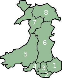
- Preserved counties of Wales
-
Preserved counties (Wales) 
Category Lieutenancy areas Location Wales Created by Local Government (Wales) Act 1994 (c. 19) Created 1 April 1996 Number 8 (as of 2008) The preserved counties of Wales are the current areas used in Wales for the ceremonial purposes of Lieutenancy and Shrievalty. They are based on the counties created by the Local Government Act 1972 and used for local government and other purposes between 1974 and 1996.
Contents
Usage
The Local Government (Wales) Act 1994 abolished the eight ceremonial counties created by the Local Government Act 1972. However, it created the concept of preserved counties based on their areas, to be used for purposes such as Lieutenancy. This usage was consolidated by the Lieutenancies Act 1997[1]
Certain statutes already in force were amended to include reference to them — as of 16 February 2011, the only remaining provisions still extant are:[2]
- The Sheriffs Act 1887 (c. 55) – the counties that High Sheriffs are appointed to are the preserved counties.
- The Defence Act 1842 (c. 94) – Lieutenants are those appointed to preserved counties.
- The Sea Fisheries (Shellfish) Act 1967 (c. 83) – relevant portions of the sea shore shall be deemed to be within preserved counties.
Boundary changes
The preserved counties were originally almost identical to the 1974–96 counties, but with a few minor changes in line with local government boundary changes: Llanrhaeadr-ym-Mochnant, Llansilin and Llangedwyn were transferred from Clwyd to Powys, and Wick, St Brides Major, Ewenny and Pentyrch were transferred from Mid Glamorgan to South Glamorgan. There were however two county boroughs, Conwy and Caerphilly split between preserved counties.
The Local Government Boundary Commission for Wales were instructed by the National Assembly for Wales on 11 March 2002 to undertake a review of preserved county boundaries. In their final proposals the part of the local government area of Conwy which had been in Gwynedd was to be part of Clwyd, and the part of the local government area of Caerphilly which had been in Mid Glamorgan was to be part of Gwent. The boundary between Mid Glamorgan and South Glamorgan was also to be re-aligned to reflect small changes in local government boundaries.[2] The Assembly accepted these proposals such that from 2 April 2003 each preserved county now encompasses between one and five whole local government areas.[3]
The boundary between Mid Glamorgan and Powys was further modified on 1 April 2010 to reflect the 2009 local government boundary changes in the Vaynor area.[4]
List of Preserved Counties
The population figures are mid-year estimates for 2007 from the Office for National Statistics, grouping component unitary authority area figures into their respective preserved counties.[5]
Name Comprises Area (km²) Population Clwyd Conwy, Denbighshire, Flintshire, Wrexham 2,910 491,100 Dyfed Carmarthenshire, Ceredigion, Pembrokeshire 5,780 375,200 Gwent Blaenau Gwent, Caerphilly, Monmouthshire, Newport, Torfaen 1,553 560,500 Gwynedd Gwynedd, Isle of Anglesey 3,262 187,400 Mid Glamorgan Bridgend, Merthyr Tydfil, Rhondda Cynon Taf 781 423,200 Powys Powys 5,196 132,000 South Glamorgan Cardiff, Vale of Glamorgan 475 445,000 West Glamorgan Neath Port Talbot, Swansea 820 365,500 See also
References
- ^ "23", Lieutenancies Act, UK: OPSI, 1997, http://www.opsi.gov.uk/acts/acts1997/1997023.htm.
- ^ a b Review of Preserved County Boundaries Final Proposals, UK: Local Government Boundary Commission for Wales, http://www.lgbc-wales.gov.uk/preserved/preserved_final_proposals_e.htm.
- ^ "Preserved Counties (Amendment to Boundaries) (Wales) Order", Legislation, UK: OPSI, 2003, http://www.opsi.gov.uk/legislation/wales/wsi2003/20030974e.htm.
- ^ The Preserved Counties of Powys and Mid Glamorgan (Changes in Area) Order 2010
- ^ Statistics.gov.uk
Preserved counties of Wales Clwyd • Dyfed • Gwent • Gwynedd • Mid Glamorgan • Powys • South Glamorgan • West Glamorgan
 Administrative geography of the United Kingdom
United Kingdom • Local government • History England • Local government • History Subdivisions: Regions • Ceremonial counties • Metropolitan and non-metropolitan counties • Unitary authorities • Districts (list) • Civil parishes (list)Northern Ireland • Local government • History Subdivisions: Counties • DistrictsScotland • Local government • History Wales • Local government • History Categories:- Preserved counties of Wales
- Lists of Welsh counties
Wikimedia Foundation. 2010.
