- Chwilog
-
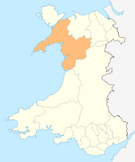
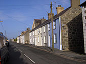
Chwilog is a village in Eifionydd on the Llyn Peninsula in the Welsh county of Gwynedd. It forms part of the community of Llanystumdwy.
The village is fairly linear, built up around the B4354 which crosses the peninsula to Boduan. The Afon Wen flows through the lower part of the village on its way to the sea at Afonwen, less than 1 mile (1.6 km) away.
Nearby is Lôn Goed, a wide tree-lined avenue created in the 18th century for transporting lime from the coast to the upland farms of Eifionydd. The track is no longer used for this purpose but is now popular with walkers.
Amenities
Chwilog Primary School was opened in 1908 by Margaret Lloyd George, wife of David Lloyd George. The village was built around the railway station on the Caernarfonshire Railway Line situated at the centre of the village. Businesses in the village include a butcher's shop and a tractor company. There is also a post office and a pub, the Madryn Arms.
External links
Gwynedd Principal settlements Bala • Bangor • Barmouth • Bethesda • Blaenau Ffestiniog • Caernarfon • Criccieth • Dolgellau • Ffestiniog • Porthmadog • Pwllheli • Tywyn
Towns and villages Aberangell • Aberdaron • Aberdesach • Aberdyfi • Abererch • Abergeirw • Abergwyngregyn • Abergynolwyn • Aberllefenni • Abersoch • Abertrinant • Afon Wen • Anelog • Arthog • Beddgelert • Bethania • Bethel • Bethesda • Betws Garmon • Bodferin • Boduan • Bontddu • Bontnewydd • Botwnnog • Bryncroes • Bryn-crug • Brynrefail • Buan • Bwlch-derwin • Caeathro • Capel Celyn • Carmel • Carnguwch • Ceidio • Chwilog • Clwt-y-bont • Clynnog Fawr • Corris Uchaf • Corris • Croesor • Cwm y Glo • Deiniolen • Dinas • Dinas Dinlle • Dinas Mawddwy • Dinorwig • Dolbenmaen • Dolmelinllyn • Dwygyfylchi • Edern • Efailnewydd • Eisingrug • Fairbourne • Friog • Frongoch • Ganllwyd • Garndolbenmaen • Garneddwen • Gellilydan • Glasinfryn • Groeslon • Harlech • Llan Ffestiniog • Llanaber • Llanaelhaearn • Llanarmon • Llanbedr • Llanbedrog • Llanberis • Llandanwg • Llandegwning • Llandeiniolen • Llandudwen • Llandwrog • Llandygai • Llanegryn • Llanelltyd • Llanengan • Llanfaelrhys • Llanfaglan • Llanfair • Llanfihangel Bachellaeth • Llanfihangel-y-Pennant • Llanfihangel-y-Pennant, Dolbenmaen • Llanfrothen • Llangelynnin • Llangian • Llangwnnadl • Llangybi • Llaniestyn • Llanigian • Llanllechid • Llanllyfni • Llannor • Llanrug • Llanuwchllyn • Llanwnda • Llanymawddwy • Llanystumdwy • Llithfaen • Llwyndyrys • Llwyngwril • Maentwrog • Mallwyd • Mellteyrn • Minffordd • Morfa Bychan • Morfa Nefyn • Mynydd Llandygai • Mynydd Nefyn • Mynytho • Nantlle Valley • Rhostryfan • Nantmor • Nasareth • Nebo • Nefyn • Pant Glas • Penffridd • Penisa'r Waun • Penllech • Penllyn • Penmaenpool • Pennal • Penrhos • Penrhyndeudraeth • Pentre Gwynfryn • Penygroes • Pen-y-meinl • Pistyll • Pontrug • Porthdinllaen • Portmeirion • Prenteg • Rachub • Rhiwddolion • Rhosgadfan • Rhoshirwaun • Rhoslefair • Rhos-y-gwaliau • Rhyd Ddu • Rhyd • Rhydyclafdy • Sarn Meyllteyrn • Soar • Talsarnau • Tal-y-bont (near Bangor) • Tal-y-bont (near Barmouth) • Talysarn • Tanygrisiau • Trawsfynydd • Trefor • Tregarth • Tremadog • Tudweiliog • Tywyn • Waunfawr • Y Felinheli • Y Ffor • Y Fron • Y RhiwUniversities and colleges Castles and forts Rivers Afon Artro • Afon Cwmnantcol • Afon Dwyryd • Afon Dysynni • Afon Fathew • Afon Glaslyn • Afon Llyfni • Afon Mawddach • Afon Rhythallt • Afon Seiont • Afon TrywerynIslands Coordinates: 52°55′11″N 4°19′49″W / 52.91972°N 4.33028°W
Categories:- Villages in Gwynedd
- Gwynedd geography stubs
Wikimedia Foundation. 2010.

