- River Sheppey
Geobox River
name = River Sheppey
native_name =
other_name =
other_name1 =
image_size =
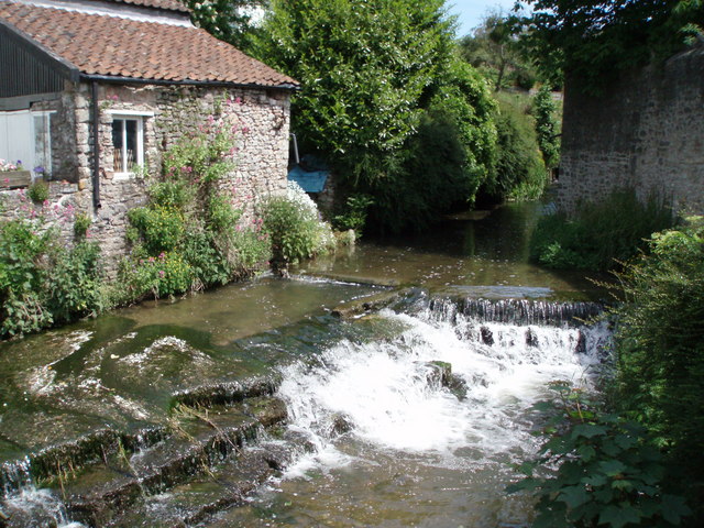
image_caption = River Sheppey atCroscombe
etymology =
country = England
country1 =
state = Somerset
state_type = County
state1 =
region =
region1 =
district =
district1 =
city =Shepton Mallet
city1 =
landmark =
landmark1 =
length_imperial =
watershed_imperial =
discharge_location =
discharge_imperial =
discharge_max_imperial =
discharge_min_imperial =
discharge1_location =
discharge1_imperial =
source_name =St Aldhelm's Well
source_location =Doulting
source_district = Mendip
source_region =
source_state = Somerset
source_country = England
source_lat_d = 51
source_lat_m = 11
source_lat_s = 13
source_lat_NS = N
source_long_d = 2
source_long_m = 30
source_long_s = 31
source_long_EW = W
source_elevation_imperial =
source_length_imperial =
mouth_name =River Brue
mouth_location = near Westhay
mouth_district = Mendip
mouth_region =
mouth_state = Somerset
mouth_country = England
mouth_lat_d = 51
mouth_lat_m = 10
mouth_lat_s = 44
mouth_lat_NS = N
mouth_long_d = 2
mouth_long_m = 47
mouth_long_s = 41
mouth_long_EW = W
mouth_elevation_imperial =
tributary_left =
tributary_left1 =
tributary_right =
tributary_right1 =
free_name =
free_value =
map_size =
map_caption =The River Sheppey has its source in a group of springs west of the village of
Doulting , nearShepton Mallet inSomerset ,England . It flows through the wetlands to the north of thePolden Hills and ultimately joins theRiver Brue .Route
From Doulting the Sheppey flows south west to Charlton, where parts of its course have been culverted. The river has been diverted underground for much, though not all, of its passage through Shepton Mallet.cite web |url=http://www.somerset.gov.uk/somerset/cultureheritage/heritage/info/somersetlandscape/somersettopographyrivers2.cfm |title=Somerset Topography: Rivers |accessdate=2008-01-03 |format= |work=Somerset County Council ] It reappears at Darshill and then flows south west through
Croscombe toDinder where it flows through the grounds ofDinder House which was built in 1801 and under a bridge which pre-dates the house. [cite web | title=Bridge over River Sheppey in grounds of Dinder House | work=Images of England | url=http://www.imagesofengland.org.uk/search/details.aspx?id=268066 | accessdate=2007-09-20] It then continues west pastDulcote , Woodford andCoxley .From Coxley the river flows north through Hay Moor and
North Moor , west through Ash Moor, then sharply south through Frogmore and west throughGodney . [Using Google Earth to view the Sheppey at Godney, the original course of the river can be clearly seen winding through the fields and intersecting the current river near the Old School.]At Lower Godney the river is channelled through the James Wear River and the Decoy Rhine to Westhay Level where it joins Whites River and then the River Brue near
Westhay .Ecology
The water quality is generally good however there have been some discharges from sewage treatment works in the area that can contribute to nutrient levels in rivers. Signs of nutrient enrichment are noticeable at times of low flow and the ecology of the Sheppey is adversely affected in its upper reaches. [cite web | url= http://publications.environment-agency.gov.uk/pdf/GESW0506BKVI-e-e.pdf | title= The Brue, Axe and North Somerset Streams Catchment Abstraction Management Strategy | accessdate=2008-01-03 | format= PDF | work=
Environment Agency | date= May 2006]History
It would appear that the Sheppey was only so-called in the late 19th century. Prior to then, if it was called anything, it was probably Doulting Water or the River Brae. [cite book |title=Shepton Mallet: A Visible History |last= Stone | first= Alan |year=2005 |publisher=Shepton Mallet Local History Group |isbn=0-9548125-1-4 ]
The Sheppey has been used in the past to power local industry, for example corn and textile mills in the Shepton Mallet area. [cite web |url=http://www.mendip.gov.uk/Documents/MinutesAndReports/Meetings%202004/Shepton%20Mallet%20&%20Wells%20Area%20Board/13.07.04/Agenda%20Item%2016%20-%20appendix%201.doc |title=The Inclusion of the Anglo Bavarian Brewery area In the Shepton Mallet Conservation Area
accessdate=2008-01-03 |format=Microsoft Word |work=Mendip District Council | date= June 2004 ] There may have been more than thirty mills powered by the river and its tributaries in the area of Shepton Mallet,Bowlish and Darshill, although fewer than this number of sites have been positively identified. ["Shepton Mallet: A Visible History", ibid]References
Wikimedia Foundation. 2010.