- National Register of Historic Places listings in New Bedford, Massachusetts
-
List of Registered Historic Places in New Bedford, Massachusetts, which has been transferred from and is an integral part of List of Registered Historic Places in Bristol County, Massachusetts
Contents: Counties in Massachusetts -
- This National Park Service list is complete through NPS recent listings posted November 4, 2011.[1]
[2] Landmark name[3] Image Date listed Location Summary 1 Acushnet Heights Historic District December 1, 1989 Roughly bounded by Summer, Weld, Purchase, Pope, County, and Robeson
41°38′52″N 70°55′53″W / 41.64778°N 70.93139°W2 Butler Flats Light 
June 15, 1987 New Bedford Channel
41°36′7″N 70°53′54″W / 41.60194°N 70.89833°W3 Buttonwood Park Historic District August 24, 2000 Kempton St., Rockdale Ave., Hawthorne St., and Brownell Ave.
41°37′55″N 70°57′7″W / 41.63194°N 70.95194°W4 Sgt. William H. Carney House April 21, 1975 128 Mill St.
41°38′15″N 70°55′59″W / 41.6375°N 70.93306°W5 Central New Bedford Historic District 
April 24, 1980 Roughly bounded by Acushnet Ave. and School, Middle, and 6th Sts.
41°38′6″N 70°55′39″W / 41.635°N 70.9275°W6 County Street Historic District 
August 11, 1976 Roughly bounded by Acushnet, Page, Middle, and Bedford Sts. (both sides)
41°37′55″N 70°55′55″W / 41.63194°N 70.93194°W7 Dawson Building September 30, 1982 1851 Purchase St.
41°39′0″N 70°55′48″W / 41.65°N 70.93°W8 Thomas Donaghy School March 2, 1989 68 South St.
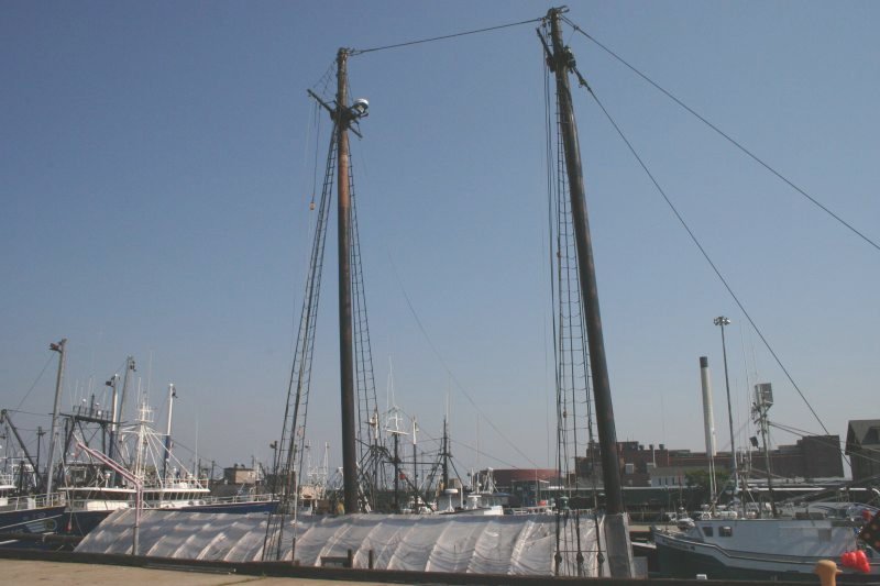
41°37′33″N 70°55′25″W / 41.62583°N 70.92361°W9 ERNESTINA (schooner) 
January 3, 1985 Steamship Wharf
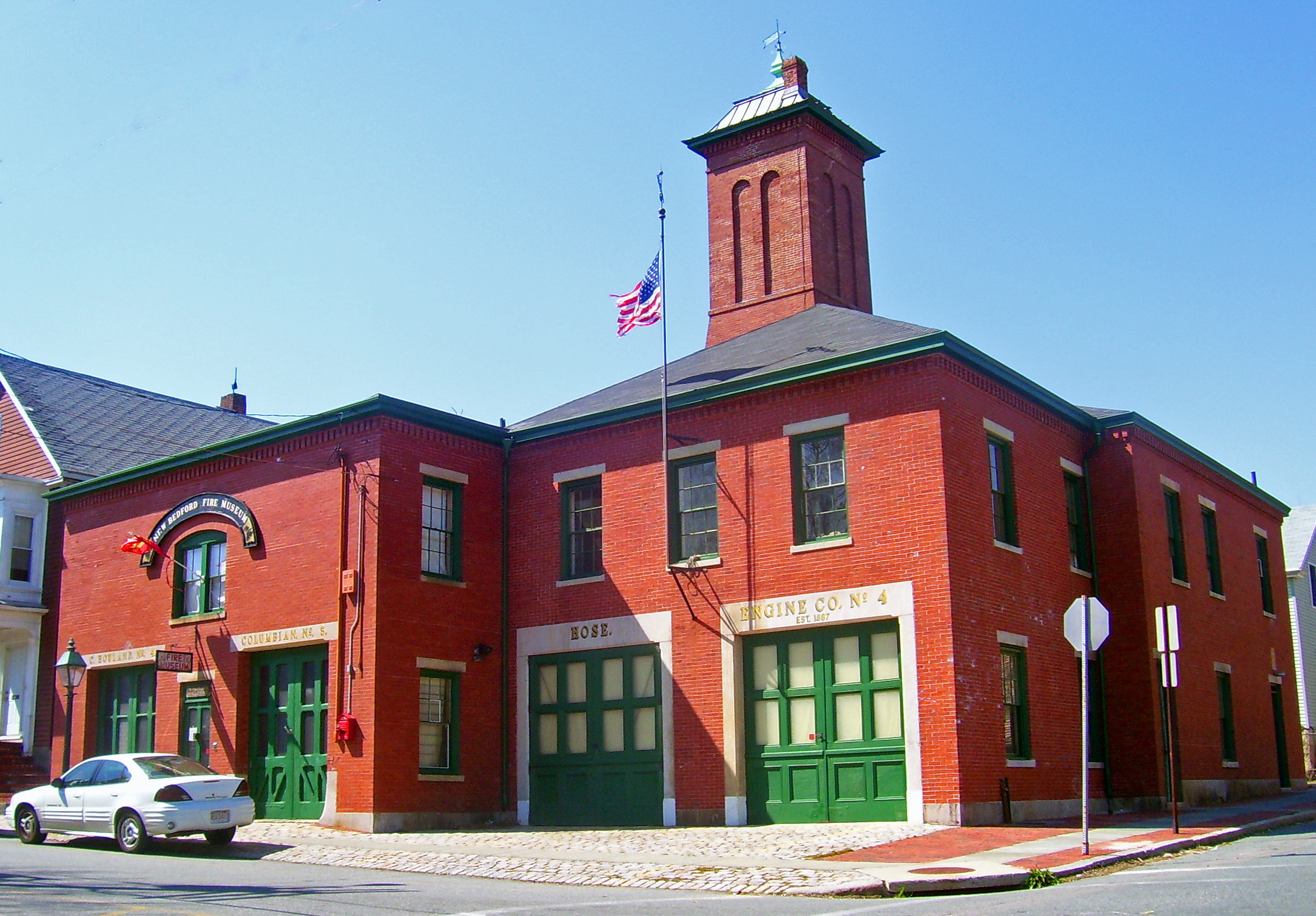
41°38′1″N 70°55′16″W / 41.63361°N 70.92111°WNational Historic Landmark 10 Fire Station No. 4 
July 24, 1975 79 S. 6th St.
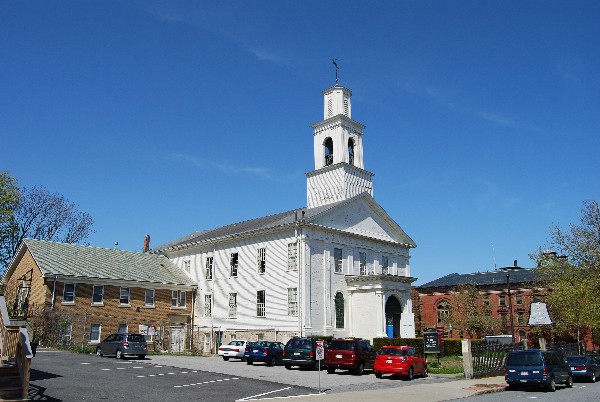
41°37′41″N 70°55′38″W / 41.62806°N 70.92722°W1867 building was oldest fire station in state when closed; now home of New Bedford Fire Museum 11 First Baptist Church 
April 21, 1975 149 William St.
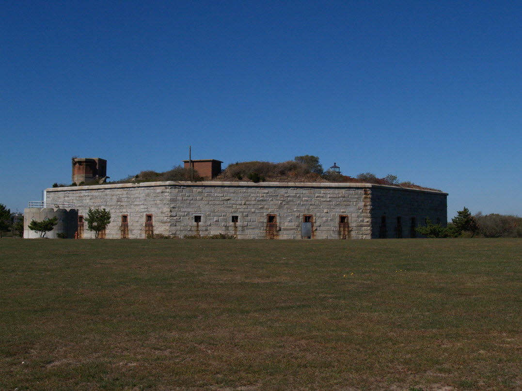
41°38′6″N 70°55′44″W / 41.635°N 70.92889°W12 Fort Taber District 
February 8, 1973 Wharf Rd. within Fort Rodman Military Reservation
41°35′36″N 70°54′14″W / 41.59333°N 70.90389°W13 Hazelwood Park June 24, 2010 597-603 Brock Ave.
41°36′24″N 70°54′48″W / 41.60667°N 70.91333°W14 Head of the River Historic District December 2, 2009 2-28 Main St., Acushnet; 2-28 Mill Rd., 2-13 Tarkiln Hill Rd.
41°40′54.25″N 70°55′9.07″W / 41.6817361°N 70.9191861°W15 Hotel Waverly January 26, 1990 1162-1166 Acushnet Ave.
41°39′26″N 70°55′38″W / 41.65722°N 70.92722°W16 Howland Mill Village Historic District May 30, 1996 Roughly bounded by Bolton, Winsper, Hemlock Sts., and Rockdale Ave.
41°36′58″N 70°56′0″W / 41.61611°N 70.933333°W17 Robert C. Ingraham School March 2, 2010 80 Rivet St.
41°37′14.16″N 70°55′20.28″W / 41.6206°N 70.9223°W18 Nathan and Mary Johnson Properties 
February 16, 2000 17-19 and 21 7th Street
41°37′59″N 70°55′44″W / 41.63306°N 70.92889°WNational Historic Landmark; home and meetinghouse of African-American abolitionist couple who took in Frederick Douglass after he escaped from slavery 19 Lightship No. 114 May 30, 1990 State Pier
41°38′8″N 70°55′16″W / 41.63556°N 70.92111°W20 Merrill's Wharf Historic District November 11, 1977 MacArthur Dr.
41°37′59″N 70°55′15″W / 41.63306°N 70.92083°W21 Moreland Terrace Historic District June 3, 1996 Roughly bounded by Moreland Terrace, Ash, Bedford, and Page Sts.
41°37′40″N 70°56′11″W / 41.62778°N 70.93639°W22 New Bedford Gas and Edison Light Complex June 3, 2002 180 MacAuthur Dr.
41°37′49″N 70°55′16″W / 41.63028°N 70.92111°W23 New Bedford Historic District 
November 13, 1966 Bounded by Front St. on the east, Elm St. on the north, Acushnet Ave. on the west, and Commercial St. on the south
41°38′7″N 70°55′27″W / 41.63528°N 70.92417°WNational Historic Landmark 24 New Bedford Whaling National Historical Park 
November 12, 1996 33 William St.
41°38′8.49″N 70°55′26.63″W / 41.6356917°N 70.9240639°W25 North Bedford Historic District September 19, 1979 Roughly bounded by Summer, Park, Pleasant, and Kempton Sts.
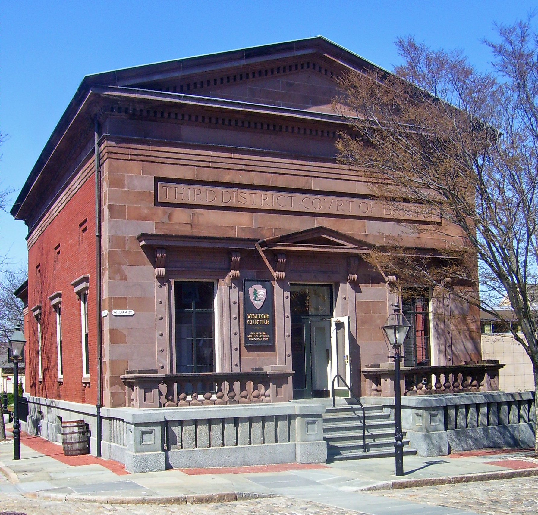
41°38′25″N 70°55′49″W / 41.64028°N 70.93028°W26 Old Third District Courthouse 
September 28, 1971 2nd and William Sts.
41°38′9″N 70°55′29″W / 41.63583°N 70.92472°W27 Palmer Island Light Station 
March 26, 1980 New Bedford Harbor
41°37′34″N 70°54′35″W / 41.62611°N 70.90972°WARLHS USA-578 28 William J. Rotch Gothic Cottage 
February 17, 2006 19 Irving St.
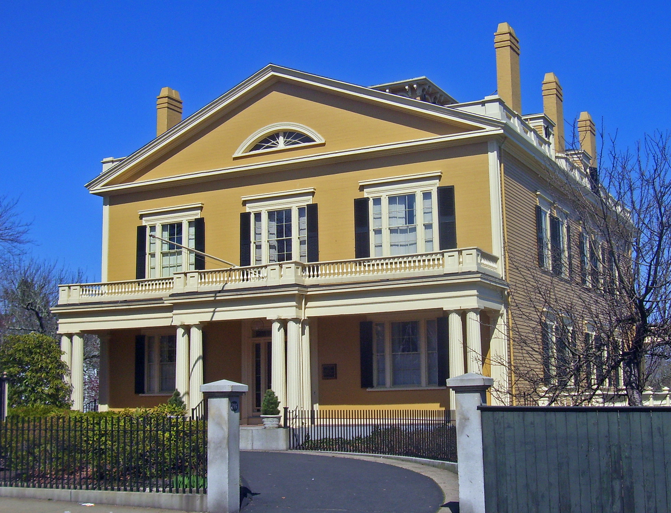
41°37′49.78″N 70°55′54.52″W / 41.6304944°N 70.9318111°WNational Historic Landmark 29 William Rotch, Jr. House 
April 5, 2005 396 County Street
41°37′49.07″N 70°55′43.27″W / 41.6302972°N 70.9286861°WNational Historic Landmark
Early Richard Upjohn house for prominent whaling family30 Shawmut Diner November 28, 2003 943 Shawmut Ave.
41°39′32″N 70°56′51″W / 41.65889°N 70.9475°W31 Bradford Smith Building May 17, 1984 1927-1941 Purchase St.
41°39′4″N 70°55′49″W / 41.65111°N 70.93028°W32 Thompson Street School January 26, 1990 58 Crapo St.
41°37′17″N 70°55′37″W / 41.62139°N 70.92694°W33 Times and Olympia Buildings July 7, 1983 908-912 and 880-898 Purchase St.
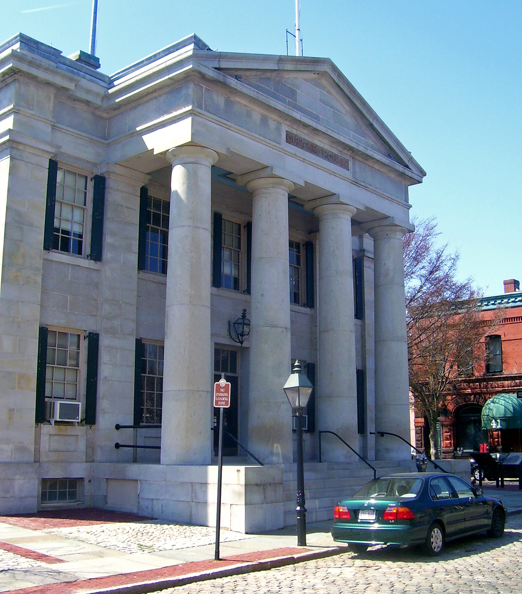
41°38′11″N 70°55′36″W / 41.63639°N 70.92667°W34 U.S. Customhouse 
December 30, 1970 Southwestern corner of 2nd and Williams Sts.
41°38′7″N 70°55′29″W / 41.63528°N 70.92472°WOldest U.S. Customs facility in continuous use; Greek Revival public building by Robert Mills 35 Union Baptist Church June 16, 2008 109 Court St.
41°38′3.05″N 70°56′5.19″W / 41.6341806°N 70.934775°W36 Union Street Railway Carbarn, Repair Shop October 2, 1978 1959 Purchase St.
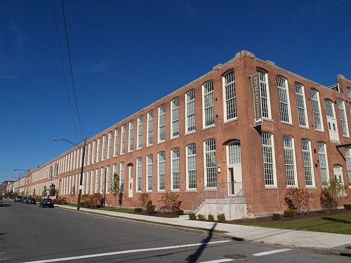
41°39′7″N 70°55′52″W / 41.65194°N 70.93111°W37 Wamsutta Mills 
August 19, 2008 Acushnet Ave., Logan, Wamsutta, and N. Front St.
41°39′5.3244″N 70°55′39.4572″W / 41.651479°N 70.927627°W38 Whitman Mills 
August 29, 2003 1, 90, and the eastern side of Riverside Ave., rear 1 and the southern and northern sides of Coffin Ave., and 10 Manomet St.
41°39′45″N 70°55′10″W / 41.6625°N 70.91944°W(#83004613) More Info See also
References
- ^ "National Register of Historic Places: Weekly List Actions". National Park Service, United States Department of the Interior. Retrieved on November 4, 2011.
- ^ Numbers represent an ordering by significant words. Various colorings, defined here, differentiate National Historic Landmark sites and National Register of Historic Places Districts from other NRHP buildings, structures, sites or objects.
- ^ "National Register Information System". National Register of Historic Places. National Park Service. 2008-04-24. http://nrhp.focus.nps.gov/natreg/docs/All_Data.html.
U.S. National Register of Historic Places Topics Lists by states Alabama • Alaska • Arizona • Arkansas • California • Colorado • Connecticut • Delaware • Florida • Georgia • Hawaii • Idaho • Illinois • Indiana • Iowa • Kansas • Kentucky • Louisiana • Maine • Maryland • Massachusetts • Michigan • Minnesota • Mississippi • Missouri • Montana • Nebraska • Nevada • New Hampshire • New Jersey • New Mexico • New York • North Carolina • North Dakota • Ohio • Oklahoma • Oregon • Pennsylvania • Rhode Island • South Carolina • South Dakota • Tennessee • Texas • Utah • Vermont • Virginia • Washington • West Virginia • Wisconsin • WyomingLists by territories Lists by associated states Other  Category:National Register of Historic Places •
  Portal:National Register of Historic PlacesCategories:
- New Bedford, Massachusetts
- Lists of National Register of Historic Places listings in Massachusetts by populated place
-


Wikimedia Foundation. 2010.