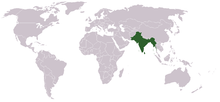
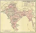
- Presidencies and provinces of British India
-
"British India" redirects here. For the history of the British Empire in India, see British Raj. For other uses, see British India (disambiguation).
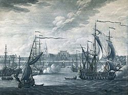 A Mezzotint engraving of Fort William, Calcutta, which formed the Bengal Presidency in British India 1735.
Provinces of India, earlier Presidencies of British India, still earlier, Presidency towns, and collectively British India, were the administrative units of the territories of India under the tenancy or the sovereignty of either the East India Company or the British Crown between 1612 and 1947.
British India is divided into three periods. From the early 17th century to the middle of the 18th century, the East India Company traded in Bengal on the sufferance of the native powers. Its rivals were the merchant trading companies of Holland and France. In the next hundred years, referred to as Company rule in India, the Company acquired paramountcy, but increasingly shared its sovereignty with the Crown, gradually losing its mercantile privileges. Following the Sepoy Mutiny of 1857, the Company's remaining powers were transferred to the Crown initiating the direct rule by the British Empire (1858–1947). The term "British India" has also been used secondarily as a shortened form for "the British people in the British Empire in India."[1]
Contents
British India
Colonial India 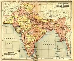
British Indian EmpireColonial India Portuguese India 1510–1961 Dutch India 1605–1825 Danish India 1620–1869 French India 1759–1954 British India 1613–1947 East India Company 1612–1757 Company rule in India 1757–1857 British Raj 1858–1947 British rule in Burma 1824–1942 Princely states 1765–1947/48 Partition of India 1947 In 1608 the English East India Company established a settlement at Surat (now in the state of Gujarat), and this became the company's first headquarters town. It was followed in 1611 by a permanent factory at Machilipatnam on the Coromandel Coast, and in 1612 the company joined other European trading companies in Bengal.[2] However, following the decline of the Mughal Empire in 1707 and after the East India Company's victory at the Battle of Plassey in 1757 and Battle of Buxar, both in Bengal 1764, the Company gradually began to formally expand its dominions and collectively call the area India.[3] By the mid-19th century, the East India Company had become the paramount political and military power on the subcontinent, its territory held in trust for the British Crown.[4]
Company rule in India, however, ended with the Government of India Act 1858 following the events of the Indian rebellion of 1857.[4] British India was thereafter directly ruled by the British Crown as a colonial possession of the United Kingdom, and India was officially known after 1876 as the Empire of India.[5] India consisted of regions referred to as British India that were directly administered by the British,[6] and other regions, the Princely States,[7] that were ruled by Indian rulers. These rulers were allowed a measure of internal autonomy in exchange for British suzerainty. British India constituted a significant portion of India both in area and population; in 1910, for example, it covered approximately 54% of the area and included over 77% of the population.[8] In addition, there were Portuguese and French exclaves in India. Independence from British rule was achieved in 1947 with the formation of the Dominions of India and Pakistan, the latter also including present-day Bangladesh.
The term British India also applied to Burma for a shorter time period: starting in 1824, a small part of Burma, and by 1886, almost two thirds of Burma had come under British India.[6] This arrangement lasted until 1937, when Burma commenced being administered as a separate British colony. British India did not apply to other countries in the region, such as Sri Lanka (then Ceylon), which was a British Crown Colony, or the Maldive Islands, which were a British protectorate. At its greatest extent, in the early 20th-century, the territory of British India extended as far as the frontiers of Persia in the west; Afghanistan in the northwest; Tibet in the northeast; and China, French Indo-China and Siam in the east. It also included the Colony of Aden in the Arabian Peninsula.[9]
Presidency towns (1600–1765)
-
India in 1700 showing the Mughal Empire and the European trading settlements.
- Madras Presidency: established 1640.
- Bombay Presidency: East India Company's headquarters moved from Surat to Bombay (Mumbai) in 1687.
- Bengal Presidency: established 1690.
The East India Company, which was incorporated on December 31, 1600, established trade relations with Indian rulers in Masulipatam on the east coast in 1611 and Surat on the west coast in 1612.[10] The company rented a trading outpost in Madras in 1639.[10][10] Bombay, which was ceded to the British Crown by Portugal as part of the wedding dowry of Catherine of Braganza in 1661, was in turn granted to the East India Company to be held in trust for the Crown.[10]
Meanwhile, in eastern India, after obtaining permission from the Mughal Emperor Shah Jahan to trade with Bengal, the Company established its first factory at Hoogly in 1640.[10] Almost a half-century later, after Emperor Aurengzeb forced the Company out of Hooghly, Calcutta was founded by Job Charnock in 1686.[10] By the mid-18th century the three principal trading settlements, now called the Madras Presidency (or the Presidency of Fort St. George), the Bombay Presidency, and the Bengal Presidency (or the Presidency of Fort William) were each administered by a Governor.[11]
Presidencies of British India (1772–1858)
After Robert Clive's victory in the Battle of Plassey in 1757, the puppet government of a new Nawab of Bengal, was maintained by the East India Company.[12] However, after the invasion of Bengal by the Nawab of Oudh in 1764 and his subsequent defeat in the Battle of Buxar, the Company obtained the Diwani of Bengal, which included the right to administer and collect land-revenue (land tax) in Bengal, the region of present-day Bangladesh, West Bengal and Bihar.[12] In 1772, the Company also obtained the Nizāmat of Bengal (the "exercise of criminal jurisdiction") and thereby full sovereignty of the expanded Bengal Presidency.[12] During the period, 1773 to 1785, very little changed; the only exceptions were the addition of the dominions of the Raja of Banares to the western boundary of the Bengal Presidency, and the addition of Salsette Island to the Bombay Presidency.[13]
Portions of the Kingdom of Mysore were annexed to the Madras Presidency after the Third Anglo-Mysore War ended in 1792. Next, in 1799, after the defeat of Tipu Sultan in the Fourth Anglo-Mysore War more of his territory was annexed to the Madras Presidency.[13] In 1801, Carnatic, which had been under the suzerainty of the Company, began to be directly administered by it as a part of the Madras Presidency.[14]
-
North-Western Provinces, constituted in 1836 from erstwhile Ceded and Conquered Provinces
-
Punjab annexed in 1849
- Madras Presidency: Expanded in the mid-to-late 18th century Carnatic Wars and Anglo-Mysore Wars.
- Bombay Presidency: expanded after the Anglo-Maratha Wars.
- Bengal Presidency: Expanded after the battles of Plassey (1757) and Buxar (1764), and after the Second and Third Anglo-Maratha Wars.
- Ajmer-Merwara-Kekri: ceded by Sindhia of Gwalior in 1818 at the conclusion of the Third Anglo-Maratha War.
- Coorg: Annexed in 1834.
- Ceded and Conquered Provinces: Established in 1802 within the Bengal Presidency. Proposed to be renamed the Presidency of Agra under a Governor in 1835, but proposal not implemented.
- North-Western Provinces: established as a Lieutenant-Governorship in 1836 from the erstwhile Ceded and Conquered Provinces
- Sind annexed to the Bombay Presidency in 1843.
- Punjab: Established in 1849 from territories captured in the First and Second Anglo-Sikh Wars.
- Nagpur Province: Created in 1853 from the princely state of Nagpur, seized by the doctrine of lapse. Merged into the Central Provinces in 1861.
- Oudh annexed in 1856 and governed thereafter until 1905 as a Chief Commissionership, as a part of North-Western Provinces and Oudh.
Provinces of India (1858–1947)
-
The British Indian Empire in 1893, after the annexation of Upper Burma and incorporation of Baluchistan
-
A map of the British Indian Empire in 1907 during the partition of Bengal (1905–1912)
- Central Provinces: Created in 1861 from Nagpur Province and the Saugor and Nerbudda Territories. Berar administered since 1903, renamed the Central Provinces and Berar in 1936.
- Burma: Lower Burma annexed 1852, established as a province in 1862, Upper Burma incorporated in 1886. Separated from British India in 1937 to become administered independently by the newly established British Government Burma Office.
- Assam: separated from Bengal in 1874. Incorporated into new province of Eastern Bengal and Assam in 1905. Re-established as a province in 1912.
- Andaman and Nicobar Islands: established as a province in 1875.
- Baluchistan: Organized into a province in 1887.
-
1908 map of Central Provinces and Berar. Berar was included in 1903.
-
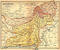
Beluchistan, shown as a part of the British Indian Empire in a 1908 map.
- North-West Frontier Province: created in 1901 from the north-western districts of Punjab Province.
- Eastern Bengal and Assam: created in 1905 upon partition of Bengal, together with the former province of Assam. Re-merged with Bengal in 1912, with north-eastern part re-established as the province of Assam.
- Bihar and Orissa: separated from Bengal in 1912. Renamed Bihar in 1936 when Orissa became a separate province.
- Delhi: Separated from Punjab in 1912, when it became the capital of British India.
- Aden: separated from Bombay Presidency to become province of India in 1932; separated from India and made the Crown Colony of Aden in 1937.
- Orissa: Separated from Bihar in 1936.
- Sind: Separated from Bombay in 1936.
- Panth-Piploda: made a province in 1942, from territories ceded by a native ruler.
Major provinces
 A map of the British Indian Empire in 1909 during the partition of Bengal (1905–1911), showing British India in two shades of pink (coral and pale) and the princely states in yellow.
At the turn of the 20th century, British India consisted of eight provinces that were administered either by a Governor or a Lieutenant-Governor. The following table lists their areas and populations (but does not include those of the dependent Native States):[15] During the partition of Bengal (1905–1912), a new Lieutenant-Governor's province of Eastern Bengal and Assam existed. In 1912, the partition was partially reversed, with the eastern and western halves of Bengal re-united and the province of Assam re-established; a new Lieutenant-Governor's province of Bihar and Orissa was also created.
Province of British India[15] Area (in thousands of square miles) Population (in millions of inhabitants) Chief Administrative Officer Burma 170 9 Lieutenant-Governor Bengal 151 75 Lieutenant-Governor Madras 142 38 Governor-in-Council Bombay 123 19 Governor-in-Council United Provinces 107 48 Lieutenant-Governor Central Provinces and Berar 104 13 Chief Commissioner Punjab 97 20 Lieutenant-Governor Assam 49 6 Chief Commissioner Minor provinces
In addition, there were a few minor provinces that were administered by a Chief Commissioner:[16]
Minor Province[16] Area (in thousands of square miles) Population (in thousands of inhabitants) Chief Administrative Officer North-West Frontier Province 16 2,125 Chief Commissioner British Baluchistan 46 308 British Political Agent in Baluchistan served as ex-officio Chief Commissioner Coorg 1.6 181 British Resident in Mysore served as ex-officio Chief Commissioner Ajmer-Merwara 2.7 477 British Political Agent in Rajputana served as ex-officio Chief Commissioner Andaman and Nicobar Islands 3 25 Chief Commissioner Provinces at independence, 1947
At independence in 1947, British India had seventeen provinces:
- Ajmer-Merwara-Kekri
- Andaman and Nicobar Islands
- Assam
- Baluchistan
- Bengal Province
- Bihar
- Bombay Province
- Central Provinces and Berar
- Coorg
- Delhi Province
- Madras Province
- North-West Frontier Province
- Panth-Piploda
- Orissa
- Punjab
- Sindh
- United Provinces of Agra and Oudh
Upon the Partition of India into Union of India and Dominion of Pakistan, twelve provinces (Ajmer-Merwara-Kekri, Andaman and Nicobar Islands, Assam, Bihar, Bombay, Central Provinces and Berar, Coorg, Delhi, Madras, Panth-Piploda, Orissa, and the United Provinces) became provinces within India, three (Baluchistan, North-West Frontier, and Sindh) within Pakistan, and two (Bengal and Punjab) were partitioned between India and Pakistan.
In 1950, after the new Indian Constitution was adopted, the provinces in India were replaced by redrawn states and union territories. Pakistan, however, retained its five provinces, one of which, East Bengal, was renamed East Pakistan in 1956 and became the independent nation of Bangladesh in 1971.
See also
- British Empire in India (for usage)
- Company rule in India (for the period 1757–1858)
- British Raj (for the period 1858–1947)
- East India Company (for the period 1612–1858)
- British rule in Burma
- Princely States
- Royal Indian Navy
Notes
- ^ Imperial Gazetteer of India vol. IV 1908, p. 5 Quote: "The history of British India falls ... into three periods. From the beginning of the seventeenth to the middle of the eighteenth century the East India Company is a trading corporation, existing on the sufferance of the native powers, and in rivalry with the merchant companies of Holland and France. During the next century the Company acquires and consolidates its dominion, shares its sovereignty in increasing proportions with the Crown, and gradually loses its mercantile privileges and functions. After the Mutiny of 1857, the remaining powers of the Company are transferred to the Crown ..." (p. 5)
- ^ Imperial Gazetteer of India vol. II 1908, pp. 452–472
- ^ Imperial Gazetteer of India vol. II 1908, pp. 473–487
- ^ a b Imperial Gazetteer of India vol. II 1908, pp. 488–514
- ^ Imperial Gazetteer of India vol. II 1908, pp. 514–530
- ^ a b Imperial Gazetteer of India vol. IV 1908, pp. 46–57
- ^ Imperial Gazetteer of India vol. IV 1908, pp. 58–103
- ^ Imperial Gazetteer of India vol. IV 1908, pp. 59–61
- ^ Imperial Gazetteer of India vol. IV 1908, pp. 104–125
- ^ a b c d e f Imperial Gazetteer of India vol. IV 1907, p. 6
- ^ Imperial Gazetteer of India vol. IV 1907, p. 7
- ^ a b c Imperial Gazetteer of India vol. IV 1907, p. 9
- ^ a b Imperial Gazetteer of India vol. IV 1907, p. 10
- ^ Imperial Gazetteer of India vol. IV 1907, p. 11
- ^ a b Imperial Gazetteer of India vol. IV 1907, p. 46
- ^ a b Imperial Gazetteer of India vol. IV 1907, p. 56
References
- Imperial Gazetteer of India vol. II (1908), The Indian Empire, Historical, Published under the authority of His Majesty's Secretary of State for India in Council, Oxford at the Clarendon Press. Pp. xxxv, 1 map, 573
- Imperial Gazetteer of India vol. III (1907), The Indian Empire, Economic (Chapter X: Famine, pp. 475–502), Published under the authority of His Majesty's Secretary of State for India in Council, Oxford at the Clarendon Press. Pp. xxxvi, 1 map, 520
- Imperial Gazetteer of India vol. IV (1907), The Indian Empire, Administrative, Published under the authority of His Majesty's Secretary of State for India in Council, Oxford at the Clarendon Press. Pp. xxx, 1 map, 552
Further reading
- Bandyopadhyay, Sekhar (2004), From Plassey to Partition: A History of Modern India, New Delhi and London: Orient Longmans. Pp. xx, 548., ISBN 8125025960
- Brown, Judith M. (1994), Modern India: The Origins of an Asian Democracy, Oxford and New York: Oxford University Press. Pp. xiii, 474, ISBN 0198731132
- Copland, Ian (2001), India 1885-1947: The Unmaking of an Empire (Seminar Studies in History Series), Harlow and London: Pearson Longmans. Pp. 160, ISBN 0582381738
- Harrington, Jack (2010), Sir John Malcolm and the Creation of British India, New York: Palgrave Macmillan., ISBN 978-0-230-10885-1
- Judd, Dennis (2004), The Lion and the Tiger: The Rise and Fall of the British Raj, 1600-1947, Oxford and New York: Oxford University Press. Pp. xiii, 280, ISBN 0192803581
- Majumdar, R. C.; Raychaudhuri, H. C.; Datta, Kalikinkar (1950), An Advanced History of India, London: Macmillan and Company Limited. 2nd edition. Pp. xiii, 1122, 7 maps, 5 coloured maps.
- Markovits, Claude (ed) (2005), A History of Modern India 1480-1950 (Anthem South Asian Studies), Anthem Press. Pp. 607, ISBN 1843311526
- Metcalf, Barbara; Metcalf, Thomas R. (2006), A Concise History of Modern India (Cambridge Concise Histories), Cambridge and New York: Cambridge University Press. Pp. xxxiii, 372, ISBN 0521682258.
- Peers, Douglas M. (2006), India under Colonial Rule 1700-1885, Harlow and London: Pearson Longmans. Pp. xvi, 163, ISBN 058231738
- Sarkar, Sumit (1983), Modern India: 1885-1947, Delhi: Macmillan India Ltd. Pp. xiv, 486, ISBN 0333904257
- Smith, Vincent A. (1921), India in the British Period: Being Part III of the Oxford History of India, Oxford: At the Clarendon Press. 2nd edition. Pp. xxiv, 316 (469-784)
- Spear, Percival (1990), A History of India, Volume 2: From the sixteenth century to the twentieth century, New Delhi and London: Penguin Books. Pp. 298, ISBN 0140138366
External links
- Mill, James (1820), The History of British India, in six volumes, London: Baldwin, Cradock, and Joy, 3rd edition, 1826, http://oll.libertyfund.org/?option=com_staticxt&staticfile=show.php%3Ftitle=1867
- Meyer, Sir W. S.; Burn, Sir R.; Cotton, J. S.; Risley, Sir H. H. (1908–1931: vol. 1, 1909), The Imperial Gazetteer of India (3rd edition), Oxford: Clarendon Press, http://dsal.uchicago.edu/reference/gazetteer/.
- Statistical abstracts relating to British India, from 1840 to 1920 at uchicago.edu
- Digital Colonial Documents (India) Homepage at latrobe.edu.au
- Provinces of British India at worldstatesmen.org
- Collection of early 20th century photographs of the cities of Bombay, Calcutta, and Madras with other interesting Indian locations from the magazine, India Illustrated, at the University of Houston Digital Library
- Coins of British India
British Empire and Commonwealth of Nations Legend
Current territory · Former territory
* now a Commonwealth realm · now a member of the Commonwealth of NationsEurope18th century
1708–1757 Minorca
since 1713 Gibraltar
1763–1782 Minorca
1798–1802 Minorca19th century
1800–1964 Malta
1807–1890 Heligoland
1809–1864 Ionian Islands20th century
1921-1937 Irish Free StateNorth America17th century
1583–1907 Newfoundland
1607–1776 Virginia
since 1619 Bermuda
1620–1691 Plymouth Colony
1629–1691 Massachusetts Bay Colony
1632–1776 Maryland
1636–1776 Connecticut
1636–1776 Rhode Island
1637–1662 New Haven Colony
1663–1712 Carolina
1664–1776 New York
1665–1674 and 1702-1776 New Jersey
1670–1870 Rupert's Land
1674–1702 East Jersey
1674–1702 West Jersey
1680–1776 New Hampshire
1681–1776 Pennsylvania
1686–1689 Dominion of New England
1691–1776 Massachusetts18th century
1701–1776 Delaware
1712–1776 North Carolina
1712–1776 South Carolina
1713–1867 Nova Scotia
1733–1776 Georgia
1763–1873 Prince Edward Island
1763–1791 Quebec
1763–1783 East Florida
1763–1783 West Florida
1784–1867 New Brunswick
1791–1841 Lower Canada
1791–1841 Upper Canada19th century
1818–1846 Columbia District / Oregon Country1
1841–1867 Province of Canada
1849–1866 Vancouver Island
1853–1863 Colony of the Queen Charlotte Islands
1858–1866 British Columbia
1859–1870 North-Western Territory
1862–1863 Stikine Territory
1866–1871 Vancouver Island and British Columbia
1867–1931 *Dominion of Canada2
20th century
1907–1949 Dominion of Newfoundland31Occupied jointly with the United States
2In 1931, Canada and other British dominions obtained self-government through the Statute of Westminster. see Canada's name.
3Gave up self-rule in 1934, but remained a de jure Dominion until it joined Canada in 1949.Latin America and the Caribbean17th century
1605–1979 *Saint Lucia
1623–1883 Saint Kitts (*Saint Kitts & Nevis)
1624–1966 *Barbados
1625–1650 Saint Croix
1627–1979 *St. Vincent and the Grenadines
1628–1883 Nevis (*Saint Kitts & Nevis)
1629–1641 St. Andrew and Providence Islands4
since 1632 Montserrat
1632–1860 Antigua (*Antigua & Barbuda)
1643–1860 Bay Islands
since 1650 Anguilla
1651–1667 Willoughbyland (Suriname)
1655–1850 Mosquito Coast (protectorate)
1655–1962 *Jamaica
since 1666 British Virgin Islands
since 1670 Cayman Islands
1670–1973 *Bahamas
1670–1688 St. Andrew and Providence Islands4
1671–1816 Leeward Islands
18th century
1762–1974 *Grenada
1763–1978 Dominica
since 1799 Turks and Caicos Islands19th century
1831–1966 British Guiana (Guyana)
1833–1960 Windward Islands
1833–1960 Leeward Islands
1860–1981 *Antigua and Barbuda
1871–1964 British Honduras (*Belize)
1882–1983 *Saint Kitts.2C 1623 to 1700|St. Kitts and Nevis
1889–1962 Trinidad and Tobago
20th century
1958–1962 West Indies Federation4Now the San Andrés y Providencia Department of Colombia
AfricaAsiaOceania18th century
1788–1901 New South Wales19th century
1803–1901 Van Diemen's Land/Tasmania
1807–1863 Auckland Islands7
1824–1980 New Hebrides (Vanuatu)
1824–1901 Queensland
1829–1901 Swan River Colony/Western Australia
1836–1901 South Australia
since 1838 Pitcairn Islands
1841–1907 Colony of New Zealand
1851–1901 Victoria
1874–1970 Fiji8
1877–1976 British Western Pacific Territories
1884–1949 Territory of Papua
1888–1965 Cook Islands7
1889–1948 Union Islands (Tokelau)7
1892–1979 Gilbert and Ellice Islands9
1893–1978 British Solomon Islands1020th century
1900–1970 Tonga (protected state)
1900–1974 Niue7
1901–1942 *Commonwealth of Australia
1907–1953 *Dominion of New Zealand
1919–1942 Nauru
1945–1968 Nauru
1919–1949 Territory of New Guinea
1949–1975 Territory of Papua and New Guinea117Now part of the *Realm of New Zealand
8Suspended member
9Now Kiribati and *Tuvalu
10Now the *Solomon Islands
11Now *Papua New GuineaAntarctica and South Atlantic17th century
since 1659 St. Helena1219th century
since 1815 Ascension Island12
since 1816 Tristan da Cunha12
since 1833 Falkland Islands1320th century
since 1908 British Antarctic Territory14
since 1908 South Georgia and the South Sandwich Islands13, 1412Since 2009 part of Saint Helena, Ascension and Tristan da Cunha; Ascension Island (1922—) and Tristan da Cunha (1938—) were previously dependencies of St Helena
13Occupied by Argentina during the Falklands War of April–June 1982
14Both claimed in 1908; territories formed in 1962 (British Antarctic Territory) and 1985 (South Georgia and the South Sandwich Islands)Categories:- Subdivisions of British India
- History of Pakistan
- Historical Indian regions
-
Wikimedia Foundation. 2010.

