- Santo Domingo
-
This article is about the city. For other uses, see Santo Domingo (disambiguation).
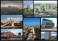
Santo Domingo — City — Santo Domingo de Guzmán Clockwise from the upper left: skyline of Santo Domingo; Fortaleza Ozama; Malecón Center; Supreme Court of Justice; Acrópolis Center; Anacaona Avenue; the Cathedral of Santa María; the National Palace. 
Coat of armsMotto: Ciudad Primada de América
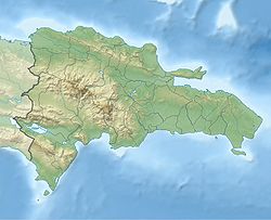
(First City of America)Santo Domingo in the Dominican Republic Coordinates: 18°30′0″N 69°59′0″W / 18.5°N 69.983333°WCoordinates: 18°30′0″N 69°59′0″W / 18.5°N 69.983333°W Country  Dominican Republic
Province National District Founded 1496 Founder Bartholomew Columbus Government - Mayor Roberto Salcedo Area[1] - Total 104.44 km2 (40.3 sq mi) Elevation[2] 14 m (46 ft) Population (2010) - Urban 2,552,398 - Metro 3,712,391 - Gentilic Capitaleño/a Postal Code(s) 10100 to 10699 Distrito Nacional, 10700 to 11999 Santo Domingo Website Ayuntamiento del Distrito Nacional Santo Domingo, known officially as Santo Domingo de Guzmán, is the capital and largest city in the Dominican Republic. Its metropolitan population was 2,084,852 in 2003, and estimated at 3,294,385 in 2010.[3] The city is located on the Caribbean Sea, at the mouth of the Ozama River. Founded by Bartholomew Columbus in 1496, it is the oldest continuously inhabited European settlement in the Americas, and was the first seat of Spanish colonial rule in the New World. It lies within the boundaries of the Distrito Nacional (D.N.; "National District"), itself bordered on three sides by Santo Domingo Province.
Santo Domingo was called "Ciudad Trujillo", from 1930 to 1961, after the Dominican Republic's dictator, Rafael Trujillo, named the capital after himself. Following his assassination, the city resumed its original designation. Today, Santo Domingo is the Dominican Republic's major metropolis, and is the largest city in the Caribbean by population.[citation needed] Santo Domingo is ranked as a Gamma world city by Loughborough University.
Please note: When this article refers to Santo Domingo it is most likely referring to the Greater Santo Domingo Area (Distrito Nacional plus Santo Domingo Province). In some cases it may state "D.N.", which strictly refers to the city proper, i.e., excluding the surrounding province of Santo Domingo.
Contents
History
See also: History of the Dominican Republic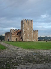 Fortaleza Ozama, one of the historic buildings in Santo Domingo
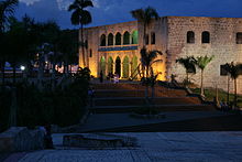 Alcázar de Colón, in the historic center of Santo Domingo's Zona Colonial
Before the arrival of Christopher Columbus in 1492, the Taíno people populated the island they called Quisqueya (mother of all lands) and Ayiti (land of high mountains), which Columbus named Hispaniola. It includes the part now occupied by the Republic of Haiti. At the time, the island's territory consisted of five chiefdoms: Marién, Maguá, Maguana, Jaragua, and Higüey. These were ruled respectively by caciques (chiefs) Guacanagarix, Guarionex, Caonabo, Bohechío, and Cayacoa.
Dating to 1496, when the Spanish settled there, and officially to 5 August 1498, Santo Domingo is the oldest European city in America. Bartholomew Columbus founded the settlement and named it La Nueva Isabela, after an earlier settlement in the north named after the Queen of Spain Isabella I. It was later[when?] renamed "Santo Domingo", in honor of Saint Dominic. Santo Domingo came to be known as the "Gateway to the Caribbean".
Santo Domingo was destroyed by a hurricane in 1502, and the new Governor Nicolás de Ovando had it rebuilt on a different site nearby.[4] The original layout of the city and a large portion of its defensive wall can still be appreciated today throughout the Colonial Zone, declared a World Heritage Site by UNESCO in 1990. The Colonial Zone, bordered by the Río Ozama, also has an impressive collection of 16th century buildings, including palatial houses and majestic churches that reflect the architectural style of the late medieval period.
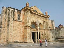
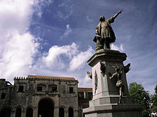
The city's most important colonial buildings include the Catedral Santa María La Menor, called La Catedral Primada de América, America's First Cathedral, which states its distinction; the Alcázar de Colón, America's first castle, once the residence of Viceroy of the Indies Don Diego Colón, a son of Christopher Columbus; the Monasterio de San Francisco, the ruins of the first monastery in America; the Museo de las Casas Reales, the former Palace of the Governor General and the Palace of Royal Audiences; the Parque Colón (Columbus Park), a historic square; the Fortaleza Ozama, the oldest fortress in America; the Pantéon Nacional, a former Jesuit edifice now hosting the remains of various renowned members of the Dominican Order; and the Iglesia del Convento Dominico, the first convent in America.
Throughout its first century, Santo Domingo was the launching pad for much of the exploration and conquest of the New World.[citation needed] The expeditions that led to Hernando Cortes' conquest of Mexico and Balboa's sighting of the Pacific Ocean all started from Santo Domingo.[citation needed]
In 1586, Francis Drake captured the city, which he held for ransom.[5] Drake's invasion and pillaging of Hispaniola so weakened Spanish dominion over the island that for more than 50 years all but the capital was abandoned and left to the mercy of the pirates.[citation needed] An expedition sent by Oliver Cromwell in 1655 attacked the city of Santo Domingo, but was defeated, and withdrew and took Jamaica, instead.[6]
From 1795 to 1822 the city changed hands several times along with the colony it headed. It was ceded to France in 1795, captured by rebellious Haitian slaves in 1801, recovered by France in 1802, recovered by Spain in 1809. In 1821 Santo Domingo became the capital of an independent nation, Haití Español. This was two months later conquered by Haiti. The city and the colony lost much of their Spanish population as a result of these events.[5][7][8]
Santo Domingo was again the capital of a free nation, when Dominicans gained their independence from Haitian rule on February 27, 1844 led by their national hero Juan Pablo Duarte. The city was a prize fought over by various political factions over the succeeding decades of instability. In addition, the country had to fight multiple battles with Haiti; the Battle of March 19, Battle of March 30, Battle of Las Carreras, and Battle of Beler, are a few of the most prominent encounters, mentioned in the national anthem and with city streets named after them.[9] In 1861 Spain returned to the country, having struck a bargain with Dominican leader Pedro Santana whereby the latter was granted several honorific titles and privileges, in exchange for annexing the young nation back to Spanish rule. The Dominican Restoration War began in 1863 however, and in 1865 the country was free again after Spain withdrew.
Over the next two-thirds of a century Santo Domingo and the Dominican Republic went through many revolutions, power changes, and occupation by the United States, 1916–24. The city was struck by hurricane San Zenón in 1930, which caused major damage. After its rebuilding, Santo Domingo was known officially as Ciudad Trujillo in honor of dictator Rafael Leónidas Trujillo, who governed from 1930. Following his assassination in 1961 the city was renamed back to Santo Domingo. It was the scene of street fighting during the 1965 United States occupation of the Dominican Republic.
The year 1992 marked the 500th anniversary, El Quinto Centenario, of Christopher Columbus' Discovery of America. The Columbus Lighthouse – Faro a Colón – with an approximate cost of 400 million Dominican pesos, was erected in Santo Domingo in honor of this occasion.[10]
Geography
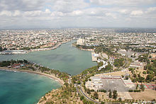 Santo Domingo de Guzmán (DN) and the municipality of Santo Domingo Este (in S.D. Province) are separated by the Ozama River.
The Ozama river flows 148 kilometers before emptying into the Caribbean Sea. Santo Domingo's position on its banks was of great importance to the city's economic development and the growth of trade during colonial times. The Ozama River is where the country's busiest port is located.
Metropolitan Santo Domingo is divided into four municipalities, mostly for administrative reasons. They consist of Santo Domingo de Guzmán National District and three municipal divisions of Santo Domingo Province: Santo Domingo Norte (Villa Mella Municipal District, etc.), Santo Domingo Este (San Isidro Municipal District, etc.), and Santo Domingo Oeste. These three border Santo Domingo de Guzmán on the north, east, and west, respectively. Bajos de Haina, in San Cristóbal Province, borders Santo Domingo Oeste, in the west. The Ozama River and Isabella end at the Center of Santo Domingo.[clarification needed] Santo Domingo is relatively low in altitude, but has several high hills.
Climate
Under the Koppen climate classification, Santo Domingo features a Tropical monsoon climate. The average temperature varies little in the city, because the tropical trade winds help mitigate the heat and humidity throughout the year. Thanks to these trade winds, Santo Domingo seldom experiences the oppressive heat and humidity that one may expect to find in a tropical climate. December and January are the coolest months and July and August are the warmest. Santo Domingo averages 1,445 millimetres (56.9 in) of precipitation per year. Its driest months are from January through April, however, due to the tradewinds, precipitation is seen even during these months. Because its driest month is just below 60 millimetres (2.4 in), Santo Domingo falls under the Tropical monsoon climate category. Like many other nations in the Caribbean, Santo Domingo is very susceptible to hurricanes. The lowest recorded temperature has been 13 °C (55 °F) and the highest 37 °C (99 °F).
Climate data for Santo Domingo, Dominican Republic Month Jan Feb Mar Apr May Jun Jul Aug Sep Oct Nov Dec Year Average high °C (°F) 27
(81)29
(84)29
(84)30
(86)30
(86)31
(88)33
(91)34
(93)31
(88)31
(88)31
(88)29
(84)30.4
(86.8)Daily mean °C (°F) 24
(75)24
(75)25
(77)26
(79)26
(79)27
(81)27
(81)27
(81)27
(81)27
(81)26
(79)25
(77)25.9
(78.7)Average low °C (°F) 16
(61)19
(66)20
(68)21
(70)22
(72)23
(73)24
(75)22
(72)22
(72)22
(72)21
(70)19
(66)20.9
(69.7)Precipitation mm (inches) 64
(2.52)56
(2.2)53
(2.09)71
(2.8)188
(7.4)140
(5.51)145
(5.71)178
(7.01)180
(7.09)188
(7.4)99
(3.9)84
(3.31)1,446
(56.93)Source: Weather Channel[11] Economic development
See also: Downtown Santo Domingo
The city is the center of economic activity in the Dominican Republic. Many national and international firms have their headquarters or regional offices in Santo Domingo. The city attracts many international firms and franchises due to its geographic location, stability, and vibrant economy.The infrastructure is adequate for most business operations; however, power outages continue to be a problem in certain parts of the city. A key element that has helped the city thrive and compete globally is the telecommunications infrastructure. For many years the Dominican Republic has enjoyed a modern and state of the art telecommunications system, due to its privatization and integration with the US system.
Santo Domingo contains a wide variety of incomes, ranging from the extremely poor to the highly rich. Areas of high income families are found in the central Polygon of the city, which is bordered by the Avenida John F. Kennedy ("Avenida" = "Avenue") to the north, Avenida 27 de Febrero to the south, Avenida Winston Churchill to the west and Avenida Máximo Gómez to the east, and is characterized by its mostly residential area and its distinguished nightlife.
Santo Domingo has areas of high development, among them Naco, Arroyo Hondo, Piantini, Paraíso, Las Praderas, Los Prados, Bella Vista, Sarasota and other neighborhoods, which mostly consist of costly buildings and luxury houses, contrasting with the outskirts of the city like Gualey and Capotillo which are less economically developed.
Bella Vista and La Esperilla are currently the neighborhoods with the highest income growth and with tall mega-projects marking the city skyline. Gazcue belongs to the more traditional southeastern area of the city and is characterized by its slightly older constructions, dating from the 1930s to the 1960s.
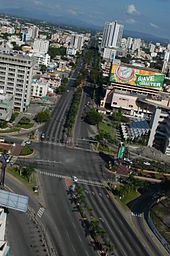
The commercial centers in the city are mostly found on Avenida Winston Churchill, where large plazas, such as Acropolis Center, and large supermarkets are found. This area is home to most of the banks in the city, like Banco Popular Dominicano, Scotiabank, Citibank, Banco BHD, Banco del Progreso, and BanReservas, to name a few. 27 de Febrero Avenue is very commercially successful and is considered the most important crosstown avenue in the city. The oldest mall plazas in the country are Plaza Central and Plaza Naco, which served as the first commercial center in the city, until the recent construction of others, which quickly became new alternatives. Bella Vista Mall and the Acropolis Center are two of the newest malls built in the city, attracting many of the high income families.
Most of the city's poor live outside the center. Some live in extreme conditions of poverty and in slums, intensifying the city's economic contrast.
Government and politics
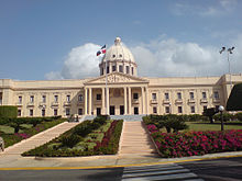
Santo Domingo is the center of the national government of the Dominican Republic. The National Palace, which is the President's office, as well as the National Congress, are located in the metropolitan area. The current mayor of the City of Santo Domingo is Roberto Esmérito Salcedo, of the governing Dominican Liberation Party. The city is administered by the Ayuntamiento del Distrito Nacional (City Hall), which is responsible for municipal functions. The "Policía Nacional" (National Police) and "Policia Turística" (Tourist Police) (POLITUR) are tasked with enforcing city safety.
Landmarks
Famous landmarks in Santo Domingo include the Puerta del Conde, the Puerta de la Misericordia, the Catedral Santa María La Menor (Catedral Primada de América), the National Pantheon and the Alcázar de Colón, all of which are located within the Zona Colonial district of the city. This part was declared a UNESCO World Heritage Site in 1990.
Outside of the colonial quarters, the area surrounding the Malecón (seawall) is a vibrant commercial and tourist center, having as a centerpiece the large obelisk located at the eastern end of George Washington Avenue.
Other places of interest are Plaza de la Cultura, which houses the city's most important cultural venues, such as the Teatro Nacional (National Theater) and the Museum of Modern Arts; the Palacio de Bellas Artes (Palace of Fine Arts), a neoclassical theatre that is the permanent home of the Orquesta Sinfónica Nacional (National Symphony Orchestra); the Parque Mirador Sur, a six square kilometer park in the southwestern part of the city; and the Boulevard 27 de Febrero, a pedestrian promenade located on the busy Avenida 27 de Febrero, which displays many works of art from prominent Dominican artists and sculptors.
Another attraction is the Centro Olímpico Juan Pablo Duarte, a sports complex in the center of Santo Domingo. This complex was used during the 2003 Pan American Games.
Museums
Santo Domingo is the location of numerous museums dedicated to the history of the Dominican Republic. Most of them are within the Zona Colonial District.[10]
- Museum of Alcázar
- Altar de la Patria
- Naval Museum of the Atarazanas
- Museum of the Casas Reales is dedicated to the colonial period
- Museum of Duarte summarizes and shows the history of the movement and struggle for independence
- Museum of Natural History
- Museum of Dominican Man
- World of Ambar Museum
- Museum of Modern Arts
- National Museum of History and Geography is dedicated to all of Dominican history, from pre-Columbian up to contemporary times
Parks and recreational areas
-
- See Also: Santo Domingo Greenbelt
Santo Domingo has various parks, three of which are called Miradores and are located in the north, south, and east sections of the city. Even though these parks are relatively big, Santo Domingo still lacks enough recreational areas. Santo Domingo (D.N) is surrounded by the Santo Domingo Greenbelt.
- Mirador Norte Park, lies in the north of the city, close to Villa Mella
- Enriquillo Park
- Mirador Sur Park, located in the southwest section of the city
- Independencia Park, located in Zona Colonial
- Colón Park, located in Zona Colonial
- Las Praderas Metropolitan Park
- El Malecón, cityfront coastal park
- Dr. Rafael Ma. Moscoso National Botanical Garden (Jardín Botanico Nacional)
- Dominican Republic National Zoo
- Barrio Chino (Chinatown)
- Parque Nuñez de Caceres
Malls and Plazas
- Acropolis Center Mall
- Bella Vista Mall
- Blue Mall
- Diamond Mall
- Malecon Center Mall
- Megacentro
- Plaza Central
- Plaza Las Americas
- Plaza Naco
- Plaza Galerias de Naco
- Novocentro
- Sambil Santo Domingo Mall (under construction)
- Agora Mall (under construction)
- Silver Sun Gallery Mall (under construction)
- Galerias 360 Mall (under construction)
- Megacentro
- Plaza Andalucia
- Plaza Paseo de la Churchill
- Plaza Cataluña
Transportation
Informal
Santo Domingo is provided with a variety of informal transportation systems. These include motoconchos (motorcycle taxis), guaguas/voladoras (public buses that are known for their generally bad conditions and the drivers' reckless driving), and carros publicos/conchos (shared taxis that stop at certain intervals or wherever there are passengers on a street). There are however several bus services, such as the government owned and operated OMSA, which has a fleet of air conditioned buses with regular stops. OMSA operates long routes that traverse the metro area and are very popular with poor and middle class people. Efforts are being made to modernize the fleet and to complement the new subway system. However, due to the long hours of operation, long routes and high demand, coupled with high parts costs, these buses' lifespans are usually less than ten years.
Highways
Main article: Highways and routes in the Dominican RepublicSanto Domingo is the terminus for four of the five national highways. The city is connected with the southwest of the republic by the national highway DR-2 (Avenida George Washington and Autopista 30 de Mayo), and with the cities of the country's northwest by DR-1 (Expreso Kennedy, Corredor Duarte), which serves as a direct link to the city of Santiago de los Caballeros. DR-3 (Expreso 27 de Febrero/Autopista de Las Américas) connects Santo Domingo directly to the east of the country, including the cities of San Pedro de Macoris, La Romana, and major tourist sites like Punta Cana and Bavaro, and to the Samaná Province (in the northeast) via the Samana Highway.
Rail
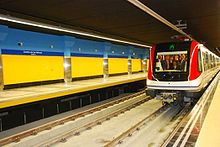
Main article: Santo Domingo MetroThe Santo Domingo Metro is a 15 km underground and elevated system consisting of six proposed lines. The first line begins elevated at Villa Mella (in Santo Domingo Norte)—located north of the Isabela River and north of the city center—and ends at Centro de los Héroes on the southern coast of Santo Domingo, near the seawall district (Malecón). Some of the stops on the first line are the Teatro Nacional, the main campus of the Universidad Autónoma de Santo Domingo (UASD; Autonomous University of Santo Domingo) and Avenida Lincoln. The first line is already in service.
The second line, currently under construction, is said to run in an east-west direction beneath Expreso Kennedy, crossing the first line at Maximo Gómez Avenue. The third line will also run in an east-west direction, beneath Expreso 27 de Febrero.[citation needed]
Airports
- Las Américas International Airport
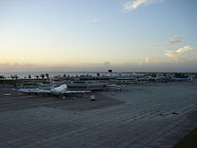
Santo Domingo is served by two international airports, the main one being Las Américas International Airport (Spanish: Aeropuerto Internacional de las Americas Dr. José Francisco Peña Gómez). The airport has two terminals; the newer one, just completed in 2006, added five more gates on the northern end of the facility. As of 2010, the airport handled over 3.4 million passengers per year.[12] Las Américas is located in Punta Caucedo, 15 kilometers east of the National District on DR-3. It is serviced by such airlines as Sunrise Airways.
- La Isabela International Airport
The Aeropuerto Internacional La Isabela is a secondary, newly constructed airport located in the northern section of the city, within kilometres of the city center. It is not currently used as a major international airport, servicing mostly domestic and charter flights. It was built to replace the obsolete Herrera Airport, which was considered by many too dangerous due to the proximity to commercial and residential areas. Many pilots also cited the length of the runway as inadequate for most private jets. La Isabela Airport is also conveniently located just on the outskirts of the city and most of the internal flights of the country can be carried out here; flights to the north of the island (for example, to Samaná) can be booked here with such airlines as Air Century, Sunrise Airways, Caribair and Aerodomca.
Ports
- Port of Santo Domingo: Sans Souci
The Port of Santo Domingo is located on the Ozama River. Its location at the center of the Caribbean is well suited for flexible itinerary planning and has excellent support, road and airport infrastructure within the Santo Domingo region, which facilitate access and transfers. The port is suitable for both turnaround and transit calls.
The port's renovation is part of a major redevelopment project, aimed at integrating the port area and the Zona Colonial and foster a cruise, yacht, and high-end tourism destination. Supported by legislation approved in 2005, the project, developed by the Sans Souci Group, also includes the development of a new sports marina and a 122-acre (0.49 km2) mixed-leisure real estate development adjacent to the port.
Communication
Television
There are 15 television stations (both UHF and VHF) in Santo Domingo. Santo Domingo has the greatest number of television signals in the country, followed by Santiago.
Additional cable television channels are provided by companies like Aster, Cable TV Dominicana, SKY Dominicana, and Telecable.
VHF (channel number in parentheses):
- Tele Antillas (2)
- CERTV (4)
- Telemicro (5)
- Antena Latina (7)
- Color Visión (9)
- Telesistema (11)
- Telecentro (13)
UHF:
- Digital 15 (15)
- Telefuturo (23)
- RNN (27)
- Supercanal (33)
- CDN (37)
- Coral 39 (39)
- Teleradio América (canal 45)
- Santo Domingo TV (canal 69)
Radio
In Santo Domingo there are 100 different stations in AM frequency and 44 in FM frequency.
Telephone services
CODETEL (Compañía Dominicana de Teléfonos) was originally the provider of telephone service in the Dominican Republic since the 1940s. The company was later bought by GTE (later Verizon). By 2004 the company was named Verizon Dominicana and was later sold to América Móvil; it was named CODETEL again, as a marketing strategy. The company uses the name Claro GSM/CDMA for its cellular phone division. The second landline competitor is Tricom, which is a minor competitor, Codetel being the dominant service provider in the country. Other mobile providers include Tricom CDMA, Viva CDMA/GSM, and Orange GSM, the last and Claro having the majority of the mobile phone service provider market.
The national area codes are 809 and 829. In 2005 the 829 area code was made an overlay of 809, due to the increase of fax, internet, mobile, and ground lines in the last decade. The Dominican Republic uses +1-809-XXX-XXXX, +1-829-XXX-XXXX, and +1-849-XXX-XXXX as the official format for telephone numbers.
In late May 2009, INDOTEL raised and adapted the idea of introducing a new area code (849), with the purpose of increasing the availability of more line numbers in the country. INDOTEL said they will launch a new television campaign to promote the new code.
Internet
.do is the internet code for The Dominican Republic. The Dominican Republic has an estimated 2,000,000 internet users.
Education
There are eighteen universities in Santo Domingo, the highest number of any city in the Dominican Republic. Established in 1538, the Universidad Autónoma de Santo Domingo (UASD) is the oldest university in the Americas and is also the only public university in the city. Santo Domingo holds the nation's highest percentage of residents with a higher education degree.[citation needed]
- Universidad Autónoma de Santo Domingo (UASD)
- Universidad Adventista Dominicana (UNAD)
- Universidad APEC (UNAPEC)
- Instituto Tecnológico de Santo Domingo (INTEC)
- Universidad del Caribe (UNICARIBE)
- Universidad Iberoamericana (UNIBE) (UNIBE)
- Universidad Católica Santo Domingo (UCSD)
- Universidad de la Tercera Edad (UTE)
- Universidad Tecnológica de Santiago (UTESA)
- Universidad Nacional Pedro Henríquez Ureña (UNPHU)
- Instituto de Ciencias Exactas (INCE)
- Universidad Organización y Método (O&M)
- Universidad Interamericana (UNICA)
- Universidad Eugenio María de Hostos (UNIREMOS)
- Universidad Francisco Henríquez y Carvajal (UFHEC)
- Universidad Instituto Cultural Domínico Americano (UNICDA)
- Pontificia Universidad Católica Madre y Maestra (PUCMM)
- Instituto Tecnológico de las Americas (ITLA)
- Universidad de Psicologia Industrial Dominicana (UPID)
Photo gallery
Sister cities
Santo Domingo has three sister cities designated by Sister Cities International:[13]
 Miami-Dade County, Florida, United States[13]
 New York City, New York, United States[13]
 Providence, Rhode Island, United States[13]
Santo Domingo also has twinning agreements with the following sister cities:
Notable residents
- Moisés Alou – former Major League Baseball outfielder
- José Bautista - Major League Baseball outfielder/infielder
- Adrián Beltré – Major League Baseball infielder
- Milagros Cabral – volleyball player in the Korea League
- Melky Cabrera – Major League Baseball outfielder
- Francisco Cordero – Major League Baseball pitcher
- Enrique Cruz – former Major League Baseball infielder
- Francisco García – National Basketball Association (NBA) player
- Juan Luis Guerra – singer, composer
- Julio Iglesias – Spanish singer, composer, developer of PUNTACANA Resort and Club
- D'Angelo Jimenez – Major League Baseball infielder
- Rafael Landestoy – Major League Baseball infielder
- Michael Martínez - Major League Baseball infielder
- Pedro Martínez – Major League Baseball pitcher
- Michel Camilo – jazz pianist, composer
- David Ortiz – Major League Baseball player
- Olivia Peguero - Landscape and botanical artist
- Carlos Peña – Major League Baseball infielder
- Roberto Peña – former Major League Baseball infielder
- Santiago Perez – Major League Baseball player
- Albert Pujols – Major League Baseball infielder
- Aramis Ramirez – Major League Baseball infielder
- Manny Ramírez – Major League Baseball outfielder
- Oscar de la Renta – fashion designer, developer of PUNTACANA Resort and Club
- Ángel Salomé – Major League Baseball catcher
- Sammy Sosa – former Major League Baseball outfielder
- William Suero – Major League Baseball infielder
- Jose Veras – Major League Baseball pitcher
- Edinson Volquez – Major League Baseball pitcher
- Wilfrido Vargas – merengue singer
- Félix Sánchez - 400m hurdles Olympic champion
- Aumi Guerra - Bowling World Cup Champion (2010)
See also
- List of cities in the Caribbean
References
- ^ Superficies a nivel de municipios, Oficina Nacional de Estadística
- ^ De la Fuente, Santiago (1976) (in Spanish). Geografía Dominicana. Santo Domingo, Dominican Republic: Editora Colegial Quisqueyana.
- ^ http://censo2010.one.gob.do/index.php
- ^ Meining 1986:9
- ^ a b "Dominican Republic - THE FIRST COLONY". Library of Congress. http://countrystudies.us/dominican-republic/3.htm. Retrieved 2009-03-18.
- ^ Marley, David (1998). Wars of the Americas. ABC-CLIO. pp. 148–149. ISBN 0874368375, 9780874368376. http://books.google.com/books?id=rdvp3cGJUZoC&pg=PA148&dq=%22Santo+Domingo%22+1655+Penn+Venables&output=html.
- ^ "Elections and Events 1791-1849". University of California-San Diego. http://libraries.ucsd.edu/locations/sshl/resources/featured-collections/latin-american-elections-statistics/dominican-republic/elections-and-events-17911849.html. Retrieved 2009-03-18.
- ^ Mary Louise Pratt, Imperial Eyes, 2007, p. 70
- ^ "City street map of Santo Domingo at www.colonialzone-dr.com". http://www.colonialzone-dr.com/stodgo_map-lenin.pdf. Retrieved 2009-03-20.
- ^ a b "Secretaría de Estado de Cultura". http://www.cultura.gov.do/dependencias/museos/direcciongeneraldemuseos.htm. Retrieved 2009-03-18.
- ^ "Weather Channel: Historical Weather for Santo Domingo, Dominican Republic". http://www.weather.com/outlook/travel/businesstraveler/wxclimatology/monthly/graph/DRXX0009?from=36hr_bottomnav_business.
- ^ Aerodom Siglo XXI. "Number of Passengers by Airport in 2004 (in Spanish)". Archived from the original on 2006-10-05. http://web.archive.org/web/20061005075439/http://www.aerodom.com/2005/aeropuertos.htm. Retrieved 2006-12-17.
- ^ a b c d Online Directory: Dominican Republic, Caribbean Sister Cities International, Inc. (SCI)
- ^ a b c d "Memoria Anual, Agosto 2002-Agosto 2003". Ayuntamiento del Distrito Nacional. pp. 66–67. http://www.adn.gov.do/documents/memoria_adn_2002-2003.pdf. Retrieved 2008-07-23.
- ^ "Mapa Mundi de las ciudades hermanadas". Ayuntamiento de Madrid. http://www.munimadrid.es/portal/site/munimadrid/menuitem.dbd5147a4ba1b0aa7d245f019fc08a0c/?vgnextoid=4e84399a03003110VgnVCM2000000c205a0aRCRD&vgnextchannel=4e98823d3a37a010VgnVCM100000d90ca8c0RCRD&vgnextfmt=especial1&idContenido=684a7aefd9b5b010VgnVCM100000d90ca8c0RCRD. Retrieved 2008-07-23.
- ^ [1]
- ^ La Guardia y Santo Domingo, dos ciudades hermanas (Spanish)
- Meinig, D.W. (1986). The Shaping of America: a Geographic Perspective on 500 Years of History. Volume I - Atlantic America, 1492-1800. New Haven: Yale University Press. ISBN 0-300-03882-8
- Santo Domingo; Fragmentos De Patria by Banreservas ISBN 99934-898-9-5
External links
- Dominican Explorer/Dominican Republic Travel Guide
- Dominican Republic Weather Information
- Fly Dominican Republic/Dominican Republic Pilots Guide
- Guide to Santo Domingo's Zona Colonial
 Media related to Santo Domingo at Wikimedia Commons24 de Abril • 30 de Mayo • Altos de Arroyo Hondo • Arroyo Manzano • Atala • Bella Vista • Buenos Aires (Independencia) • Cacique • Centro de Los Heroes • Centro Olímpico Duarte
Cerros de Arroyo Hondo • Ciudad Colonial • Ciudad Nueva • Ciudad Universitaria • Cristo Rey • Domingo Sabio • El Millón • Ensanche Capotillo • Ensanche Espaillat • Ensanche La Fé
Ensanche Luperón • Ensanche Naco • Ensanche Simón Bolívar • Gazcue • General Antonio Duvergé • Gualey • Honduras del Norte • Honduras del Oeste • Jardín Botanico • Jardín Zoologico
Jardínes del Sur • Julieta Morales • La Agustina • La Esperilla • La Hondonada • La Isabela • La Julia • La Zurza • Los Cacicazgos • Los Jardínes
Los Peralejos • Los Prados • Los Restauradores • Los Ríos • María Auxiliadora • Mejoramiento Social • Mirador Norte • Mirador Sur • Miraflores • Miramar
Nuestra Señora de la Paz • Nuevo Arroyo Hondo • Palma Real • Paraíso • Paseo de los Indíos • Piantini • Puerto Isabela • Punta Caucedo • Quisqueya • Renacimiento
San Carlos • San Diego • San Geronímo • San Juan Bosco • Tropical Metaldom • Viejo Arroyo Hondo • Villa Consuelo • Villa Francisca • Villa JuanaSee also: Dominican Republic • Provinces • Municipalities Provincial capitals of the Dominican Republic Azua · Baní · Barahona · Bonao · Comendador · Cotuí · Dajabón · El Seibo · Hato Mayor · Higüey · Jimaní · La Romana · La Vega · Mao · Moca · Monte Cristi · Monte Plata · Nagua · Neiba · Pedernales · Puerto Plata · Sabaneta · Salcedo · Samaná · San Cristóbal · San Francisco de Macorís · San José de Ocoa · San Juan de la Maguana · San Pedro de Macorís · Santiago de los Caballeros · Santo Domingo · Santo Domingo Este

Pan American Games host cities 1951: Buenos Aires • 1955: Mexico City • 1959: Chicago • 1963: São Paulo • 1967: Winnipeg • 1971: Santiago de Cali • 1975: Mexico City • 1979: San Juan • 1983: Caracas • 1987: Indianapolis • 1991: Havana • 1995: Mar del Plata • 1999: Winnipeg • 2003: Santo Domingo • 2007: Rio de Janeiro • 2011: Guadalajara • 2015: Toronto
Categories:- Santo Domingo
- Capitals in North America
- History of Hispaniola
- Populated places in the Dominican Republic
- Populated places established in the 1490s
- Port cities in the Caribbean
- Spanish West Indies
- 1496 establishments
Wikimedia Foundation. 2010.

