- San Salvador
Infobox Settlement
official_name = San Salvador
other_name = "El Valle de las Hamacas"
native_name =
nickname = San Sivar
settlement_type =
motto =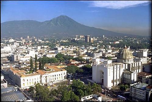
imagesize = 300px
image_caption = San Salvador downtown
flag_size = 100px
image_
seal_size = 75px
image_shield =
shield_size =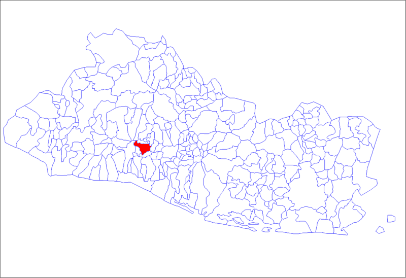
mapsize = 180px
map_caption =
mapsize1 = 180px
map_caption1 =
image_dot_
dot_mapsize =
dot_map_caption =
dot_x = |dot_y =
pushpin_
pushpin_label_position =
pushpin_map_caption =
pushpin_mapsize =
subdivision_type =Country
subdivision_name = SLV
subdivision_type1 =
subdivision_name1 =
subdivision_type2 = Department
subdivision_name2 = San Salvador
government_footnotes =
government_type =
leader_title =Mayor
leader_name =Violeta Menjívar
leader_title1 =
leader_name1 =
leader_title2 =
leader_name2 =
leader_title3 =
leader_name3 =
leader_title4 =
leader_name4 =
established_title = Established
established_date = 1525
established_title2 =
established_date2 =
established_title3 =
established_date3 =
area_magnitude = 1 E8
unit_pref =
area_footnotes =
area_total_km2 = 72.27
area_land_km2 =
area_water_km2 =
area_total_sq_mi =
area_land_sq_mi =
area_water_sq_mi =
area_water_percent =
area_urban_km2 =
area_urban_sq_mi =
area_metro_km2 = 220
area_metro_sq_mi =
area_blank1_title =
area_blank1_km2 =
area_blank1_sq_mi =
population_as_of =2007
population_footnotes =
population_note =
population_total =
population_density_km2 =
population_density_sq_mi =
population_metro = 1,566,629
population_density_metro_km2 =
population_density_metro_sq_mi =
population_urban =
population_density_urban_km2 =
population_density_urban_sq_mi =
population_blank1_title =
population_blank1 =
population_density_blank1_km2 =
population_density_blank1_sq_mi =
timezone =
utc_offset =
timezone_DST =
utc_offset_DST =
latd=13|latm=41 |lats=24.00 |latNS=N
longd=89|longm= 11|longs= 24.01|longEW=W
elevation_footnotes =
elevation =
elevation_ft =
postal_code_type =
postal_code =
area_code =
blank_name =
blank_info =
blank1_name =
blank1_info =
website = http://www.amss.gob.sv/
footnotes =San Salvador is the
capital and largest city of the nation ofEl Salvador . The second most populous city inCentral America , afterGuatemala City , and the metro covers an area of 568 km² (220 sq mi) and is home to nearly 1.6 million people. ["Resultados Oficiales de los Censos Nacionales VI de Población y V de Vivienda 2007", [http://sig.censos.gob.sv/outdescargas/Resultados%20VI%20Censo%20de%20Población%20V%20de%20Vivienda%202007.pdf] ] Home to one-half of El Salvador's wealth, the city's per capita GDP - PPP is approximately USD11,200, compared to a national average of USD5,260 (2002). [Informe sobre Desarrollo Humano El Salvador 2003, [http://hdr.undp.org/docs/reports/national/ELS_El_Salvador/El_Salvador_2003_sp.pdf] ]History
The origins of the city can be traced to before the Spanish Conquest. It is near the present location of San Salvador that the
Pipil groups, established their capital,Cuscatlán . Not very much is known about this city, since it was abandoned by its inhabitants in an effort to avoid Spanish rule.Under the orders of
Pedro de Alvarado ,Gonzalo de Alvarado andDiego de Holgiun were ordered to take the settlement they found and to develop it. Diego de Holgiun became the first mayor of San Salvador as the town was founded on April 1, 1525. However, in the sixteenth century, it was rebuilt and changed locations twice afterwards 1528 and 1545. Originally founded in what is now the archaeological site Ciudad Vieja, north of the present-day city, it was moved to the Valle de Las Hamacas or the Acelhuate Valley, named so due to the intense seismic activity that characterizes it, which boasted more space and more fertile land, thanks to the pristine and now extremelypolluted Acelhuate River. As the population of the country remained relatively small up until the early twentieth century, the city grew slowly.Geography
The city's altitude averages convert|560|m|ft|spell=us above sea level located, on a valley on the skirts of the
Quezaltepec volcano or San Salvador. In fact, the valley got its nickname from the Spaniards who called the area"El Valle de las Hamacas" ("The Valley of the Hammocks") due to its constant seismic activity. [ [http://www.alfatravelguide.com/english/sv/san-salvador.asp San Salvador, the Capital of El Salvador - AlfaTravelGuide.com ] ]Climate
San Salvador is mainly hot, the coldest months being November, December, January, and February. The temperature is very different at midday than midnight, the factors being the humidity levels, which vary as the day passes. The highest reading ever recorded in San Salvador is convert|38.5|°C|°F, the lowest being convert|8.2|°C|°F. The highest dew point is convert|27|°C|°F and the lowest convert|-10|°C|°F. San Salvador has two seasons: rainy and dry. October, November, December, January, February and March being the dry seasons, and April, May, June, July, August and September the rainy.
Demographics
Approximately 89% of the population is
mestizo (mix of Indigenous and European ancestry), 9% isEurope an, and the rest is Indigenous and other small ethnic groups, including Chinese,Jewish andArabs .Transportation
Airport
San Salvador was first served by
Ilopango International Airport , but in January 31, 1980, Ilopango was substituted by the biggerComalapa International Airport which took all the International flights.Roads
The city offers the widest boulevards in Central America and is served by a railroad that connects to other cities such as
Soyapango andApopa .ocial issues
Crime
The security situation has taken a downturn in San Salvador within the last five years. In 2002 there were 162 intentional homicides in the city of San Salvador. This increased sharply over the next three years to 465, with a slight decrease during 2006 to 456. [cite web|url=http:/fuck it/www.elfaro.net/secciones/Noticias/20061211/homicidios2006.swf |title=La evolución de los homicidios |accessdate=2008-06-20 |publisher=ELFARO |language=Spanish] [cite web|url=http://www.ocavi.com/docs_files/file_401.pdf |title=Homicidios en siete municipios altamente poblados en El Salvador |accessdate=2008-06-20 |format=PDF |publisher=OCAVI |language=Spanish]
Pollution
Pollution remains one of the city's biggest problems. Located in a valley, San Salvador is a perfect pollution trap. Fueling this, the city struggles with an increasing traffic problem. New highways and arterial roads offer some relief. According to a study by theUnited Nations , El Salvador was the second worst polluter ofcarbon dioxide emissions in Central America.Disasters
The city has suffered from severe
earthquake s over the years, the most disastrous of which occurred in 1854. Also worthy of mentioning is the 1917 eruption of the San Salvador volcano, which resulted in three major earthquakes and damaged the city so extensively that the government was forced to move the capital to the present-day city of Santa Tecla, then named Nueva San Salvador. The most recent earthquake, in 2001, resulted in considerable damage, especially in Las Colinas suburb where a landslide destroyed homes and killed many people. During the 1980s, conflicts in El Salvador erupted into a civil war, and many people fled to the city since most of the fighting occurred outside of it (San Salvador itself was not directly affected by the war until the final offensive of 1989).Landmarks
*Catedral Metropolitana, Metropolitan Cathedral
*Teatro Nacional de El Salvador , the National Theatre of El Salvador
*Palacio Nacional, the National Palace
*Monumento alSalvador del Mundo , Monument to the Savior of the World
*Casa Presidencial, the Presidential Mansion
*Monumento a La Libertad, Monument to Liberty
*Torre Cuscatlan , a city landmark owned byBanco Cuscatlán .Gallery of San Salvador
ister Cities
*
*
*
*
*Taipei ,Taiwan
*Los Angeles ,United States References
External links
* [http://www.amss.gob.sv/ Municipality of the city of San Salvador]
*wikitravel
* [http://www.4elsalvador.com/el%20salvador%20san%20salvador.htm San Salvador city tour. El Salvador en Imágenes]
* [http://www.medicosdeelsalvador.com Medical and health information in San Salvador]

Wikimedia Foundation. 2010.