- Kingston, Jamaica
-
Kingston Downtown Kingston and the Port of Kingston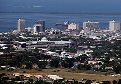
Motto: A city which hath foundations[1] Location of Kingston shown within Jamaica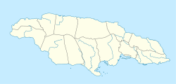
 Kingston
Coordinates: 17°59′N 76°48′W / 17.983°N 76.8°WCoordinates: 17°59′N 76°48′W / 17.983°N 76.8°W Country  Jamaica
County Surrey Parish Kingston and St. Andrew Established 1692 Government - Mayor Desmond McKenzie Area - Total 480 km2 (185.3 sq mi) Elevation 9 m (30 ft) Population (2001) - Total 651,880 - Density 1,358/km2 (3,517.2/sq mi) - Kingston Parish 96,052 - St. Andrew Parish 555,828 Time zone EST (UTC-5) Kingston is the capital and largest city of Jamaica, located on the southeastern coast of the island. It faces a natural harbour protected by the Palisadoes, a long sand spit which connects the town of Port Royal and the Norman Manley International Airport to the rest of the island. In the Americas, Kingston is the largest predominantly English-speaking city south of the United States.
The local government bodies of the parishes of Kingston and St. Andrew were amalgamated by the Kingston and St. Andrew Corporation Act of 1923, to form the Kingston and St. Andrew Corporation (KSAC). Greater Kingston, or the "Corporate Area" refers to those areas under the KSAC; however, it does not solely refer to Kingston Parish, which only consists of the old downtown and Port Royal. Kingston Parish had a population of 96,052, and St. Andrew parish had a population of 555,828 in 2001.[2] Kingston is only bordered by Saint Andrew to the east, west and north. The geographical border for the parish of Kingston ends at East Street, West Street and North Street.
The city proper is bounded by Six Miles to the west, Stony Hill to the north, Papine to the northeast and Harbour View to the east, communities in urban and suburban Saint Andrew. Communities in rural St. Andrew such as Gordon Town, Mavis Bank, Lawrence Tavern, Mt. Airy and Bull Bay would not be described as being in Kingston city.
Two parts make up the central area of Kingston: the historic but troubled Downtown, and New Kingston is served by Norman Manley International Airport and also by the smaller and primarily domestic Tinson Pen Aerodrome.
Contents
History
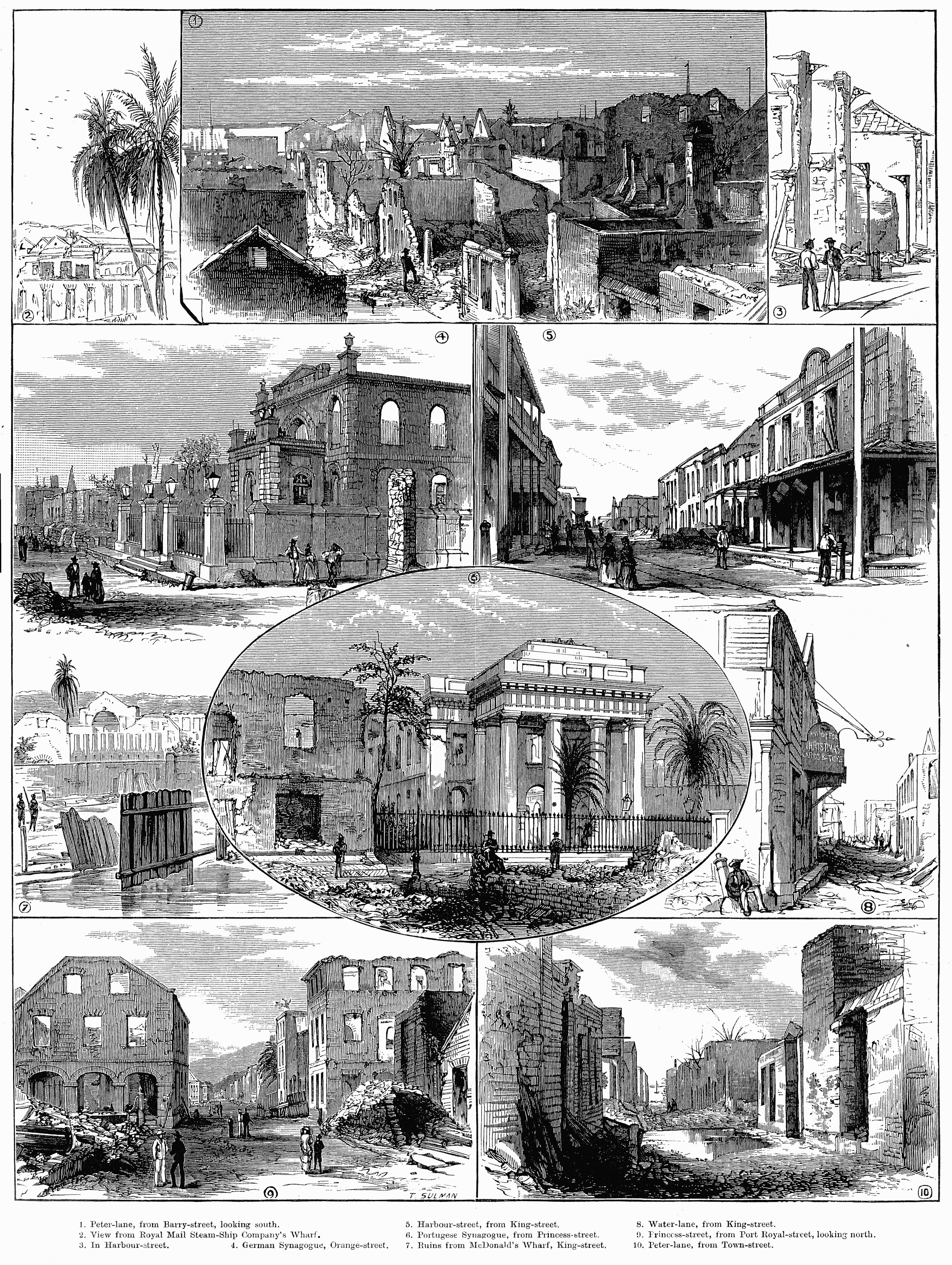
 Scenes in Kingston after the 1882 fire.
 Map of Kingston 1897
Kingston was founded in July 1692[citation needed] as a place for refugees and survivors of the 1692 earthquake that destroyed Port Royal. Before the earthquake, Kingston’s functions were purely agricultural. The earthquake survivors set up a refugee camp on the sea front. Approximately two thousand people died due to mosquito-borne diseases. Initially the refugees lived in a tented camp on Colonel Barry's Hog Crawle. The town did not begin to grow until after the further destruction of Port Royal by the Nick Catania Pirate Fleet's fire in 1703. Surveyor John Goffe drew up a plan for the town based on a grid bounded by North, East, West and Harbour Streets. By 1716 it had become the largest town and the centre of trade for Jamaica. The government sold land to people with the regulation that they purchase no more than the amount of the land that they owned in Port Royal, and only land on the sea front. Gradually wealthy merchants began to move their residences from above their businesses to the farm lands north on the plains of Liguanea.
The first free school, Wolmer's, was founded in 1729[3] and there was a theatre, first on Harbour Street and then moved in 1774 to North Parade. Both are still in existence. In 1755 the governor, Sir Charles Knowles, had decided to transfer the government offices from Spanish Town to Kingston. It was thought by some to be an unsuitable location for the Assembly in close proximity to the moral distractions of Kingston, and the next governor rescinded the Act. However, by 1780 the population of Kingston was 11,000, and the merchants began lobbying for the administrative capital to be transferred from Spanish Town, which was by then eclipsed by the commercial activity in Kingston.
By the end of the 18th century, the city contained more than 3,000 brick buildings. The harbour fostered trade, and played part in several naval wars of the 18th century. Kingston took over the functions of Spanish Town (the capital at the time). These functions included agriculture, commercial, processing, and a main transportation hub to and from Kingston and other sections of the island.
The government passed an act to transfer the government offices to Kingston from Spanish Town, which occurred in 1872. It kept this status when the island was granted independence in 1962.
 Bird's eye view of Kingston after the 1907 earthquake
In 1907, 800 people died in another earthquake known as the 1907 Kingston earthquake, destroying nearly all the historical buildings south of Parade in the city. That was when a restriction of no more than 60 feet (18 m) was instituted on buildings in the central business district. These three story high buildings were built with reinforced concrete. Construction on King Street in the city was the first area to breach this building code.
During the 1930s, island-wide riots led to the development of trade unions and political parties to represent workers.
The city became home to the Mona campus of the University of the West Indies founded in 1948 with 24 medical students.
 View of the Uptown New Kingston skyline (2007)
Not until the 1960s did major change occur in the development of Kingston’s central business district. The international attention of reggae music at that time coincided with the expansion and development of 95 acres (38 ha) of the Downtown Kingston waterfront area. These developments led to an influx of shops and offices, and the development of a new financial center: New Kingston, which replaced the Knutsford Racetrack. Multi-story buildings and boulevards were placed within that section.
In 1966 Kingston was the host city to the Commonwealth Games.
The western section of the city was not the focus of development, and that area proved to be politically tense. The 1970s saw deteriorating economic conditions that led to recurrent violence and a decline in tourism which later affected the island.
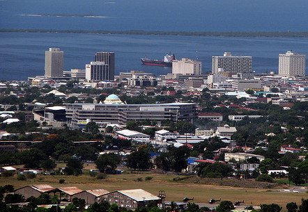
 View of the Downtown Kingston waterfront showing the Bank of Nova Scotia and the Bank of Jamaica
In the 1980 general elections, the democratic socialist People's National Party (PNP) government was voted out, and subsequent governments have been more market-oriented. Within a global urban era, the 1990s saw that Kingston has made efforts to modernize and develop its city structure and functions. Various organizations such as The Kingston Restoration Company, the Urban Development Corporation (UDC), the Port Authority of Jamaica, and the Port Royal Development Company, among others sought to develop the urban structure of the city.
Demographics
The majority of the population of Kingston is of African descent. Large minority ethnic groups include East Indians and Chinese, who came to the country as indentured servants in the late 19th century. The Chinese occupy important roles in Jamaica's economy especially in the retail markets in Downtown Kingston and the wider metropolitan area. Europeans, mostly descending from immigrants from Germany and Great Britain as well as Christian Syrians and Lebanese form one of the most influential ethnic groups in not only Kingston, but the entire island. Though a minority ethnic group, the Lebanese were able to give Jamaica one of its prime ministers in the form of Edward Philip George Seaga. Multi-racial Jamaicans continue to form the second largest racial group and there is also a small Jewish population in the city.[4]
Religion
There is a wide variety of Christian churches in the city. Most are Protestant, a legacy of British colonization of the island. The chief denominations are Church of God[disambiguation needed
 ], Baptist, Anglican, Methodist, Roman Catholic, Seventh-day Adventist, and Pentecostal. Afro-Christian syncretic religions such as the Rastafari movement also have a significant following.
The Shaare Shalom Synagogue serves Kingston's Jewish population. The city also has communities of Buddhists and Muslims. The Islamic Council of Jamaica and the Islamic Education and Dawah Center are both located in Kingston. There are 3 units of The Church of Jesus Christ of Latter-day Saints in the city.[5]
Economy
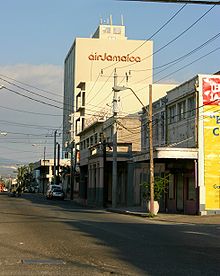 Air Jamaica headquarters
Kingston plays a central role in Jamaica's economy. The vast majority of economic activity takes place within Kingston, and as most government ministries are located in the city, it is a key force in legislation in regards to Jamaica's finances. The high population density of the capital city means that the majority of monetary transactions occur in Kingston - stimulating much of Jamaica's local economy. Many multinational conglomerates and financial institutions are headquartered in and around the Kingston Metropolitan Area.[citation needed] The Jamaican government has expressed a desire and as such, passed legislation to transform Kingston into an International Financial Centre. This IFC will most likely be located along the Kingston waterfront, and be apart of the wider revitalization and gentrification programme for Downtown Kingston.
Air Jamaica is headquartered in Kingston.[6]
Geography
Climate
Kingston is surrounded by the Blue Mountains, Red Hills, Long Mountain and the Kingston Harbour. The city is situated on the Liguanea Plain, an alluvial plain alongside the Hope River. Kingston experiences frequent earthquakes, including the 1907 earthquake.
Kingston has a tropical climate, specifically a tropical wet-and-dry climate, characterized by a wet season from May to November, which coincides with the hurricane season, and a dry season from December to April. During the dry season, there is not much rainfall, however, cold and stationary fronts occur at this time, and often bring heavy showers, especially in March. Kingston is located in the rain shadow of the Blue Mountains; therefore, little to none of the moisture carried by the Northeast Trade Winds falls over Kingston, causing Kingston to be very dry in comparison to Portland and Saint Mary on the windward side of the Blue Mountains. Kingston is on a coastal location, hence it comes under the influence of the sea, though dense urban development can negate this effect. In the 21st century, Kingston has experienced temperatures as high as 36°C (97°F) and temperatures as low as 14°C (57,4°F). Between 1895 and 1990, the total average rainfall was recorded at 909.7 mm (35.8 inches), the highest monthly average rainfall recorded in October at 181.1 mm (7.1 inches), and the lowest monthly average rainfall recorded in March at 22.7 mm (0.9 inches).[7]
Climate data for Kingston Month Jan Feb Mar Apr May Jun Jul Aug Sep Oct Nov Dec Year Record high °C (°F) 34
(93)33
(91)34
(93)34
(93)34
(93)35
(95)36
(97)36
(97)36
(97)36
(97)36
(97)36
(97)36
(97)Average high °C (°F) 30
(86)30
(86)30
(86)31
(88)31
(88)32
(90)32
(90)32
(90)32
(90)31
(88)31
(88)31
(88)31 Average low °C (°F) 19
(66)19
(66)20
(68)21
(70)22
(72)23
(73)23
(73)23
(73)23
(73)23
(73)22
(72)21
(70)22 Record low °C (°F) 14
(57)15
(59)14
(57)17
(63)19
(66)20
(68)19
(66)20
(68)20
(68)18
(64)17
(63)14
(57)14
(57)Precipitation mm (inches) 23
(0.91)15
(0.59)23
(0.91)31
(1.22)102
(4.02)89
(3.5)89
(3.5)91
(3.58)99
(3.9)180
(7.09)74
(2.91)36
(1.42)852
(33.54)Source: BBC Weather [8] Transportation
Road
The St William Grant Park (Parade) in the heart of downtown Kingston is the starting point for three of Jamaica's four A roads, namely the A1 (Kingston to Lucea), the A3 (Kingston to Saint Ann's Bay) and the A4 (Kingston to Annotto Bay), while the city itself is provided with a dense network of trunk, main, secondary and minor roads. It also consists of the Highway 2000, Jamaica which runs through Portmore, Ocho Rios, and Mandeville
Kingston is served well by a modern bus system (JUTC), mini buses, and taxis, which operate throughout the city with major hubs at Parade, Cross Roads, Half Way Tree and elsewhere.[9]
Private car ownership levels are high,[citation needed] and like many major urban conurbations Kingston suffers from frequent traffic jams and pollution.[citation needed]
Rail
The now disused Kingston railway station served the Kingston to Montego Bay main line with branches from Spanish Town to Ewarton, Bog Walk to Port Antonio, Linstead to New Works and May pen to Frankfield.
The station opened in 1845 and closed in October 1992 when all passenger traffic on Jamaica's railways abruptly ceased.[10]
Air
Kingston's international airport is Norman Manley International Airport while Tinson Pen Aerodrome provides domestic services.
Sea
Historically, the Kingston waterfront was Jamaica's main port with many finger piers at which freighters and passenger liners could dock. More recently, with the containerisation of freight, the port has moved to Newport West.
Law Enforcement
The Jamaica Constabulary Force, Jamaica's police force, is based on Old Hope Road near Liguanea. Smaller police stations, such as Hunt's Bay, Matilda's Corner and Half-Way-Tree, are dispersed across the Corporate Area. The Supreme Court of Jamaica is also located in Kingston. Other courts, such as the Half-Way-Tree Resident Magistrate's Court, Gun Court, Traffic Court and Family Court, make Kingston their home. The Jamaica Defence Force (JDF) has its headquarters at Up Park Camp near New Kingston and Cross Roads. The JDF also operates a major naval base at Port Royal.
Media and telecommunications
The Gleaner Company, the Jamaica Observer and the Sunday Herald, three of Jamaica's large newspaper companies, make their home in Kingston. Several television and radio stations including Television Jamaica (TVJ), CVM TV, RJR 94 FM,TBC 88.5 FM, Hitz 92 FM, FAME 95 FM, LOVE TV, ZIP 103, Kool 97 FM and LOVE FM, are all based in Kingston. Kingston generally has an adequate telecommunications service, administered by either Cable and Wireless or Flow Jamaica. Cellular phone service is also very strong in Kingston, especially since Cable & Wireless, Digicel and Claro, Jamaica’s three cellular providers, are all based in the city.
Services
Kingston, as the capital, is the financial, cultural, economic and industrial centre of Jamaica. Many financial institutions are based in Kingston, and the city boasts the largest number of hospitals, schools, universities and cultural attractions of any urban area on the island. Notable Kingston landmarks include the University of the West Indies, Jamaica Defence Force Museum, and Bob Marley Museum.
Notable residents
Main article: List of people from Kingston, JamaicaSister cities
Kingston has six sister cities:
 Miami, Florida, United States
- Kalamazoo, Michigan, United States
- Topeka, Kansas, United States
 Coventry, England, United Kingdom
 Guadalajara, Mexico
 Shenzhen, People's Republic of China
 Panevėžys, Lithuania
See also
- List of cities in the Caribbean
References
- ^ KSAC lauds contribution of century-old churches downtown[dead link]
- ^ Brief history of Kingston, Jamaica
- ^ Wolmer's Boys School
- ^ http://www.ucija.org/visit.htm Site of the United Congregation of Istraelites In Jamaica
- ^ [1] LDS Meetinghouse Location website, accessed 11 April 2010]
- ^ "Contact Us Web Form." Air Jamaica. Retrieved on 5 August 2009.
- ^ Kingston/NormanManleyClimate
- ^ "Average Conditions Kingston, Jamaica". BBC Weather. June 2011. http://www.bbc.co.uk/weather/world/city_guides/results.shtml?tt=TT003210. Retrieved December 18, 2009.
- ^ Table 3.12 (PDF page 66) ff., Annual Transport Statistics Report: Jamaica in Figures 2003-2004, Jamaica Ministry of Transport and Works.
- ^ The rise and fall of railways in Jamaica, 1845-1975 - Pg18 Journal of Transport History - March 2003
External links
- Kingston & St Andrew Corporation Website
- Kingston & St Andrew Corporation Twitter
- Kingston & St Andrew Corporation Facebook
- Jamaica Library Service: brief history of Kingston
- 2001 Census[dead link]
- History
- Ministry of Health
- Jamaica National Heritage Trust
- The Tramways of Kingston, Jamaica

Mona, Jamaica Spanish Town 
 Kingston

 Settlements in Jamaica
For the definition of city, town, etc see Settlements in Jamaica. Cities Towns Above Rocks · Albert Town · Alexandria · Alligator Pond · Anchovy · Annotto Bay · Balaclava · Bamboo · Bath · Bethel Town · Black River · Bluefields · Bog Walk · Brown's Town · Buff Bay · Bull Savanna · Cambridge · Cascade · Cave Valley · Chapelton · Christiana · Claremont · Clarendon Park · Clark's Town · Coleyville · Constant Spring · Croft's Hill · Dalvey · Darliston · Discovery Bay (Dry Harbour) · Duncans · Easington · Ewarton · Falmouth · Frankfield · Franklin Town · Frome · Gayle · Golden Grove · Gordon Town · Grange Hill · Green Island · Guy's Hill · Hagley Gap · Hayes · Hartland · Highgate · Hope Bay · Hopewell, Hanover · Islington · Kellits · Lacovia · Linstead · Lionel Town · Little London · Lluidas Vale · Lucea · Lucky Hill · Maggotty · Malvern · Manchioneal · Mandeville · Maroon Town · Mavis Bank · May Pen · Moneague · Moore Town · Morant Bay · Nain · Negril · Newcastle · Ocho Rios · Old Harbour Bay · Old Harbour · Oracabessa · Osbourne Store · Petersfield · Point Hill · Port Antonio · Port Esquivel · Port Maria · Port Royal · Porus · Race Course · Richmond · Rio Bueno · Riversdale · Rocky Point · Runaway Bay · Saint Ann's Bay · Sandy Bay · Santa Cruz · Savanna-la-Mar · Seaforth · Sherwood Content · Siloah · Southfield · Stonehenge · Trinity Ville · Ulster Spring · Vineyard Town · Wakefield · Whitehouse · Williamsfield · Woodpark · YallahsVillages Accompong · Aeolus Valley · Airy Castle · Barking Lodge · Bog · Big Woods · Boscobel · Bull Bay · Carmel · Cattawood Springs · Cotterwood · Duckenfield · Duncans · Haddersfield · Hodges · Hopewell Hall · Hopewell, Clarendon · Hopewell, Manchester · Hopewell, Saint Andrew · Hopewell, Saint Ann · Hopewell, Saint Elizabeth · Hopewell, Westmoreland · Hopeton · Long Wood · Mavis Banks · Nanny Town · New Holland · New Roads · Nine Mile · Old Pera · Paynes Town · Port Morant · Roxborough, Manchester · San San · White Hall · Wood HallNeighbourhoods Kingston
and
St AndrewAllman Town · Barbican · Beverly Hills · Bournemouth Gardens · Camperdown · Cassava Piece · Cherry Gardens · Cockburn Gardens · Constant Spring · Cooreville Gardens · Cross Roads · Delacree Park · Denham Town · Duhaney Park · Eastwood Park · Fletcher's Land · Four Mile · Grants Pen · Greenwich Town · Half Way Tree · Hannah Town · Harbour View · Havendale · Hope Pastures · Hughenden · Jack's Hill · Jones Town · Kencot · Kingston Gardens · Kintyre · Liguanea · Manley Meadows · Mannings Hill · Maxfield · Meadowbrook · Meadowbrook Estate · Molynes Gardens · Mona · Mona Heights · Mountain View Gardens · Nannyville Gardens · New Haven · New Kingston · Newport West · Norbrook · Norman Gardens · Olympic Gardens · Papine · Patrick Gardens · Pembroke Hall · Perkins Estate · Queensborough · Queensbury · Rae Town · Red Hills · Richmond Park · Rockfort/Rennock lodge · Rollington Town · Seaview Gardens · Shooters Hill · Six Miles · St Mary · Stony Hill · Three Mile · Tivoli Gardens · Trench Town · Vineyard Town · Washington Gardens · Whitfield Town · Woodford Park · Ziadie GardensCommonwealth Games host cities 1930: Hamilton • 1934: London • 1938: Sydney • 1950: Auckland • 1954: Vancouver • 1958: Cardiff • 1962: Perth • 1966: Kingston • 1970: Edinburgh • 1974: Christchurch • 1978: Edmonton • 1982: Brisbane • 1986: Edinburgh • 1990: Auckland • 1994: Victoria • 1998: Kuala Lumpur • 2002: Manchester • 2006: Melbourne • 2010: Delhi • 2014: Glasgow • 2018: TBA
Categories:- Host cities of the Commonwealth Games
- Kingston, Jamaica
- Populated places in Jamaica
- Populated coastal places in Jamaica
- Capitals in the Caribbean
- Capitals in North America
- Populated places established in 1692
- Port cities in the Caribbean


Wikimedia Foundation. 2010.