- Port Moresby
-
Port Moresby
Pot Mosbi— City and National Capital District — Downtown Port Moresby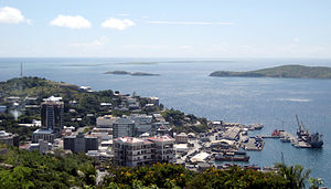

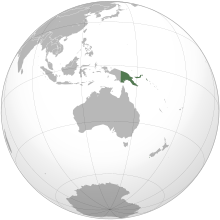
FlagLocation in Papua New Guinea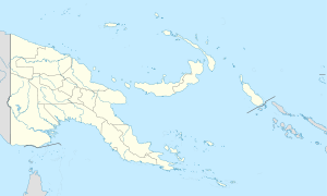
 Port Moresby
Coordinates: 9°25′S 147°17′E / 9.417°S 147.283°ECoordinates: 9°25′S 147°17′E / 9.417°S 147.283°E Country  Papua New Guinea
Province National Capital District Established 1873 Government - Governor Powes Parkop (2007-) Area - Total 92.7 sq mi (240 km2) Elevation 115 ft (35 m) Population (2009) - Total 307,643 - Density 3,320/sq mi (1,281.8/km2) Time zone AEST (UTC+10) Main languages Motu, Tok Pisin, English Port Moresby (
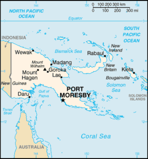
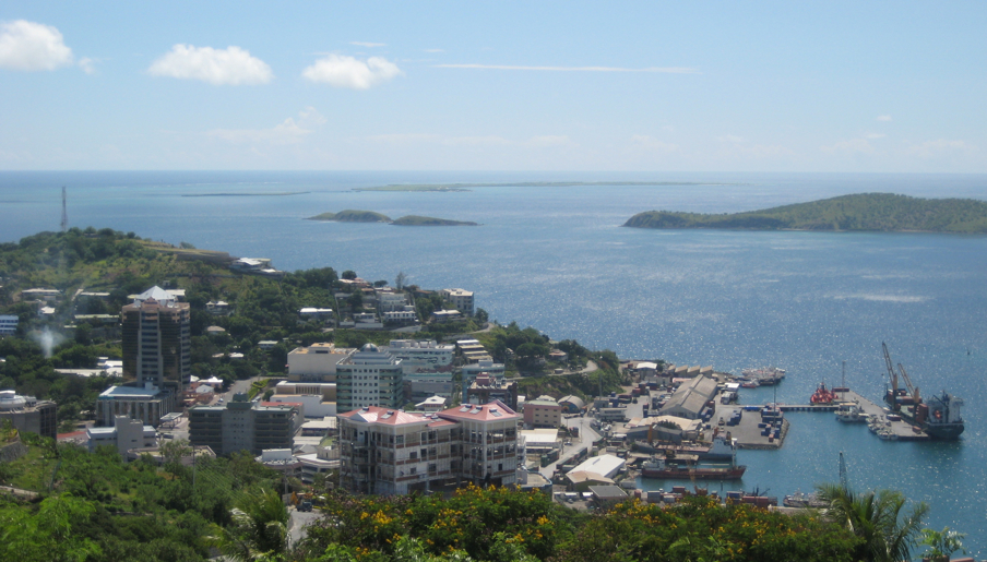
 /ˌpɔərt ˈmɔərzbi/), or Pot Mosbi in Tok Pisin, is the capital and largest city of Papua New Guinea (PNG). It is located on the shores of the Gulf of Papua, on the southeastern coast of the island of New Guinea, which made it a prime objective for conquest by the Imperial Japanese forces during 1942–43 in World War II, as a staging point and air base to cut off Australia from Southeast Asia and the Americas. In 2000 it had a population of 254,158.[1] As of 2009 it has a population of 307,643, giving it an annual growth rate of 2.1% over a nine year period.
The place where the city was founded has been inhabited by the Motu-Koitabu people for centuries. The first European to see it was Captain John Moresby in 1873. It was named in honour of his father Admiral Sir Fairfax Moresby.
According to a survey of world cities by the Intelligence Unit of The Economist, Port Moresby is one of the world's least livable cities (ranked 137 of 140 cities rated).[2]
Although Port Moresby is surrounded by Central Province, of which it is also the capital, it is not part of that province, but forms the National Capital District.
Contents
History
Before colonization
The Motuan people of the area now known as Port Moresby traded their pots for sago, other food and canoe logs, sailing from Hanuabada and other villages built on stilts above the waters of the bay. They also intermarried with the Gulf people and created strong family and trade links.[citation needed]
The Hiri expeditions were large scale. As many as 20 multi-hulled canoes or lakatoi, crewed by some 600 men, carried about 20,000 clay pots on each journey. To the Motuans, not only was the Hiri an economic enterprise but it also confirmed their tribal identity through its long and dangerous voyages. These voyages are commemorated in modern times by the annual Hiri Moale Festival held at Ela Beach in September.[citation needed]
Colonisation
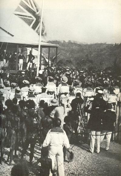
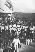 Queensland raises the British flag at Port Moresby 1883
There was already an important trade centre on the site of Port Moresby when the English Captain John Moresby of HMS Basilisk first visited it. He sailed through the Coral Sea at the eastern end of New Guinea, saw three previously unknown islands, and landed there. At 10 a.m. on 20 February 1873, he claimed the land for Britain and named it after his father, Admiral Sir Fairfax Moresby. He called the inner reach "Fairfax Harbour" and the other Port Moresby.[citation needed]
No Europeans settled there until ten years later, when the southeastern part of New Guinea was annexed to the British Empire. British New Guinea was transferred to the newly established Commonwealth of Australia in 1906, and became known as Papua. From then until 1941 Port Moresby grew slowly. The main growth was on the peninsula, where port facilities and other services were gradually improved. The first butcher's shop and grocery opened in 1909,[3] electricity was introduced in 1925,[4] and piped water supply provided in 1941.[5]
World War II and after
 The South West Pacific Area Theatre of operations in 1942–43 was operationally focused mainly on the shaded Papua half of New Guinea, and organizing forces for stopping the Japanese offensives southerly to Australia from their bases in the Solomon Islands and Solomon Sea just to the north and east of the Papua region.
During World War II, some Papuan men enlisted in the Papua Infantry Battalion, and others as carriers over trails and rough terrains (porters) as supply support to Allied and Japanese armies during long jungle marches.[6] The biographer of General Douglas MacArthur, noted historian William Manchester makes it plain in his seminal biography of the General, American Caesar, that acting as porters was well down the natives list of acceptable voluntary activities and that they would fade away without great inducements.[7] Many Papuan residents of Port Moresby either returned to their family villages or were evacuated to camps when the threat of Japanese invasion loomed. The city, while nominated to be abandoned to the Japanese in the spring by Australian factions was, by September, home to an important Allied complex of bases and thousands of troops were eventually stationed in the area or more often, staged through it, as it was the last allied bastion on the island and the last line of defense against the Japanese before Australia[8][9] and conversely, a key staging and jumping off point as the Allies got their feet underneath themselves under MacArthur, and began conducting offensive warfare themselves, pushing back the Japanese advances.[10] General George Kenney's outnumbered and out classed old fighters, when staged forward from new bases about Port Moresby, would effect Japanese decisions to withdraw from their beachhead on Milne Bay because the allied fighters were only minutes away and enjoyed a rapid turn around time to resume sweeps against long ranged Japanese air during the Battle of Milne Bay—and that earned Kenney a promotion for it was the first time Japanese aggression had been repulsed in any landing.
 The South West Pacific Area Command's Theatre in 1942 was mainly focused on Papua and the waters around it. MacArthur threatened to resign and so won the agreement by Australia's politicians to conduct a forward defense strategy.
Thus it was doubly a strategic target of the Japanese invasion fleet meant to conduct a direct sea-land amphibious assault in May 1942, but the invasion was prevented in the historic Battle of Coral Sea,[10] the first of five carrier versus carrier sea battles in mankinds' history. As long anticipated by MacArthur,[10] the Japanese kept trying to reach Port Moresby, for their strategic bid for air dominance by setting up a network of bases commanding the Sea lines of communication was obvious as was their desire to isolate and cut off Australia as a war aim. But with a mixed command he was reorganizing and training up on the fly (Many Australian units were drilling with wooden mockups of rifles in August of 1942[10]) before MacArthur's people could set up his planned defensive bases on the north coast of eastern Papua, the Japanese Army'd moved in and taken both north-coast villages he'd targeted for bases as reinforcements and war materials finally began to trickle in from the States in July— Buna and Gona— several weeks before the forces and transports his staff was organizing could have reached them[10] in strength—at a time when Japan's Navy and Air forces were dominant every where they chose to go.[10] The good news was some of those allocated forces were already forward at Milne Bay, where he was setting a trap with the veteran mid-East blooded 7th Australian Division, for he fully expected the Japanese would continue trans-coastal landings in an attempt to out flank Port Moresby, bringing ground forces in and around the point, in a end-around past the eastern tip of New Guinea and land on undefended beaches there. Once established, under cover from their air bases in the Solomon Sea they would be easy to resupply and hard to dislodge, and they could march overland to Port Moresby without negotiating mountains along the coast—in effect, the army would end up with terrain suitable for bombers to dominate the Coral Sea as they'd intended in landing in May when assaulting amphibiously from the Coral Sea.[10] Buna and Gona were their last successes in the New Guinea Campaign, for MacArthur's trap at the Battle of Milne Bay resulted in a see-saw battle that in the end had the Japanese abandon their beachhead and retreat for the first time in the war.[10] The Japanese then attempted to take the city by land over the Kokoda Track staging from Buna and Gona.
As Supreme Allied Commander of the South West Pacific Area], General Douglas MacArthur had after months of arguments with that victory, finally convinced Australian politicians in early August of 1942 to "defend Australia by defending Port Moresby"[10]—a forward defense strategy. During this period Port Moresby, especially its "villages", fell into disrepair as the Fifth Air Force under General George Kenney "pushed his bomber line forward 1800 miles"[10] rapidly establishing no less than five air bases around the sparsely populated town, and troops from a variety of nations under MacArthurs' direction transited through the vicinity; which became a major allied staging base feeding men and material forward from Brisbane, Australia which lies 1,800 miles across the Coral Sea and about six hours away by B-17 bomber or C-47 transport.[10] By the mid-September MacArthur established a Forward Head Quarters in Port Moresby, and by its end his staff was setting a lunch table in both Headquarters, so often was he splitting his time between locales.[10] With such a influx of non-natives and after the war the whole town had to be rebuilt.
In 1945, the Territory of Papua and New Guinea was formed when Papua and the former German New Guinea, which had been administered by Australia since 1918, were amalgamated under a single Australian administration. Port Moresby became the capital of the new combined territory and a focal point for the expansion of public services.
Capital city of an independent Papua New Guinea
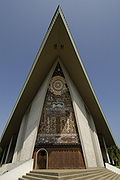 Front side of the parliament building.
In September 1975, Papua New Guinea became an independent country with Port Moresby as its capital city. New government buildings were constructed at Waigani to house government departments, including a National Parliament Building, which opened in 1984 and blends traditional design with modern building technology. The PNG National Museum and National Library are also located at Waigani.
Unfortunately, several of these government buildings have now been abandoned due to long-term neglect. Chief amongst these are Marea Haus (known to most locals as the "Pineapple Building") and the Central Government Offices. Nearby buildings such as Morauta Haus and Vulupindi Haus are now starting to show significant signs of decay due to a lack of maintenance, including crumbling fire stairs, grimy restrooms and elevators that are always out of service.
The population of the Port Moresby area expanded rapidly after independence. In 1980 the census registered 120,000; by 1990, this had increased to 195,000.
Climate
Port Moresby has a tropical wet and dry climate with relatively constant temperatures throughout the year. The wet season starts in December and ends in May; the dry season covers the remaining six months. Port Moresby's average yearly rainfall is just over 1000 mm. Average daily high temperatures range from 28°C to 32°C depending on time of year, while the average low temperature shows very little seasonal variation, hovering around the 24°C mark. It tends to be slightly cooler in the city during the dry season.
Climate data for Port Moresby, Papua New Guinea Month Jan Feb Mar Apr May Jun Jul Aug Sep Oct Nov Dec Year Record high °C (°F) 37
(99)36
(97)36
(97)36
(97)34
(93)33
(91)32
(90)32
(90)34
(93)34
(93)36
(97)36
(97)37
(99)Average high °C (°F) 32
(90)31
(88)31
(88)31
(88)30
(86)29
(84)28
(82)28
(82)29
(84)30
(86)31
(88)32
(90)30 Average low °C (°F) 24
(75)24
(75)24
(75)24
(75)24
(75)23
(73)23
(73)23
(73)23
(73)24
(75)24
(75)24
(75)24 Record low °C (°F) 21
(70)21
(70)21
(70)18
(64)21
(70)18
(64)19
(66)19
(66)19
(66)20
(68)21
(70)21
(70)18
(64)Precipitation mm (inches) 178
(7.01)193
(7.6)170
(6.69)107
(4.21)64
(2.52)33
(1.3)28
(1.1)18
(0.71)25
(0.98)36
(1.42)48
(1.89)112
(4.41)1,012
(39.84)Source: http://www.bbc.co.uk/weather/world/city_guides/results.shtml?tt=TT003090 Regions and suburbs
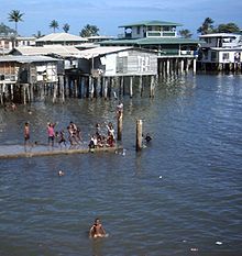 Koki neighbourhood
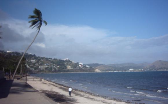
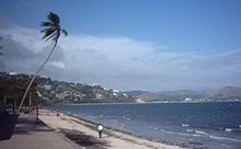 Ela Beach
Port Moresby refers to both the urbanised area of the National Capital District and more specifically to the main business area, known locally as "Town". Other neighbourhoods of Port Moresby include: Koki, with its popular fresh produce market, Newtown, Konedobu, Kaevaga, Badili, Gabutu, Kila Kila, Matirogo, Three Mile, Kaugere, Sabama, Korobosea, Four Mile, Hohola, Hohola North, Boroko, a major shopping area, Gordons, Gordons North, Erima, Saraga, Waigani, Morata and Gerehu. There are also villages like Hanuabada, the largest village in Papua New Guinea.
Transport
Port Moresby is served by Jacksons International Airport, the biggest international airport and Papua New Guinea Defence Force Air Wing base in the country. Air Niugini and Airlines PNG both conduct regular domestic and international services from the airport, while Pacific Blue Airlines flies to Brisbane.
Jacksons has international flights to Brisbane, Cairns, Sydney, Honiara, Nadi, Manila, Singapore, Hong Kong and Tokyo.
As the national highway system is not fully linked, there are many internal flights to other towns, e.g. Madang, which cannot be reached by ground transport, such as minibuses, known locally as PMVs (Public Motor Vehicles).
Economy
Airlines PNG has its head office on the grounds of Jacksons International Airport in Port Moresby.[11]
Twin towns
 Jinan, People's Republic of China (Province Shandong) since 28 September 1988
 Palm Desert, United States (California)
 Townsville, Australia (Queensland) since 1983
Associated town:
 Jayapura, Indonesia (Province Irian Jaya)
References
- ^ "citypopulation.de". citypopulation.de. http://www.citypopulation.de/PapuaNewGuinea.html. Retrieved 2010-04-25.
- ^ "Business | Vancouver is 'best place to live'". BBC News. 2005-10-04. http://news.bbc.co.uk/1/hi/business/4306936.stm. Retrieved 2010-04-25.
- ^ "March of Civilisation". The Argus (The Argus Office, Melbourne Victoria): p. 5. 7 September 1909. http://nla.gov.au/nla.news-article10731938. Retrieved 29 November 2009.
- ^ "Progress in Papua". The Argus (The Argus Office, Melbourne Victoria): p. 12. 5 September 1925. http://nla.gov.au/nla.news-article2133340. Retrieved 29 November 2009.
- ^ "Department of the Interior: Tenders". The Argus (The Argus Office, Melbourne Victoria): p. 18. 25 January 1941. http://nla.gov.au/nla.news-article8184170. Retrieved 29 November 2009.
- ^ "Australian War Memorial - AJRP Essays". Ajrp.awm.gov.au. http://ajrp.awm.gov.au/ajrp/ajrp2.nsf/5c2a7f65120f209aca256b6d0020a228/883ba42eefb9119aca256946001ef8ae?OpenDocument. Retrieved 2010-04-25.
- ^ American Caesar, William Manchester, 1978, Little Brown Company,793 pages, ISBN:0-316-54498-1, pp.306: On and about Jul-Sep 1942 and MacArthur's troops stop the Japanese in the difficult jungles of New Guinea and General Kenney gifts Port Moresby to the SAC by moving the bomber line 1800 miles to five new air bases.
- ^ "Amazon.com listing for the "Four Corners: A Journey into the Heart of Papua New Guinea"". http://www.amazon.com/dp/0792274172.
- ^ Salak, Kira. "Nonfiction book about Papua New Guinea,"Four Corners"". http://www.kirasalak.com/FourCorners.html.
- ^ a b c d e f g h i j k l American Caesar, William Manchester, 1978, Little Brown Company,793 pages, ISBN:0-316-54498-1, pp.290-307: On and about Feb-Dec 1942 and MacArthur's reorganization of troops, lack of theater priority, his support for Guadalcanal and his daring offensive gamble in going to meet the Japanese in the difficult jungles of New Guinea as a way of conducting a forward defense of Australia, rather than risk a war of maneuver when he had insufficient forces to move around.
- ^ "APNG Contacts." Airlines PNG. Retrieved on 26 May 2010.
External links
Provinces of Papua New GuineaBougainville1 · Central · Eastern Highlands · East New Britain · East Sepik · Enga · Gulf · Madang · Manus · Milne Bay · Morobe · New Ireland · Oro (Northern) · Sandaun (West Sepik) · Simbu (Chimbu) · Southern Highlands · Western · Western Highlands · West New Britain
National Capital District (Port Moresby)1 Autonomous region. Provincial capitals of Papua New Guinea Alotau (MB) · Arawa or Buka (Bougainville) · Daru (Western) · Goroka (EHP) · Kavieng (NI) · Kerema (Gulf) · Kimbe (WNB) · Kokopo (ENB) · Kundiawa (Simbu) · Lae (Morobe) · Lorengau (Manus) · Madang (Madang) · Mendi (SHP) · Mount Hagen (WHP) · Popondetta (Oro) · Port Moresby (Central/NCD) · Wabag (Enga) · Wewak (ES) · Vanimo (WS)
Capitals of Asia West and Southwest Asia Central Asia East Asia Abu Dhabi, United Arab Emirates (UAE)
Amman, Jordan
Ankara, Turkey 8
Baghdad, Iraq
Baku, Azerbaijan 8
Beirut, Lebanon
Damascus, Syria
Doha, Qatar
Episkopi, Akrotiri and Dhekelia 7
Jerusalem, proclaimed for both Israel and Palestine 6 7
Kabul, Afghanistan 1
Kuwait City, Kuwait
Manama, Bahrain
Muscat, Oman
Nicosia, Cyprus 7
Ramallah, Palestine Temporary
Riyadh, Saudi Arabia
Sana'a, Yemen
Tbilisi, Georgia 8
Tehran, Iran
Jerusalem, Israel
Yerevan, Armenia 7Ashgabat, Turkmenistan
Astana, Kazakhstan 8
Bishkek, Kyrgyzstan
Dushanbe, Tajikistan
Tashkent, UzbekistanSouth AsiaDhaka, Bangladesh
Islamabad, Pakistan
Kathmandu, Nepal
Kotte, Colombo, Sri Lanka 3
Malé, Maldives
New Delhi, India
Thimphu, BhutanBeijing, People's Republic of China (PRC)
Pyongyang, North Korea
Seoul, South Korea
Tokyo, Japan
Taipei, Republic of China (ROC) 2
Ulaanbaatar, Mongolia 1Southeast AsiaBandar Seri Begawan, Brunei
Bangkok, Thailand
Dili, East Timor 13
Hanoi, Vietnam
Jakarta, Indonesia
Kuala Lumpur 4 and Putrajaya,5 Malaysia
Manila, Philippines
Naypyidaw, Burma
Phnom Penh, Cambodia
Port Moresby, Papua New Guinea 9
Singapore, Singapore
Vientiane, Laos1 Often considered part of Central Asia. 2 Commonly known as Taiwan. 3 Full name is Sri Jayawardenapura Kotte.
4 Formal. 5 Administrative. 6 See Positions on Jerusalem for details on Jerusalem's status. 7 Entirely in Southwest Asia but having socio-political connections with Europe. 8 Transcontinental country. 9 Entirely in Melanesia but having socio-political connections with Southeast Asia. 13 Classified as Melanesia according to some definitions.Categories:- Provincial capitals in Papua New Guinea
- Port Moresby
- Capital districts and territories
- Gulf of Papua
- National Capital District (Papua New Guinea)
- Port cities in Oceania
- Populated places established in 1873


Wikimedia Foundation. 2010.