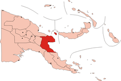
- Morobe Province
-
Coordinates: 6°50′S 146°40′E / 6.833°S 146.667°E
Morobe Province — Province — Country  Papua New Guinea
Capital Lae Government - Governor Luther Wenge (2002-) Area - Total 13,320.5 sq mi (34,500 km2) Population (2000) - Total 539,725 - Density 40.5/sq mi (15.6/km2) Time zone AEST (UTC+10) Morobe Province (previously named Adolfhafen in German New Guinea) is a province on the northern coast of Papua New Guinea. The provincial capital, and largest city, is Lae. The province covers 34,500 km², including 719 km² maritime area, with a population of 539,725 (2000 census). It includes the Huon Peninsula, the Markham River, and delta, and coastal territories along the Huon Gulf. The province has nine administrative districts, and 171 languages are spoken, including Kâte and Yabim. English and Pidgin English are common languages in the urban areas, and in some areas forms of Pidgin German are mixed with the native language.
Contents
History
World War II
See also: New Guinea campaignMorobe province was a key campaign site during World War II. The Japanese had established strong supply bases in the towns of Lae and Salamaua in 1942. The Salamaua-Lae campaign of the following year was a series of actions in which the Australian and United States forces sought to capture the two Japanese bases. The campaign to take the area began with the Australian attack on Japanese positions near Mubo, on 22 April 1943 and ended with the fall of Lae on 16 September 1943, in Operation Postern. The campaign was notable not only for its classic defense maneuvers at the Landing at Nadzab and the brutal hand-to-hand combat at Salamaua; Lyndon B. Johnson, the 36th President of the United States, saw his sole 13 minutes of combat on a bombing mission over Lae. Although the plane he was supposed to fly was shot down, with no survivors, his flight in B-26 Marauder had repercussions throughout the Pacific theater. Sent as an observer, with instructions to report up the line to Roosevelt, to Congress, and to the Navy brass that the conditions in the Pacific were deplorable, the men had third–rate equipment to fight Japan's first class planes. The effort needed another 6,800 trained and experienced men, plus better supplies, provisions, and generally a higher priority in the war effort.[1]
The Lae War Cemetery is located adjacent to the Botanical Gardens in the center of the city of Lae. The cemetery was begun in 1944 by the Australian Army Graves Services, and the Commonwealth Graves Commission assumed responsibility for it in 1947. The Lae Memorial commemorates 300 men of the Australian forces (including Merchant Navy, Royal Australian Air Force, and the Australian Army) who lost their lives and have no known grave. It contains 2300–2800 burials, of which 444 are unidentified.[2]
Ecology
Papua New Guinea is part of the Australasia ecozone. Through eco-tourism, the Province capitalizes on its spectacular scenery, readily accessible diving locales, and its mountains, and jungles to offer tourists rich experiences in coral reef, rain forest, sub-alpine and alpine and tropical habitats. The Province's jungles and forests are also popular for viewing over 1000 of species of birds and mammals, including the colourful Raggiana Bird of Paradise, the flightless Cassowary and varieties of macropods, including the Tree-kangaroo and over 15,000 species of plants. The Huon Peninsula, which comprises most of the provincial land-mass, is a unique montane eco-region that offers a variety of plants and conditions found nowhere else in the world. Its coral reefs and volcanic inlets are home to thousands of species of fish and oceanic life that thrive in the reefs and wrecks.
In 2009 the YUS Conservation Area has been established in the northern part of the Huon Peninsula. YUS streches over 760 km² and includes three rivers: Yopno, Uruwa and Som, after which it was named. It is a critical habitat for the endangered Matschie's Tree-kangaroo.[3]
Economy
See also: Economy of Papua New GuineaMorobe Province's economy has grown at the rate of approximately two percent per annum since 2006. The economic base of the Morobe Province depends on the production and harvesting of cocoa, coffee, copra and sugar, and tropical fruits (bananas, coconuts). Oil and gas industries are emerging, as is new mining and energy industry.[4] Deteriorating roads and the lack of manufacturing and transportation/communication infrastructure impedes economic development.[5]
Demographics
See also: Demographics of Papua New GuineaThe relative youth of the Morobe province population puts an increasing strain on schools and education services to combat illiteracy and its accompanying problems. Eight percent of the population (children) depend on twenty percent of the population (adults) for economic support, and population continues to grow at about 2.8 percent per year, which is higher than other developing countries.[5]
Languages
The population of Morobe speak over 171 languages, representing 27 language families. The two main languages are Kâte and Yabem, Kâte being spoken in the mountainous hinterlands and Yabem, on the coastal areas, particularly on the Huon peninsula coast. Along the coast and in the Markham Valley, the Austronesia family of languages predominate. The Papuan languages are heard most commonly in the mountain regions. English, and especially Pidgin English, are the common urban languages in Lae. In some areas, especially where the German missionaries maintained their Missions, such as Sattelberg and Finschhafen, pidgin German might be mixed with Kâte.
Government
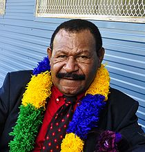
The Province sends nine members to the national parliament, and has 14 members of the Tutumang the provincial assembly. Tutumang means "the coming together," and the Province maintains that name for its assembly, as is permitted under the Organic Law on Provincial Government and Local Government.
Districts and LLGs
Each province in Papua New Guinea has one or more districts, and each district has one or more Local Level Government (LLG) areas. For census purposes, the LLG areas are subdivided into wards and those into census units.[6]
District District Capital LLG Name Bulolo District Bulolo Mumeng Rural Waria Rural Watut Rural Wau-Bulolo Urban Wau Rural Buang Rural Finschhafen District Gagidu Hube Rural Kotte Rural Finschafen Urban Yabim-Mape Rural Burum-Kuat Rural Huon District Salamaua Morobe Rural Salamaua Rural Wampar Rural Kabwum District Kabwum Deyamos Rural Komba (Seko) Rural Yus Rural Selepet Rural Lae District Lae Ahi Rural Lae Urban Markham District Kaiapit Onga-Waffa Rural Umi-Atzero Rural Wantoat-Leron Rural Menyamya District Menyamya Kapao Rural Nanima Kariba Kome Rural Wapi Rural Nawae District Boana Labuta Rural Nabak Rural Wain-Erap Rural Tewae-Siassi District Wasu Sialum Rural Siassi Rural Wasu Rural See also
References
- ^ Robert Dallek, Lone Star Rising, p. 237.
- ^ Digger Unofficial History, Lae War Cemetery. Accessed 13 September 2009.
- ^ Conservation International, retrieved 19 May 2010
- ^ Morobe Provincial Government, Economy and Industry. Accessed 14 September 2009.
- ^ a b Morobe Provincial Government, Issues. Accessed 14 September 2009.
- ^ National Statistical Office of Papua New Guinea
 Provinces of Papua New Guinea
Bougainville1 · Central · Eastern Highlands · East New Britain · East Sepik · Enga · Gulf · Madang · Manus · Milne Bay · Morobe · New Ireland · Oro (Northern) · Sandaun (West Sepik) · Simbu (Chimbu) · Southern Highlands · Western · Western Highlands · West New Britain
National Capital District (Port Moresby)1 Autonomous region. Categories:
Wikimedia Foundation. 2010.


