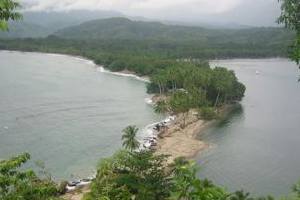
- Salamaua
Infobox PNG Place
type = village
name = Salamaua
province = mor
llg =
dot_x = 96
dot_y = 90

caption = Salamaua isthmus
pop =
lang =
langarea = Kela
elevation =
coor = coord|7|02|S|147|04|E|region:PG_type:city
maxtemp =
mintemp =
rainfall =
dist1 = 36
location1 = Lae
dir1 = SSESalamaua (German: "Samoahafen") was a small town situated on the north-eastern coastline of
Papua New Guinea part of Morobe province. The settlement was built on a minoristhmus between the coast with mountains on the inland side and a headland. The closest city isLae which can only be reached via boat across the gulf.History
In the 1920s prospective gold
miner s used Salamaua as a staging post to explore forgold in the inland areas. Gold was discovered atWau and miners came from all over and made for the goldfields via the roughBlack Cat Track .The town was captured by the
Japan ese in1942 duringWorld War II and later retaken byAustralia n andUnited States forces lead by GeneralDouglas MacArthur onSeptember 11 ,1943 during theSalamaua-Lae campaign . During reoccupation the town was destroyed.Today the villages of Kela and Lagui occupy the site as well as holiday houses, mainly for
expatriate s based in Lae.Early in 2007, a video production company from California explored the rain forests of Salamaua. The "
Destination Truth " expedition team was looking for theropen , a cryptid that is described in terms suggesting a Rhamphorhynchoid pterosaur. The explorers, including the leader Joshua Gates, videotaped a glowing flying object that seemed to correspond to local native ideas about the glowing ropen.
Wikimedia Foundation. 2010.
