- Kundiawa
Infobox PNG Place
type = town
name = Kundiawa
othername =
province = sim
llg = Kundiawa Urban
lang = English,Tok Pisin ,Kuman ,Dom ,Sinasina
langarea =Kuman
dot_x = 63
dot_y = 74

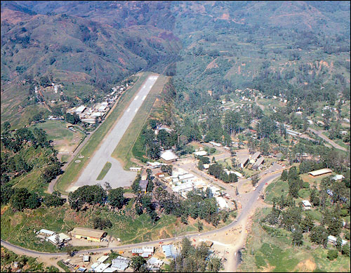
caption = Kundiawa aerial photograph.
pop = 8,147
popdate = 2000
poprank = 20th
est =
postcode =
elevation = 1524
coor = coord|6|01|S|144|58|E|region:PG_type:city
maxtemp =
mintemp =
rainfall =
dist1 =
location1 =Kundiawa is the capital of
Simbu Province ,Papua New Guinea , with a population of 8,147 (2000 Census). It lies along theHighlands Highway approximately halfway betweenGoroka andMount Hagen , respectively the capitals of the Eastern Highlands and Western Highlands provinces.It is a relatively small town, containing a bank, a police station, one of the few airports in the province, several stores, a hospital, a post office, a second-hand market, two food markets and several churches. The Highlands Highway is the only paved road that leads out of it, but there are several smaller, unpaved roads, including one of the roads to
Mount Wilhelm .Kundiawa is the center of activity for people who work (which is a relatively small minority, because most people farm) but also for people who want to sell the coffee that they have grown, or to catch
PMVs (public motor vehicles) to other towns. The busiest time in Kundiawa is every other Friday afternoon, because this is when everyone gets paid.The
Wahgi River runs along one side of Kundiawa, and theSimbu River , which runs on and becomes the Wahgi, flows along the other side. The terrain around Kundiawa is very steep and mountainous, and many people walk several kilometres each way to get to Kundiawa from their villages because they don't have access to roads.
Wikimedia Foundation. 2010.
