Kerema

Kerema

Infobox PNG Place
type = town
name = Kerema
othername =
province = gul
llg = Kerema Urban, Kerema Rural, East Karema Rural
lang = Tok Pisin, Toaripi
langarea = Toaripi
dot_x = 78
dot_y = 106


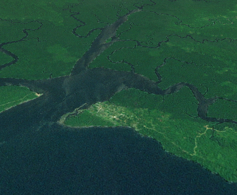
caption = A satellite image of Kerema
pop = 5,116
popdate = 2000
poprank = 25th
est =
postcode =
elevation = 6
coor = coord|7|58|S|145|46|E
maxtemp =
mintemp =
rainfall =
dist1 =
location1 =

Kerema is the capital of Gulf Province, Papua New Guinea. It is located on the coast of Gulf of Papua. The Gulf region is aptly named for its concave costline with large deltas. The Gulf area is a riparian region were many rivers from the southern slopes of the highlands drain into.

Culture and Tradition

The popular language spoken in Gulf Province is Torapi. The villages towards the East of Kerema from Hamuhamu to Iokea and inland to Moveave all speak Toaripi.The Gulf's traditional culture and knowledge was one of the first to be exposed to the outside world. Thus it was one of the first dying cultures, as outsiders mainly Christian missionaries have indoctrinated 80% of the coastal people to abandon most of their culture.

History

James Chalmers, or 'Tamate' as the locals of Toaripi called him, was the first white man to land in the province. He first landed in Iokea in 1885.

Industry

The Gulf area is blessed with many natural resources such as abundant marine life, rich jungle, sago, betelnut (buai), and many others. Currently oil explorations are showing positive results and it will be major income earner to the province. Fishing, logging and oil are the main industries, although betelnut and sago are the major cash crop for the local people. Gulf people supply 80% of the betelnut and sago to Port Moresby markets for cash.


Wikimedia Foundation. 2010.

Игры ⚽ Поможем сделать НИР

Look at other dictionaries:

  • Kerema — 7.9611111111111145.77222222222 Koordinaten: 7° 58′ S, 145° 46′ O …   Deutsch Wikipedia

  • Kerema — 7° 58′ S 145° 46′ E / 7.97, 145.77 …   Wikipédia en Français

  • Kerema — ▪ Papua New Guinea       minor port on the Gulf of Papua, south central Papua New Guinea, southwestern Pacific Ocean. Located on Kerema Bay, the town occupies hilly savanna land between the deltas of the Vailala and Lakekamu rivers. Rubber is… …   Universalium

  • Kerema — Original name in latin Kerema Name in other language KMA, Kerema State code PG Continent/City Pacific/Port Moresby longitude 7.96309 latitude 145.77851 altitude 18 Population 5646 Date 2012 01 16 …   Cities with a population over 1000 database

  • Kerema Airport — Infobox Airport name = Kerema Airport nativename = nativename a = nativename r = image width = caption = IATA = KMA ICAO = AYKM FAA = LID = type = Public owner = operator = owner oper = city served = location = Kerema, Papua New Guinea elevation… …   Wikipedia

  • Bistum Kerema — Basisdaten Staat Papua Neuguinea Metropolitanbistum Erzbistum Port Moresby …   Deutsch Wikipedia

  • Roman Catholic Diocese of Kerema — The Roman Catholic Diocese of Kerema is a suffragan diocese of the Roman Catholic Archdiocese of Port Moresby. It was erected in 1971 from separated parts of the Dioceses of Bereina and Mendi. Bishops*Virgil Patrick Copas, M.S.C., Ordinary,… …   Wikipedia

  • Gulf (Papua-Neuguinea) — Gulf (Goeland) Geographie Staat: Papua Neuguinea Gewässer: Pazifischer Ozean …   Deutsch Wikipedia

  • Districts and LLGs of Papua New Guinea — Districts and LLGs of Papua New Guinea …   Wikipedia

  • Paul John Marx — MSC (* 12. März 1935 in Mutzig) ist Altbischof von Kerema. Leben Paul John Marx trat der Ordensgemeinschaft der Herz Jesu Missionare bei und empfing am 29. Juni 1963 die Priesterweihe. Papst Johannes Paul II. ernannte ihn am 3. Mai 1985 zum… …   Deutsch Wikipedia

Share the article and excerpts

Direct link
Do a right-click on the link above
and select “Copy Link”