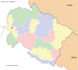
- Chamoli Gopeshwar
-
Gopeshwar
गोपेश्वर
— city — Coordinates 30°25′N 79°20′E / 30.42°N 79.33°ECoordinates: 30°25′N 79°20′E / 30.42°N 79.33°E Country India State Uttarakhand District(s) Chamoli Population 19,855 (2001[update]) Time zone IST (UTC+05:30) Area
• 1,293 metres (4,242 ft)
Website 210.212.78.56/50cities/gopeshwar/english/home.asp Chamoli Gopeshwar (Hindi: चमोली गोपेश्वर) or Gopeshwar (Hindi: गोपेश्वर) is a town in Chamoli district in the state of Uttarakhand, India. It is the administrative headquarters of the Chamoli District of Uttarakhand in India. Located 1300 meters above sea level, it is famous for its weather (pleasant most of the year, but very cold in December and January) and its temples.
Contents
Geography
Gopeshwar is located at 30°25′N 79°20′E / 30.42°N 79.33°E.[1] It has an average elevation of 1,293 metres (4,242 feet).
Demographics
As of 2001[update] India census,[2] Chamoli Gopeshwar had a population of 19,855. Males constitute 56% of the population and females 44%. Chamoli Gopeshwar has an average literacy rate of 81%, higher than the national average of 59.5%; with male literacy of 85% and female literacy of 75%. 10% of the population is under 6 years of age.
Places of interest
Gopeshwar is surrounded by four famous temples: Tungnath, Anusuya Devi, Rudranath, and Badrinath. The holy town of Kedarnath is also nearby.
A famous temple of Lord Shiva, now known as Gopinath Mandir, is situated here. A story tells of a king named Sagar (for whom a nearby village is named) who was there in ancient times. His cow always came to this place and gave his milk to a Shivling; one day Sagar saw it and he constructed a temple there.
References
- ^ Falling Rain Genomics, Inc - Gopeshwar
- ^ "Census of India 2001: Data from the 2001 Census, including cities, villages and towns (Provisional)". Census Commission of India. Archived from the original on 2004-06-16. http://web.archive.org/web/20040616075334/http://www.censusindia.net/results/town.php?stad=A&state5=999. Retrieved 2008-11-01.
Four km from the village SAGAR is situating. People say that KING SAGAR's birthday place here. From village SAGAR the way to heaven RUDRANATH.
External links
Cities and towns in Chamoli district Chamoli Auli · Badrinath · Chamoli Gopeshwar · Gochar · Govindghat · Gwaldam · Jyotirmath · Karnaprayag · Mana · Nandaprayag · Vishnuprayag
Cities and towns
in other districtsAlmora · Bageshwar · Champawat · Dehradun · Haridwar · Nainital · Pauri Garhwal · Pithoragarh · Rudraprayag · Tehri Garhwal · Udham Singh Nagar · Uttarkashi
Municipalities of Uttarakhand Municipal
CorporationsMunicipalities Almora · Bageshwar · Bajpur · Bhowali · Chamoli Gopeshwar · Dogadda · Gadarpur · Jaspur · Jyotirmath · Kashipur · Khatima · Kichha · Kotdwara · Manglaur · Mussoorie · Nainital · Narendra Nagar · Pauri · Pithoragarh · Ramnagar · Rishikesh · Roorkee · Rudraprayag · Rudrapur · Sitarganj · Srinagar · Tanakpur · Tehri · Uttarkashi · Vikasnagar
Nagar
PanchayatsBadrinathpuri · Barkot · Bhimtal · Chamba · Champawat · Dev Prayag · Dharchula · Didihat · Dineshpur · Doiwala · Dwarahat · Gangotri · Gochar · Herbertpur · Jhabrera · Kaladungi · Karnaprayag · Kedarnath · Kela Khera · Kirtinagar · Laksar · Lalkuan · Landaura · Lohaghat · Mahua Dabra Haripura · Mahua Kheraganj · Muni Ki Reti · Nandprayag · Shaktigarh · Sultanpur
[[newSAGARी गोपेश्वर SAGAR ]]
Categories:- Cities and towns in Chamoli district
- Uttarakhand geography stubs
Wikimedia Foundation. 2010.


