- Seraikela Kharsawan district
-
Seraikela-Kharsawan district
सराइकेला खरसावाँ जिला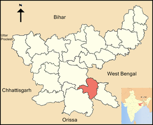
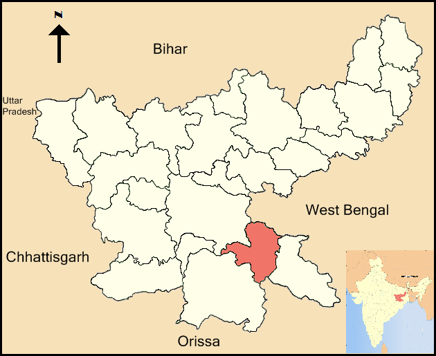
Location of Seraikela-Kharsawan district in JharkhandState Jharkhand,  India
IndiaAdministrative division Kolhan division Headquarters Seraikela Area 2,724.55 km2 (1,051.95 sq mi) Population 848,850 (2001) Population density 312 /km2 (810 /sq mi) Urban population 16.30% Literacy 50.7% Sex ratio 987 Lok Sabha Constituencies 1. Ranchi (shared with Ranchi district, 2. Singhbhum (shared with West Singhbhum district and 3. Khunti (shared with Khunti district) Assembly Seats 3 Average annual precipitation 1350 mm Official website Seraikela-Kharsawan district (Hindi: सराइकेला खरसावाँ जिला); formerly the princely state of Seraikella/Saraikella is one of the twenty-four districts of Jharkhand state in eastern India. Seraikela town is the district headquarters of Saraikela Kharsawan district. The district is well-known for Seraikela Chhau, one of the three distinctive styles of the chhau dance. This district was carved out from West Singhbhum district in 2001.
Contents
History
Royalty
Members of the erstwhile royal family of Seraikella, the Singh Deo family (patrons of the Chau dance), divide their time between The Palace, Seraikella-833219; a 300 year old heritage palace and historical landmark and their residences in Orissa, West Bengal and abroad. The last ruler of the Seraikella princely state was HH Raja Aditya Pratap Singh Deo (son of HH Maharaja Udit Narayan Singh Deo) and notables of the era include his sons Tikayet Sahib Nrupendra Narayan Singh Deo, HH Maharaja Sir Rajendra Narayan Singh Deo(given in adoption to Patna-Bolangir state, former Chief Minister of Orissa), Patayet Sahib Maharajkumar Bhoopendra Narayan Singh Deo(leading regional politician who supported the popular tribal anti-merger movement with Bihar) and Rajkumar Sudhendra Narayan Singh Deo(Param-Guru of Chau), a Padma Shree awardee.
The Singh Deo royal family remains active in public life(political, cultural and religious)and act as guardians to the Ma Paudi temple located within the Royal residence, host the annual Chau Festival at the Seraikella Royal Palace and retain a hold on the region's real-estate and business. Despite their loss of formal title and privileges, they enjoy public support in the area(comprising the former Seraikella state). Notable members of the royal family who remain active in the public eye include Rajkumar Pratap Aditya Singh Deo, Rajkumar Juga Bhanu Singh Deo,Maharajkumar Jairaj Singh Deo and Rajkumar Rajvikram Singh Deo
Recent events
The district is currently a part of the Red Corridor.[1]
Geography
The district is situated between 22°29'26" and 23°09'34" north latitudes and 85°30'14" and 86°15'24" east longitudes.
Economy
In 2006 the Ministry of Panchayati Raj named Seraikela Kharsawan one of the country's 250 most backward districts (out of a total of 640).[2] It is one of the 21 districts in Jharkhand currently receiving funds from the Backward Regions Grant Fund Programme (BRGF).[2]
Divisions
The district comprises 8 blocks: Seraikela, Kharsawan, Gamharia, Kuchai, Ichagarh, Nimdih, Chandil and Rajnagar.
There are three Vidhan Sabha constituencies in this district: Ichagarh, Seraikela and Kharsawan. These are parts of Ranchi, Singhbhum and Khunti Lok Sabha constituencies respectively.
Demographics
According to the 2011 census Seraikela Kharsawan district has a population of 1,063,458 ,[3] roughly equal to the nation of Cyprus[4] or the US state of Rhode Island.[5] This gives it a ranking of 428th in India (out of a total of 640).[3] The district has a population density of 390 inhabitants per square kilometre (1,000 /sq mi) .[3] Its population growth rate over the decade 2001-2011 was 25.28 %.[3] Saraikela Kharsawan has a sex ratio of 958 females for every 1000 males,[3] and a literacy rate of 68.85 %.[3]
References
- ^ "83 districts under the Security Related Expenditure Scheme". IntelliBriefs. 2009-12-11. http://intellibriefs.blogspot.com/2009/12/naxal-menace-83-districts-under.html. Retrieved 2011-09-17.
- ^ a b Ministry of Panchayati Raj (September 8, 2009). "A Note on the Backward Regions Grant Fund Programme". National Institute of Rural Development. http://www.nird.org.in/brgf/doc/brgf_BackgroundNote.pdf. Retrieved September 27, 2011.
- ^ a b c d e f "District Census 2011". Census2011.co.in. 2011. http://www.census2011.co.in/district.php. Retrieved 2011-09-30.
- ^ US Directorate of Intelligence. "Country Comparison:Population". https://www.cia.gov/library/publications/the-world-factbook/rankorder/2119rank.html. Retrieved 2011-10-01. "Cyprus 1,120,489 July 2011 est."
- ^ "2010 Resident Population Data". U. S. Census Bureau. http://2010.census.gov/2010census/data/apportionment-pop-text.php. Retrieved 2011-09-30. "Rhode Island 1,052,567"
External links

Ranchi district Purulia district, West Bengal Khunti district 
 Seraikela Kharsawan district

West Singhbhum district Mayurbhanj district, Orissa East Singhbhum district Blocks of Seraikela Kharsawan district Blocks Chandil · Gamaharia · Ichagarh · Kharsawan · Kuchai · Nimdih · Rajnagar · SeraikelaDivisions and Districts of Jharkhand, India South Chotanagpur division North Chotanagpur division Palamu division Santhal Pargana division Kolhan division Cities and towns in Kolhan division East Singhbhum district Bagbera • Baharagora • Chakulia • Chhota Gobindpur • Gadhra • Ghatshila • Ghorabandha • Haludbani • Jadugora • Jamshedpur • Jugsalai • Kokpara • Mahulia • Mango • Musabani • SarjamdaSeraikela Kharsawan district West Singhbhum district Barajamda • Chaibasa • Chakradharpur • Chiria • Danguwapasi • Gua • Jhinkpani • Kalikapur • Kandra • Kiriburu • Meghahatuburu • Noamundi • Porahat • SiniRelated topics Kolhan Division topicsCities and towns
in other DivisionsKolhan division topics General Districts Seraikela Kharswan • East Singhbhum • West SinghbhumRivers, Waterfalls, Dams Languages, people Transport National Highway 6 • National Highway 32 • National Highway 33 • South Eastern Railway • Sonari Airport • Tatanagar Railway StationIndustries Institutes of higher learning Lok Sabha constituencies Vidhan Sabha constituencies Jamshedpur Baharagora • Ghatsila • Potka • Jugsalai • Jamshedpur East • Jamshedpur West Singhbhum Seraikella • Chaibasa • Majhgaon • Jaganathpur • Manoharpur • ChakradharpurSee also Cities and towns in Kolhan Division • Villages in Seraikela Kharswan district • Villages in East Singhbhum district • Mahanadi-Brahmani-Bitarani Basin • Jamshedpur topicsOther Divisions North Chotangapur • South Chaotanagpur • Palamu • Santhal ParganaCategories:- Districts of Jharkhand
- Seraikela Kharsawan district
- Jharkhand geography stubs
Wikimedia Foundation. 2010.