- Dumka district
-
This article is about the district. For its eponymous headquarters, see Dumka.
Dumka district
दुमका जिला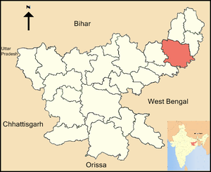
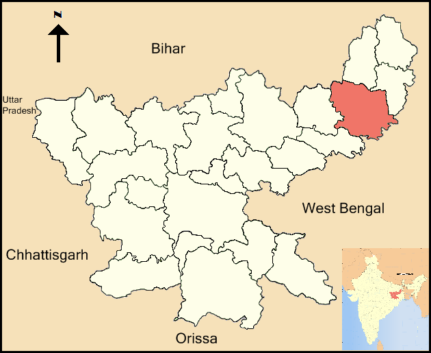
Location of Dumka district in JharkhandState Jharkhand,  India
IndiaAdministrative division Santhal Pargana Division Headquarters Dumka Area 3,716 km2 (1,435 sq mi) Population 1,106,521 (2001) Population density 298 /km2 (770 /sq mi) Literacy 48.31 per cent[1] Lok Sabha Constituencies Dumka Assembly Seats 4 Official website Dumka district (Hindi: दुमका जिला) is one of the twenty-four districts of Jharkhand state in eastern India, and Dumka is the administrative headquarters of this district. This district covers an area of 3716.02 km². This district has a population of 1,106,521 (2001 Census).
Contents
Economy
In 2006 the Indian government named Dumka one of the country's 250 most backward districts (out of a total of 640).[2] It is one of the 21 districts in Jharkhand currently receiving funds from the Backward Regions Grant Fund Programme (BRGF).[2]
Divisions
The district comprises only one sub-division, Dumka and it consists 10 blocks: Dumka, Gopikander, Jama, Jarmundi, Kathikund, Maslia, Ramgarh, Raneshwar, Shikaripara and Saraiyahat.
There are four Vidhan Sabha constituencies in this district: Sikaripara, Dumka, Jama and Jarmundi. All of these are part of Dumka Lok Sabha constituency. Dumka is one of the beautiful city in India.. in other words it is also called as mini KOLKATA.
Demographics
According to the 2011 census Dumka district has a population of 1,321,096,[3] roughly equal to the nation of Mauritius[4] or the US state of New Hampshire.[5] This gives it a ranking of 370th in India (out of a total of 640).[3] The district has a population density of 300 inhabitants per square kilometre (780 /sq mi) .[3] Its population growth rate over the decade 2001-2011 was 19.39 %.[3] Dumka has a sex ratio of 974 females for every 1000 males,[3] and a literacy rate of 62.54 %.[3]
Education
On 10 January 1992 Siddhu Kanhu University was founded in Dumka, which, later, on 6 May 2003 renamed as Sido Kanhu Murmu University. This university has 13 constituent colleges, which include Santal Pargana College (founded in 1955) and S.P. Mahila College (founded in 1974).
References
- ^ "District-specific Literates and Literacy Rates, 2001". Registrar General, India, Ministry of Home Affairs. http://www.educationforallinindia.com/page157.html. Retrieved 2010-10-10.
- ^ a b Ministry of Panchayati Raj (September 8, 2009). "A Note on the Backward Regions Grant Fund Programme". National Institute of Rural Development. http://www.nird.org.in/brgf/doc/brgf_BackgroundNote.pdf. Retrieved September 27, 2011.
- ^ a b c d e f "District Census 2011". Census2011.co.in. 2011. http://www.census2011.co.in/district.php. Retrieved 2011-09-30.
- ^ US Directorate of Intelligence. "Country Comparison:Population". https://www.cia.gov/library/publications/the-world-factbook/rankorder/2119rank.html. Retrieved 2011-10-01. "Mauritius 1,303,717 July 2011 est."
- ^ "2010 Resident Population Data". U. S. Census Bureau. http://2010.census.gov/2010census/data/apportionment-pop-text.php. Retrieved 2011-09-30. "New Hampshire 1,316,470"

Banka district, Bihar Godda district Deoghar district 
Pakur district  Dumka district

Jamtara district Birbhum district, West Bengal Divisions and Districts of Jharkhand, India South Chotanagpur division North Chotanagpur division Palamu division Santhal Pargana division Kolhan division Cities and towns in Santhal Parganas Deoghar district Dumka district Godda district Godda • Lalmatia CollieryJamtara district Pakur district Sahebganj district Related topics Santhal Pargana Division topicsCities and towns
in other DivisionsSanthal Pargana division topics General Santhal rebellion • Vaidyanath Jyotirlinga, Deogarh • Damin-i-kohDistricts Community development blocks Rivers, Waterfalls, Dams Languages, people Transport Institutes of higher learning Sido Kanhu Murmu UniversityLok Sabha constituencies Vidhan Sabha constituencies See also Cities and towns in Santhal Parganas Division • Villages in Dumka districtOther Divisions North Chotangapur • South Chaotanagpur • Kolhan • PalamuCategories:- Districts of Jharkhand
- Dumka district
- Jharkhand geography stubs
Wikimedia Foundation. 2010.