- Chatra district
-
This article is about the district. For its eponymous headquarters, see Chatra.
Chatra district
चतरा जिला
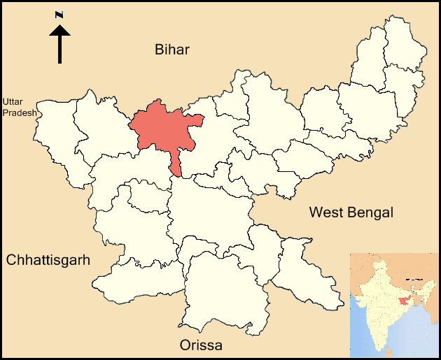
Location of Chatra district in JharkhandState Jharkhand,  India
IndiaAdministrative division North Chotanagpur division Headquarters Chatra Area 3,706 km2 (1,431 sq mi) Population 790,680 (2001) Population density 213 /km2 (550 /sq mi) Urban population 05.31 Literacy 43.35 per cent[1] Sex ratio 964 Lok Sabha Constituencies Chatra (shared with Palamu and Latehar districts) Assembly Seats 2 Official website Chatra district (Hindi: चतरा जिला) is one of the twenty-four districts of Jharkhand state, India, and Chatra is the administrative headquarters of this district. The district covers an area of 3706 km². It has a population of 790,680 (Census 2001).
Contents
History
The territory covered by the present district was earlier known as Chatra sub-division of Hazaribagh district. This district came into existence in 1991.
Ancient period
In ancient period, the area covered by the present district and adjoining areas were ruled by a number of states, which were collectively known as the Atavika (forest) states. These states accepted the suzerainty of the Maurya empire during Ashoka's reign (c.232 BCE). Samudragupta, while marching through the present-day Chotanagpur region, directed the first attack against the kingdom of Dakshina Kosala in the Mahanadi valley.[2]
Medieval period
During Muhammad bin Tughluq's reign, the territory which comprises the present district came in contact with the Delhi sultanate. Later, it became a part of the Bihar Subah of the Mughal empire. Daud Khan, the Mughal Subahdar of Bihar, during the reign of Aurangzeb occupied Kothi Fort on 5 May 1660, without much opposition, and then he moved towards the fort of Kunda which had a very strong fortification as it was situated on a hilltop. This fort was finally occupied by him and was completely destroyed on the 2 June 1660. Later, Kunda Fort was under the possession of the Raja of Ramgarh. In 1734, Aliwardi Khan advanced towards Kunda after defeating the rebel Zamindars of Tikari (Gaya). He mounted an attack on Chatra Fort and demolished it.[2]
British rule
The British East India Company came in contact with this region for the first time in 1769. Raja Ram Mohan Roy, worked as a serestadar at Chatra from 1805–06 and stayed both at Chatra and Ramgarh while in office.[2]
The most important battle fought between the insurgents and the British in Chotanagpur during the rebellion of 1857 was the "Battle of Chatra". This decisive battle was fought on 2 October 1857 near Phansi Talab. It lasted for an hour in which the mutineers were completely defeated. 56 Europeon soldiers and officers were killed whereas 150 revolutionaries were killed and 77 were buried in a pit. Subedar Jai Mangal Pandey and Nadir Ali Khan were sentenced and hanged to death on the 4 October 1857 on this very spot. The European and sikh soldiers were buried in a well along with their arms and ammunitions. An inscriptive plaque which is still extant states:
"56 men of Her Majesty's 53rd Regiment of foot and a party of Sikhs were killed at Chatra on October 2nd 1857 in action against mutineers of the Ramgarh Battalion. Lieutenant J. C. C. Daunt of the 70th Bengal Native Infantry and sergeant D. Dynon of the 53rd regiment were awarded Victoria Cross for conspicuous gallantry in the battle, in which the mutineers were completely defeated and lost all their four guns and ammunitions.
At the same time, another inscription on the bank of the Phansi Talab immortalises the two revolutionary subedars,[2] namely, Mangal Pandey and Nadir Ali Khan.
Independence movement
The independence movement in this district gathered momentum in 1921. One of the most significant events of the Quit India Movement in 1942, was the escape of Jai Prakash Narayan along with six other from The Hazaribagh Central Jail on 9 November 1942 (the night of festival of Diwali). Jai Prakash Narayan came to Tatra (a village in this district), and then proceeded towards Sherghati en route to Varanasi. The notable participants in the independence movement from this district include Chotanagpur Kesri, Babu Ram Narayan Singh, and Babu Shaligram Singh.[2]
Post-independence
The district is currently a part of the Red Corridor.[3]
Economy
In 2006 the Indian government named Chatra one of the country's 250 most backward districts (out of a total of 640).[4] It is one of the 21 districts in Jharkhand currently receiving funds from the Backward Regions Grant Fund Programme (BRGF).[4]
Demographics
According to the 2011 census Chatra district has a population of 1,042,304,[5] roughly equal to the nation of Cyprus[6] or the US state of Rhode Island.[7] This gives it a ranking of 434rd in India (out of a total of 640).[5] The district has a population density of 275 inhabitants per square kilometre (710 /sq mi) .[5] Its population growth rate over the decade 2001-2011 was 28.98 %.[5] Chatra has a sex ratio of 951 females for every 1000 males,[5] and a literacy rate of 62.14 %.[5]
References
- ^ "District-specific Literates and Literacy Rates, 2001". Registrar General, India, Ministry of Home Affairs. http://www.educationforallinindia.com/page157.html. Retrieved 2010-10-10.
- ^ a b c d e "History". Chatra district website. http://chatra.nic.in/history.htm.
- ^ "83 districts under the Security Related Expenditure Scheme". IntelliBriefs. 2009-12-11. http://intellibriefs.blogspot.com/2009/12/naxal-menace-83-districts-under.html. Retrieved 2011-09-17.
- ^ a b Ministry of Panchayati Raj (September 8, 2009). "A Note on the Backward Regions Grant Fund Programme". National Institute of Rural Development. http://www.nird.org.in/brgf/doc/brgf_BackgroundNote.pdf. Retrieved September 27, 2011.
- ^ a b c d e f "District Census 2011". Census2011.co.in. 2011. http://www.census2011.co.in/district.php. Retrieved 2011-09-30.
- ^ US Directorate of Intelligence. "Country Comparison:Population". https://www.cia.gov/library/publications/the-world-factbook/rankorder/2119rank.html. Retrieved 2011-10-01. "Cyprus 1,120,489 July 2011 est."
- ^ "2010 Resident Population Data". U. S. Census Bureau. http://2010.census.gov/2010census/data/apportionment-pop-text.php. Retrieved 2011-09-30. "Rhode Island 1,052,567"
External links

Gaya district, Bihar Palamu district 
Hazaribagh district  Chatra district

Latehar district Ranchi district Divisions and Districts of Jharkhand, India South Chotanagpur division North Chotanagpur division Palamu division Santhal Pargana division Kolhan division North Chotanagpur division topics General Hazaribagh National Park • Ramgarh Raj • Chota Nagpur Plateau • Shikharji • Parasnath Hills • Surajkund hot spring • Damodar Valley CorporationDistricts Community development blocks Bokaro district Bermo • Chandankiyari • Chas • Gomia • Jaridih • Kasmar • Nawadih • Petarwar Giridih district Bagodar • Bengabad • Birni • Deori • Dumri • Gandey • Gawan • Giridih • Pirtand • Tisari Hazaribagh district Barkatha • PadmaRivers, Waterfalls, Dams Barakar • Bokaro • Damodar • Jamunia • Konar • Lilajan/Niranjana • Mohana • Kiul • Punpun • Rajrappa • Usri Falls • Tilaiya Dam • Konar Dam • Tenughat Dam • Maithon Dam • Panchet DamLanguages, people Transport National Highway 2 • Grand Trunk Road • National Highway 31 • National Highway 32 • National Highway 33 • National Highway 99 • National Highway 100 • Howrah-Delhi main line • Grand Chord • East Central Railway • South Eastern RailwayRailway stations Hazaribagh RoadCoalfields and coal companies South Karanpura Coalfield • North Karanpura Coalfield • Ramgarh Coalfield • West Bokaro Coalfield • East Bokaro Coalfield • Bharat Coking Coal Limited • Central Coalfields LimitedIndustries Bokaro Steel Plant • Bokaro Thermal Power Station BInstitutes of higher learning Vinoba Bhave University • Indian School of MinesLok Sabha constituencies Vidhan Sabha constituencies See also Cities and towns in North Chotanagpur Division • Villages in Bokaro district • Villages in Dhanbad district • Villages in Giridih district • Villages in Hazaribagh district • Damodar ValleyOther Divisions South Chotangapur • Kolhan • Palamu • Santhal ParganaHindu Temples in Jharkhand Deoghar Vaidyanath Jyotirlinga, DeogarhRanchi Categories:
Wikimedia Foundation. 2010.