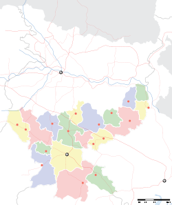
- Chatra, Jharkhand
-
Chatra — town — Coordinates 24°12′16″N 84°52′37″E / 24.2045100°N 84.8770400°ECoordinates: 24°12′16″N 84°52′37″E / 24.2045100°N 84.8770400°E Country India State Jharkhand District(s) Chatra Parliamentary constituency Chatra Assembly constituency Chatra Population 41,990 (2001[update]) Time zone IST (UTC+05:30) Website chatra.nic.in/ Chatra (Hindi: चतरा) is headquarters of Chatra district in the Indian state of Jharkhand.
Contents
Geography
Chatra is located at 24°12′16″N 84°52′37″E / 24.2045100°N 84.8770400°E.
Chatra has several waterfalls around it: Gua Falls (6 km), Keridah Falls (8 km), Maludah Falls (8 km), and Bichkiliya (11 km). Balbal Duari (25 km) has a hot spring.[1]
History
Raja Ram Mohan Roy, the prominent social reformer, worked as a Sirishtedar at Chatra in 1805-06 and lived both at Chatra and Ramgarh in this capacity.[2]
Demographics
In 2001 census, Chatra had a population of 41,990, out of which 22,331 were males and 19,659 were females. 27,409 persons were literate.[3]
Transport
Chatra stands at the crossing of NH 99 and NH 100.
References
- ^ "Exploring Jharkhand". Jharkhand4u. http://www.jharkand4u.com/explore/waterfalls.html. Retrieved 2010-04-29.
- ^ "History of Chatra district". Government of Jharkhand. http://chatra.nic.in/history.htm. Retrieved 2010-04-09.
- ^ "Census of India 2001". Table - 3 : Population, population in the age group 0-6 and literates by sex - Cities/Towns (in alphabetic order): 2001. Archived from the original on 2004-06-16. http://web.archive.org/web/20040616075334/http://www.censusindia.net/results/town.php?stad=A&state5=999. Retrieved 2010-04-09.
Categories:- Cities and towns in Chatra district
- Jharkhand geography stubs
Wikimedia Foundation. 2010.


