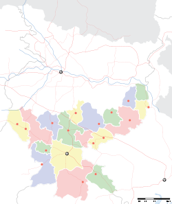
- Meru, Hazaribagh
-
Meru — city — Coordinates 24°1′46″N 85°27′26″E / 24.02944°N 85.45722°ECoordinates: 24°1′46″N 85°27′26″E / 24.02944°N 85.45722°E Country India State Jharkhand District(s) Hazaribagh Population 8,547 (2001[update]) Time zone IST (UTC+05:30) Meru is a census town in Hazaribagh district in the Indian state of Jharkhand. It is located on the Hazaribagh- Bagodar road (National Highway 100).
Contents
Geography
It is located at 24°1′46″N 85°27′26″E / 24.02944°N 85.45722°E.[1]
Demographics
As of 2001[update] India census[2], Meru had a population of 8,547. Males constitute 66% of the population and females 34%. Meru has an average literacy rate of 75%, higher than the national average of 59.5%: male literacy is 86%, and female literacy is 55%. In Meru, 12% of the population is under 6 years of age.
BSF Centre
Meru has a BSF training centre and school for advance training of counter insurgency, counter terrorism and bomb disposal.[3]
References
- ^ http://wikimapia.org/#lat=24.0295324&lon=85.4574537&z=16&l=0&m=a&v=2 Wikimapia
- ^ "Census of India 2001: Data from the 2001 Census, including cities, villages and towns (Provisional)". Census Commission of India. Archived from the original on 2004-06-16. http://web.archive.org/web/20040616075334/http://www.censusindia.net/results/town.php?stad=A&state5=999. Retrieved 2008-11-01.
- ^ "Excellence tag for BSF training centre". The Telegraph, 13 September 2009. http://www.telegraphindia.com/1090913/jsp/jharkhand/story_11487477.jsp. Retrieved 2010-04-17.
External links
Categories:- Cities and towns in Hazaribagh district
- Jharkhand geography stubs
Wikimedia Foundation. 2010.


