- Dogadda
-
Dogadda — city — Coordinates 29°48′N 78°37′E / 29.80°N 78.62°ECoordinates: 29°48′N 78°37′E / 29.80°N 78.62°E Country India State Uttarakhand District(s) Pauri Garhwal Population 2,690 (2001[update]) Time zone IST (UTC+05:30) Area
• 932 metres (3,058 ft)
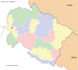
Dogadda or Dugadda(दोगड्डा) is a city and a municipal board in Pauri Garhwal District in the state of Uttarakhand, India. Dogadda is a small town which is surrounded by mountains.
Contents
Geography
Dogadda is located at 29°48′N 78°37′E / 29.80°N 78.62°E.[1] It has an average elevation of 932 metres (3,058 feet).
Demographics
As of 2001[update] India census[2], Dogadda had a population of 2690. Males constitute 54% of the population and females 46%. Dogadda has an average literacy rate of 78%, higher than the national average of 59.5%: male literacy is 82% and, female literacy is 74%. In Dogadda, 13% of the population is under 6 years of age.
History
Before emergence of Kotdwara, Dogadda was the hub of commercial activities of Garhwal, as in 1953, Kotdwara got connected via railway, which resulted in major businesses shifting base to the city, a position it continues to hold till date.
Education
Dogadda has two Government Inter Colleges previously it was D.A.V.Inter college estiblished by raisahib pandit Shr Ram Naithani how was pominent personality of his time. Dr.Shive Prasad Dabral The historion of Uttarakhand Ka Itihas ( 22 Volumes) was the Principal of the college in 1975 Pt. Sarweshwr Dutt Naithani was The manager who transferred the college to Govt.(one for girls and one for boys) and one Government Industrial Training Institute (ITI), as well as four private primary level English medium schools.
References
- ^ Falling Rain Genomics, Inc - Dogadda
- ^ "Census of India 2001: Data from the 2001 Census, including cities, villages and towns (Provisional)". Census Commission of India. Archived from the original on 2004-06-16. http://web.archive.org/web/20040616075334/http://www.censusindia.net/results/town.php?stad=A&state5=999. Retrieved 2008-11-01.
External links
Cities and towns in Pauri Garhwal Pauri Garhwal Cities and towns
in other districtsAlmora · Bageshwar · Chamoli · Champawat · Dehradun · Haridwar · Nainital · Pithoragarh · Rudraprayag · Tehri Garhwal · Udham Singh Nagar · Uttarkashi
Municipalities of Uttarakhand Municipal
CorporationsMunicipalities Almora · Bageshwar · Bajpur · Bhowali · Chamoli Gopeshwar · Dogadda · Gadarpur · Jaspur · Jyotirmath · Kashipur · Khatima · Kichha · Kotdwara · Manglaur · Mussoorie · Nainital · Narendra Nagar · Pauri · Pithoragarh · Ramnagar · Rishikesh · Roorkee · Rudraprayag · Rudrapur · Sitarganj · Srinagar · Tanakpur · Tehri · Uttarkashi · Vikasnagar
Nagar
PanchayatsBadrinathpuri · Barkot · Bhimtal · Chamba · Champawat · Dev Prayag · Dharchula · Didihat · Dineshpur · Doiwala · Dwarahat · Gangotri · Gochar · Herbertpur · Jhabrera · Kaladungi · Karnaprayag · Kedarnath · Kela Khera · Kirtinagar · Laksar · Lalkuan · Landaura · Lohaghat · Mahua Dabra Haripura · Mahua Kheraganj · Muni Ki Reti · Nandprayag · Shaktigarh · Sultanpur
Categories:- Cities and towns in Pauri Garhwal district
- Uttarakhand geography stubs
Wikimedia Foundation. 2010.


