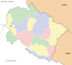
- Dwarahat
-
Dwarahat — town — Coordinates 29°47′N 79°26′E / 29.78°N 79.43°ECoordinates: 29°47′N 79°26′E / 29.78°N 79.43°E Country India State Uttarakhand District(s) Almora Population 2,543 (2001[update]) Time zone IST (UTC+05:30) Area
• 1,467 metres (4,813 ft)
Codes-
• Pincode • 263653
Dwarahat is a town and a nagar panchayat in Almora district in the state of Uttarakhand, India.
Contents
Geography
Dwarahat is located at 29°47′N 79°26′E / 29.78°N 79.43°E.[1] It has an average elevation of 1,510 metres (4954.068 feet).
Demographics
As of 2001[update] India census,[2] Dwarahat had a population of 2543. Males constitute 53% of the population and females 47%. Dwarahat has an average literacy rate of 82%, higher than the national average of 59.5%: male literacy is 86% and, female literacy is 78%. In Dwarahat, 10% of the population is under 6 years of age.
Education
A Govt. Engineering College "Kumaon Engineering College Dwarahat" is located in Dwarahat. A polytechnical college and Degree college and the best school is Sishu mandir dwarahat .
References
- ^ Falling Rain Genomics, Inc - Dwarahat
- ^ "Census of India 2001: Data from the 2001 Census, including cities, villages and towns (Provisional)". Census Commission of India. Archived from the original on 2004-06-16. http://web.archive.org/web/20040616075334/http://www.censusindia.net/results/town.php?stad=A&state5=999. Retrieved 2008-11-01.
External links
- Dwarahat, Official website
- The Paperhut Project - An interesting article on Dwarahat originally published in Outlook India
- Dunagiri For information about Dunagiri and other surrounding areas of Dwarahat
Cities and towns in Almora district Almora Cities and towns
in other districtsBageshwar · Chamoli · Champawat · Dehradun · Haridwar · Nainital · Pauri Garhwal · Pithoragarh · Rudraprayag · Tehri Garhwal · Udham Singh Nagar · Uttarkashi
Categories:- Cities and towns in Almora district
- Almora
- Uttarakhand geography stubs
-
Wikimedia Foundation. 2010.


