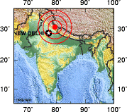
- 1999 Chamoli earthquake
Earthquake
title=1999 Chamoli earthquake
date=29 March 1999 [http://www.iirs-nrsa.gov.in/pdf/brijesh_thesis2005.pdf Earthquake Risk Assessment of Buildings: Applicability of HAZUS in Dehradun, India] "Indian Institute of Remote Sensing "] [http://www.imd.ernet.in/section/seismo/static/chamoli.htm Chamoli earthquake of March 29, 1999] "India Meteorological Department "]
magnitude = 6.8 Mw [http://www.ias.ac.in/currsci/jul10/articles10.htm 29 March 1999 Chamoli earthquake: A preliminary report on earthquake-induced landslides using IRS-1C/1D data] "Indian Academy of Sciences "]
depth=convert|21|km|mi|0
location=coord|30.408|N|79.416|E [http://www.adpc.net/audmp/projectoutputs/nepal/report-chamoli-eq-1.pdf Chamoli Earthquake of 29th March 1999, India] "Asian Disaster Preparedness Center"]
countries affected = IND
casualties = Approximately 103 dead.The 1999 Chamoli earthquake occurred on
29 March 1999 in theChamoli district in theIndia n state ofUttar Pradesh (now inUttarakhand ). Theearthquake was the strongest to hit the foothills of the Himalayas in more than ninety years. [http://news.bbc.co.uk/2/hi/south_asia/306721.stm World: South Asia Quake death toll nears 100] "BBC News "] Approximately 103 people died in the earthquake.Cause
The Himalaya Range has been undergoing crustal shortening along the 2,400 km long northern edge of the
Indian Plate which resulted in the formation of severalthrust plane s including the Main Central Thrust (MCT), the Main Boundary Thrust (MBT) and the Main Frontal Thrust (MFT). The MCT consists of three sub-thrusts: MCT I, MCT II and MCT III. Many earthquakes have occurred along these thrust faults. Academics believe the Chamoli earthquake in 1999 is associated with these fault systems. [http://www.nicee.org/eqe-iitk/uploads/EQR_Chamoli.pdf Chamoli (Himalaya, India) Earthquake of 29 March 1999] "National Information Center of Earthquake Engineering"]Description
The magnitude of the earthquake was 6.8 on the
Richter scale , [http://news.bbc.co.uk/2/hi/south_asia/306597.stm World: South Asia Earthquake hits India] "BBC News"] and it lasted for forty seconds. Apart from the Chamoli district, the quake also affected five other districts of Uttar Pradesh viz.Rudraprayag ,Tehri Garhwal ,Bageshwar ,Uttarkashi andPauri Garhwal (all are inUttarakhand now). Among these, Chamoli and Rudraprayag were the most affected districts.Aftershock s continued and most of the aftershocks occurred in the east of Chamoli. Officials from Pakistan reported that the quake was also felt inLahore andGujranwala . The earthquake was also felt in theNanda Devi mountain region, inKanpur ,Shimla ,Delhi ,Dehradun ,Haridwar ,Saharanpur ,Moradabad ,Bijnor ,Muzaffarnagar ,Meerut ,Ghaziabad andSrinagar and in theBaitadi District ,Dadeldhura District ,Darchula District andKanchanpur District inMahakali Zone inNepal .Damage and casualties
Severe ground deformations resulted from the earthquake. Formation of ground fissures were reported from many areas.
Landslide s and changes in thegroundwater flow were also reported. Well-developed ground cracks were seen inGopeshwar , Chamoli and Bairagna. Cracks were observed in asphalt roads at several locations. Landslips cut off parts of Mandakini valley and Mandal valley and many major roads.The death toll was 103. Several hundred people injured and approximately 50,000 houses were damaged. [http://www.ias.ac.in/jess/jun2001/1426.pdf Estimation of source parameters of Chamoli Earthquake, India] "Indian Academy of Sciences"] Over 2000 villages were affected by the earthquake.
Electricity ,water supply andcommunication were also severely affected by the earthquake especially in the Chamoli town, Gopeshwar and Okhimath region ofRudraprayag district . According to Mike Wooldridge, correspondent for theBBC News , Chamoli suffered most damage and almost all the houses and shops built on slopes in the lower part of the town were destroyed.The bridge deck of a pedestrian
suspension bridge situated near Bairagna developed lateralbuckling and the cables of the bridge were loosened. Water pipelines in Chamoli and Gopeshwar towns were damaged affecting water supply due to landslides caused by the quake. The concrete-lined canals of the irrigation network in the affected region sustained some cracks.In Delhi, many buildings sustained non-structural damage. [http://www.hinduonnet.com/2001/01/31/stories/14312185.htm Who's afraid of earthquakes really?] "
The Hindu "] According to Dr B.L. Wadhera, who filed a public interest litigation in theDelhi High Court , cracks developed in the Shastri Bhavan in Delhi which houses several Union Ministries. [http://www.hinduonnet.com/2001/01/27/stories/0127000e.htm 'Delhi ill-equipped to handle quakes'] "The Hindu"] Damage occurred in several buildings inDehradun also. A few old buildings of theSurvey of India sustained collapse of gable masonry, and cracks developed along the junctions between the pitched roof and the masonry walls.Relief efforts
Rescue operations were hampered by landslides, loss of electrical power and the loss of communication links with Chamoli. Many road workers became involved to clear landslide debris from a 16 km stretch of road leading to the worst-affected area. Local people carried out search and rescue operations. Rescue efforts were led by the
Indian Army and Paramilitary personnel were also called-in to aid. The army used helicopters to ferry in supplies. Food and other necessary supplies were air-dropped to villages which lacked motorable roads and where roads were damaged due to landslides. Locals organized a committee to make sure that those most affected receive food.ee also
*
Earthquake hazard zoning of India References
Wikimedia Foundation. 2010.
