- Chitrakoot district
-
This article is about the district. For its eponymous headquarters, see Chitrakoot.
Chitrakoot district
चित्रकूट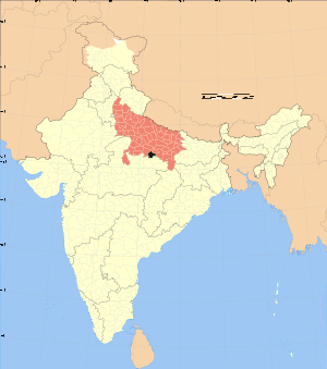
Location of Chitrakoot district in Uttar PradeshState Uttar Pradesh,  India
IndiaAdministrative division Chitrakoot Headquarters Chitrakoot Dham (Karwi) Area .3164 km2 (0.1222 sq mi) Population 801,960 (2001) Official website Chitrakoot district (Hindi: चित्रकूट जिला) is one of the districts of Uttar Pradesh state of India, and Chitrakoot town is the district headquarters. Chitrakoot district is a part of Chitrakoot Division. The district occupies an area of 3,205 km². The district has a population of 766,225 (2001 Census).[1] As of 2011 it is the second least populous district of Uttar Pradesh (out of 71), after Mahoba.[2]
Contents
History
On 6 May 1997 a new district was carved out from the erstwhile Banda district comprising its Karwi and Mau tehsils. The district was initially named as Chhatrapati Shahuji Nagar district. On 4 September 1998 it was renamed as Chitrakoot district.
Economy
In 2006 the Ministry of Panchayati Raj named Chitrakoot one of the country's 250 most backward districts (out of a total of 640).[3] It is one of the 34 districts in Uttar Pradesh currently receiving funds from the Backward Regions Grant Fund Programme (BRGF).[3]
Demographics
According to the 2011 census Chitrakoot district has a population of 990,626,[2] roughly equal to the nation of Fiji[4] or the US state of Montana.[5] This gives it a ranking of 448th in India (out of a total of 640).[2] The district has a population density of 315 inhabitants per square kilometre (820 /sq mi) .[2] Its population growth rate over the decade 2001-2011 was 29.29 %.[2] Chitrakoot has a sex ratio of 879 females for every 1000 males,[2] and a literacy rate of 66.52 %.[2]
Notes
- ^ "Uttar Pradesh". india,gov,in website. http://india.gov.in/knowindia/districts/andhra1.php?stateid=UP. Retrieved 8 May 2010.
- ^ a b c d e f g "District Census 2011". Census2011.co.in. 2011. http://www.census2011.co.in/district.php. Retrieved 2011-09-30.
- ^ a b Ministry of Panchayati Raj (September 8, 2009). "A Note on the Backward Regions Grant Fund Programme". National Institute of Rural Development. http://www.nird.org.in/brgf/doc/brgf_BackgroundNote.pdf. Retrieved September 27, 2011.
- ^ US Directorate of Intelligence. "Country Comparison:Population". https://www.cia.gov/library/publications/the-world-factbook/rankorder/2119rank.html. Retrieved 2011-10-01. "Fiji 883,125 July 2011 est."
- ^ "2010 Resident Population Data". U. S. Census Bureau. http://2010.census.gov/2010census/data/apportionment-pop-text.php. Retrieved 2011-09-30. "Montana 989,415"
External links
- Chitrakoot District on Bundelkhanddarshan.com
- Official website
- Chitrakoot @ Bundelkhand's un-Official web site
- Chitrakoot Information Guide

Fatehpur district Kaushambi district Banda district 
Allahabad district  Chitrakoot district

Satna district, Madhya Pradesh Rewa district, Madhya Pradesh Cities and towns in Chitrakoot district Chitrakoot Cities and towns
in other districtsAgra · Aligarh · Allahabad · Ambedkar Nagar · Auraiya · Azamgarh · Badaun · Bagpat · Bahraich · Ballia · Balrampur · Banda · Barabanki · Bareilly · Basti · Bhimnagar · Bijnor · Bulandshahr · Chandauli · Deoria · Etah · Etawah · Faizabad · Farrukhabad · Fatehpur · Firozabad · Gautam Buddha Nagar · Ghaziabad · Ghazipur · Gonda · Gorakhpur · Hamirpur · Hardoi · Jalaun · Jaunpur · Jhansi · Jyotiba Phule Nagar · Kannauj · Kanpur Nagar · Kanshi Ram Nagar · Kaushambi · Kushinagar · Lakhimpur Kheri · Lalitpur · Lucknow · Mahamaya Nagar · Maharajganj · Mahoba · Mainpuri · Mathura · Mau · Meerut · Mirzapur · Moradabad · Muzaffarnagar · Panchsheel Nagar · Pilibhit · Prabuddhanagar · Pratapgarh · Raebareli · Ramabai Nagar · Rampur · Saharanpur · Sant Kabir Nagar · Sant Ravidas Nagar · Shahjahanpur · Shravasti · Siddharthnagar · Sitapur · Sonbhadra · Sultanpur · Unnao · Varanasi
Divisions and Districts of Uttar Pradesh, India Agra division Aligarh division Aligarh · Etah · Mahamaya Nagar · Kanshi Ram Nagar
Allahabad division Azamgarh division Bareilly division Badaun · Bareilly · Pilibhit · Shahjahanpur
Basti division Chitrakoot division Devipatan division Faizabad division Gorakhpur division Deoria · Gorakhpur · Kushinagar · Maharajganj
Jhansi division Kanpur division Auraiya · Etawah · Farrukhabad · Kannauj · Kanpur Nagar · Ramabai Nagar
Lucknow division Meerut division Bagpat · Bulandshahr · Gautam Buddha Nagar · Ghaziabad · Meerut · Panchsheel Nagar
Mirzapur division Moradabad division Bhimnagar · Bijnor · Jyotiba Phule Nagar · Moradabad · Rampur
Saharanpur division Prabuddhanagar · Muzaffarnagar · Saharanpur
Varanasi division Chitrakoot division topics General Mythology, history Princely States of BundelkhandDistricts Rivers, dams, lakes Languages, people Lok Sabha constituencies See also Cities and towns in Banda district • Cities and towns in Chitrakoot district • Cities and towns in Hamirpur district • Cities and towns in Mahoba district • Villages in Mahoba district • People from Banda • People from Hamirpur • People from MahobaOther Divisions Agra • Aligarh • Allahabad • Azamgarh • Bareilly • Basti • Devipatan • Faizabad • Gorakhpur • Jhansi • Kanpur • Lucknow • Meerut • Mirzapur • Moradabad • Saharanpur • VaranasiCategories:- Districts of Uttar Pradesh
- Chitrakoot district
- Uttar Pradesh geography stubs

Wikimedia Foundation. 2010.