- Mau district
-
This article is about the district. For its eponymous headquarters, see Mau.
Mau district
मऊ ज़िला
ماو ضلع
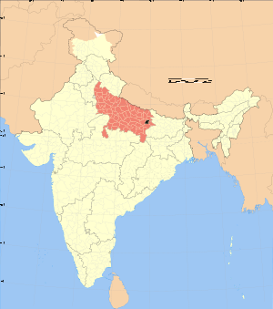
Location of Mau district in Uttar PradeshState Uttar Pradesh,  India
IndiaAdministrative division Azamgarh Headquarters Mau Area 1,713 km2 (661 sq mi) Population 1,849,294 (2001) Literacy 43.8 per cent (1991) Lok Sabha Constituencies Ghosi Official website Mau district (Hindi: मऊ ज़िला, Urdu: ماو ضلع) is one of the districts of Uttar Pradesh state of India and Mau town is the district headquarters. Mau district is a part of Azamgarh Division. Mau district is situated in the south-eastern part of the state with headquarters at Mau town. The district is surrounded by Ghazipur district on the south, Ballia district in the east and Azamgarh district in the west.and north side surrounded by Gorkhpur .Varansi touches some area in south side.The river Ghagra forms its northern boundary and south boundary touch Tamsa river.
Demographics
According to the 2011 census Mau district has a population of 2,205,170,[1] roughly equal to the nation of Latvia[2] or the US state of New Mexico.[3] This gives it a ranking of 206th in India (out of a total of 640).[1] The district has a population density of 1,287 inhabitants per square kilometre (3,330 /sq mi) .[1] Its population growth rate over the decade 2001-2011 was 18.94 %.[1] Mau has a sex ratio of 978 females for every 1000 males,[1] and a literacy rate of 75.16 %.[1]
References
- ^ a b c d e f "District Census 2011". Census2011.co.in. 2011. http://www.census2011.co.in/district.php. Retrieved 2011-09-30.
- ^ US Directorate of Intelligence. "Country Comparison:Population". https://www.cia.gov/library/publications/the-world-factbook/rankorder/2119rank.html. Retrieved 2011-10-01. "Latvia 2,204,708 July 2011 est."
- ^ "2010 Resident Population Data". U. S. Census Bureau. http://2010.census.gov/2010census/data/apportionment-pop-text.php. Retrieved 2011-09-30. "New Mexico - 2,059,179"
External links

Gorakhpur district Deoria district 
Azamgarh district 
Ballia district  Mau district

Ghazipur district Divisions and Districts of Uttar Pradesh, India Agra division Aligarh division Aligarh · Etah · Mahamaya Nagar · Kanshi Ram Nagar
Allahabad division Azamgarh division Bareilly division Badaun · Bareilly · Pilibhit · Shahjahanpur
Basti division Chitrakoot division Banda · Chitrakoot · Hamirpur · Mahoba
Devipatan division Faizabad division Gorakhpur division Deoria · Gorakhpur · Kushinagar · Maharajganj
Jhansi division Kanpur division Auraiya · Etawah · Farrukhabad · Kannauj · Kanpur Nagar · Ramabai Nagar
Lucknow division Meerut division Bagpat · Bulandshahr · Gautam Buddha Nagar · Ghaziabad · Meerut · Panchsheel Nagar
Mirzapur division Moradabad division Bhimnagar · Bijnor · Jyotiba Phule Nagar · Moradabad · Rampur
Saharanpur division Prabuddhanagar · Muzaffarnagar · Saharanpur
Varanasi division Azamgarh division topics General Districts Rivers, dams, lakes Languages, people - Bhojpuri
- Hindi
- Hindi-Urdu
- Standard Hindi
- Urdu
Transport Lok Sabha constituencies See also - Cities and towns in Azamgarh district
- Cities and towns in Ballia district
- Cities and towns in Mau district
- Villages in Azamgarh district
- Villages in Ballia district
- Villages in Mau district
- People from Azamgarh
- People from Ballia
- People from Mau
Other Divisions - Agra
- Aligarh
- Allahabad
- Bareilly
- Basti
- Chitrakoot
- Devipatan
- Faizabad
- Gorakhpur
- Jhansi
- Kanpur
- Lucknow
- Meerut
- Mirzapur
- Moradabad
- Saharanpur
- Varanasi
Categories:- Districts of Uttar Pradesh
- Mau district
- Uttar Pradesh geography stubs
Wikimedia Foundation. 2010.

