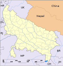
Muhammadabad

Muhammadabad
See also Mohammadabad.
Muhammadabad
—  city  —
Muhammadabad
Location of Muhammadabad
in Uttar Pradesh and India
Coordinates 25°38′N 83°45′E / 25.63°N 83.75°E / 25.63; 83.75Coordinates: 25°38′N 83°45′E / 25.63°N 83.75°E / 25.63; 83.75
Country India
State Uttar Pradesh
District(s) Mau
Population 21,385 (2001)
Time zone IST (UTC+05:30)
Area

Elevation


61 metres (200 ft)

Muhammadabad Gohna is a town and a nagar panchayat in Mau district in the Indian state of Uttar Pradesh. The town has services such as schools, colleges, hospitals, banks, ATMs and many Hi-Tech facilities. The majority of the population are adherents of Islam. Textile and handloom is a flourishing industry in Muhammadabad. This town is also famous for its Imirti Sweets, a kind of sweet made from wheat flour resembling the Indian Jalebi

Geography

Muhammadabad is located at 25°38′N 83°45′E / 25.63°N 83.75°E / 25.63; 83.75 alongside of famous historical Tamsa river, also locally known as the tons river[1] It has an average elevation of 61 metres (200 feet). yaha ke Hindu aur Muslim ekta ke pratik hai

Demographics

As of 2001 India census,[2] Muhammadabad had a population of 21,385. Males constitute 59% of the population and females 41%. Muhammadabad has an average literacy rate of 61%, higher than the national average of 59.5%: male literacy is 67%, and female literacy is 53%. In Muhammadabad, 49% of the population is under 6 years of age.

References


Wikimedia Foundation. 2010.

Игры ⚽ Нужна курсовая?

Look at other dictionaries:

  • Muhammadabad — 1 Original name in latin Muhammadbd Name in other language State code IN Continent/City Asia/Kolkata longitude 27.30854 latitude 79.43368 altitude 154 Population 22151 Date 2012 10 06 2 Original name in latin Muhammadbd Name in other language… …   Cities with a population over 1000 database

  • Bahmani Sultanate — Infobox Former Country native name = conventional long name = Bahmani Sultanate common name = Bahmani Sultanate continent = Asia region = country = era = Late Medieval status = event start = year start = 1347 date start = 3 August event1 = date… …   Wikipedia

  • List of the localities around Tehran — Map = A = *Aba Barik *Ab Ali *Pist e Eski ye Abali *Ab Anjirak *Abar Dezh *Abasabad *Ab Barik *Ferheng *Abbasabad *Abbasabad e Alaqeh Band *Abbasabad e Bozorg *Abbasabad e Dara i *Abbasabad e Ferdows *Abbasabad e Jajrud *Abbasabad e Jalrud… …   Wikipedia

  • Bahmanî — Sultanat de Bahmanî बहमनी सल्तनत (hi) 1347 – 1518/1527 Le sultanat de Bahmanî vers 1470 …   Wikipédia en Français

  • Main Noor Mohammad Kalhoro — This article is about the Sindhi shah. For the 20th century king of Sindh, see Kalhora. Miyan Nur Muhammad Kalhoro Amir of Sindh Reign 1736–1747 Born August 6, 1698 Died June 19, 1747 …   Wikipedia

  • Muhammad Muradyab Khan (Nawab Sarbuland Khan) — This article is about the Sindhi shah. For the 20th century king of Sindh, see Kalhora. Muhammad Muradyab Khan Kalhoro (Nawab Sarbuland Khan) (urdu)محمدمرياب خان كلهورو المعروف نواب سربلندخان: Contents 1 Different agents appointed by the king’s… …   Wikipedia

  • List of India-related articles — Articles (arranged alphabetically) related to India or Indian culture include: NOTOC List of India related topics People are listed by their first names. 1231 SGM 3 STR 2002 Gujarat violence 2005 in India ( previous years ) 2004 Indian Ocean… …   Wikipedia

  • Awadh — Oudh redirects here. For the Oudh tree, see agarwood. For the Arabic musical instrument, see Oud. Historical region of North India Awadh Location …   Wikipedia

  • Faisalabad — فیصل آباد   City District   …   Wikipedia

  • Gilgit — (Urdu: گلگت) is the capital city of the Northern Areas, Pakistan and a tehsil (headquarters) of Gilgit District. Its ancient name was Sargin which later on came to be known as Gilit and it is still called Gilit or Sargin Gilit by local people, in …   Wikipedia

Share the article and excerpts

Direct link
Do a right-click on the link above
and select “Copy Link”