- Ghaghara River
-
Not to be confused with Ghaggar River.
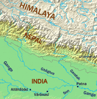
Ghaghara River Karnali River Countries Tibet (China), Nepal, India Tributaries - left Bheri, Sarju, Kuwana, Rapti, Little Gandak - right Seti, Dahawar, Sarda Source Mapchachungo Glacier - location Tibet, China - elevation 3,962 m (12,999 ft) Mouth Ganges - location Doriganj, India - coordinates 25°45′11″N 84°39′59″E / 25.75306°N 84.66639°E Length 1,080 km (671 mi) Basin 127,950 km2 (49,402 sq mi) Discharge - average 2,990 m3/s (105,591 cu ft/s) 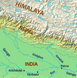 Map showing the Ghaghara and Gandaki tributaries of the Ganges.
Karnali or Ghaghara is a perennial trans-boundary river originating on the Tibetan Plateau near Lake Mansarovar. It cuts through the Himalayas in Nepal and joins the Sarda River at Brahmaghat in India. Together they form the Ghaghra River, a major left bank tributary of the Ganges. With a length of 507 kilometres (315 mi) it is the largest river in Nepal and one of the largest tributary of the Ganges.[1] The total length of Ghaghara River up to its confluence with the Ganges at Doriganj in Bihar is 1,080 kilometres (670 mi).[2]
In Chinese it is called K'ung-ch'iao Ho, in Nepali it is called Kauriala and Karnali. It is also spelled Gogra, Ghaghra, Ghagra, or Ghāghara.[3]
Contents
River course
 Source of Karnali River
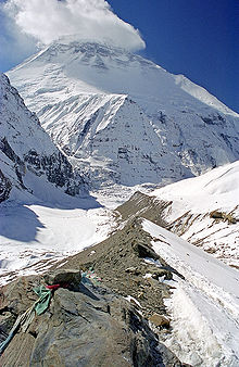
It rises in the southern slopes of the Himalayas in Tibet, in the glaciers of Mapchachungo, at an altitude of about 3962 metres (13,000 ft) above sea level. The river flows south through one of the most remote and least explored areas of Nepal as the Karnali River. The 202 km Seti River drains the western part of the catchment and joins the Karnali River in Doti District north of Dundras hill. Another tributary the 264 km long Bheri rises in the western part of Dhaulagiri Himalaya and drains the eastern part of the catchment, meeting the Karnali near Kuineghat in Surkhet.[4]
Cutting southward across the Siwalik Hills, it splits into two branches, the Geruwa on the left and Kauriala on the right near Chisapani to rejoin south of the Indian border and form the proper Ghaghara. Other tributaries originating in Nepal are the West Rapti, the Kali or Mahakali and the little Gandak. Another important tributary of Ghaghara in India is the Sarayu river, famous for the location of Ayodhya, the capital of Dasarath’s Kingdom. It flows southeast through Uttar Pradesh and Bihar states to join the Ganges downstream of the town of Chhapra, after a course of 1080 km. It carries more water than the Ganges before its confluence. Sarayu river is stated to be synonymous with the modern Ghaghara river or as a tributary of it.
Karnali River exposes the oldest part of the Sivalik Hills of Nepal. The remnant magnetization of siltstones and sandstones in this group suggests a depositional age of 16-5.2 million years.[5]
Karnali River Basin
The Karnali River Basin lies between the mountain ranges of Dhaulagiri in Nepal and Nanda Devi in Uttarakhand. In the north, it lies in the rain shadow of the Himalayas. The basin formed by the river has a total catchment area of 127,950 km2, of which 45% is in India. The population of the Basin districts in Nepal increased from 1.9 million in 1971 to 4.7 million people in 2001, almost a 250% increase over three decades. The average population density of the Basin area increased from 53 person/km2 in 1981 to 87 persons/km2 in 2001. There is a steady growth in the economically active population in the Basin districts. The average literacy rate has increased from a mere 7.5% in 1971 to 45% in 2001. The social status of the permanent households increased from 24% in 1991 to 31% in 2001. The Basin has a total road length of 2,640 km, but the pace of road development is slow.[6]
Tributaries
Chhoti Gandak is a groundwater-fed meandering river originating near Dhesopool, Maharajganj district of Uttar Pradesh. It travels a distance of about 250 km and joins Ghaghara near Gothani, Siwan district of Bihar. The Chhoti Gandak River Basin is located between 26°00' to 27°20' N latitude and 83°30' to 84°15' E longitude. Right bank tributaries are Khekhra, Hirna, Jethan, Maun, Duhari, Kanchi and Koilar rivers; Khanua river joins from the left bank. The discharge of Chhoti Gandak is mainly controlled by rain, which is very high during the monsoon season and low during the summers. It has been observed that whenever precipitation is high in the catchment areas, there is flood in the downstream part of the Chhoti Gandak River Basin. The region exhibits upland terrace surface, river valley terrace surface, present-day river channel with narrow flood plains, natural levee, and point-bar deposits. All these geomorphic features are depositional in nature and made up of alluvium of different ages.[7][8][9][10]
The main tributaries of the Karnali are: the Seti, the Bheri.[11]
Administrative zones and districts
In Nepal, Karnali Zone is the largest zone with about 5,000 square miles (13,000 km2) area. It is Nepal's most remote region and not yet accessible by road. Its administrative center is Jumla. The zone is divided into the 5 districts of Dolpa, Humla, Jumla, Kalikot and Mugu.[12]
The Karnali zone has the lowest population density in Nepal. There are no large settlements on the banks of the river, which is only crossed near Chisapani by the Mahendra Highway. This major road is now under construction to Jumla.
In India, the administrative districts in the Ghaghra catchment are Ambedkarnagar, Azamgarh, Barabanki, Basti, Ballia, Bahraich, Deoria, Faizabad, Gonda, Gorakhpur, Sant Kabir Nagar, Jaunpur, Kheri, Lakhimpur, Sitapur of Uttar Pradesh and Siwan district in Bihar.
Important towns in India include Akabarpur, Ayodhya Faizabad, Bahraich, Barabanki, Basti, Deoria, Dohrighat, Gonda, Gorakhpur, Khaililabad, Sitapur, Siddharthnagar, Saint Kabir Nagar and Tanda in Uttar Pradesh and Chapra, Deoria, Siwan, Saran and Sonepur in Bihar.
National parks in the Karnali Basin
The Karnali Basin hosts some of Nepal's famous national parks. The protected area constitutes nearly 14% of the total Basin area, including four national parks, one wildlife reserve, one hunting reserve and two buffer zones. The Basin and its influence area constitute 27% of the total protected area, 63% of national park, 25% of the buffer zone and 31% of wildlife reserve. The significance of some of the protected areas is summarised below:
Shey Phoksundo National Park in Dolpa District, established in 1984, is situated in the trans-Himalayan region of northwestern Nepal and represents the Tibetan Plateau ecosystem. The park covering an area of 3,555 km2 contains luxuriant forests mainly composed of blue pine, spruce, cypress, poplar, fir and birch. It is habitat for the endangered snow leopard, the blue sheep and many species of birds such as Himalayan Monal, Blood Pheasant, Cheer Pheasant and Snow Partridge. It is a religious Buddhist site.
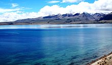
Rara National Park is located in Mugu District with a small area in Jumla District in the mountain region of northwestern Nepal and is the smallest park with a size of 106 km2. It includes Rara Lake, the biggest lake in Nepal of 10.8 km2 in size at an altitude of 2990 m. The lake is oval shaped and has a maximum length of 5 km and a width of 3 km. The vegetation of the park consists of coniferous trees such Blue Pine, Rhododendrons, Black Juniper, West Himalayan Spruce, Oak and Himalayan Cypress. The fauna includes Musk deer, Himalayan Black Bear, Leopard, Goral, Jackal, Himalayan Tahr, Yellow-throated Marten, Dhole, Wild Boar, Gray langur, Rhesus Macaque and Otter. Common bird species include migrant waterfowl, coot, Great-crested and Black-necked grebes, Red-crested Pochard, Mallard, Common Teal, Common Merganser, Himalayan Snowcock and Chukar Partridge.
Bardia National Park is the largest and most undisturbed protected area in the Terai region of the Nepal Himalayas, covering 968 square kilometres (374 sq mi) on the southern slopes of the Sivalik Hills. It is bordered in the south by the Babai River, and to the west by the Girwa River, a tributary of the Karnali. At Chisapani Gorge, the swift-flowing Karnali River emerges from the Shiwalik Range onto the broad plain and flows purposefully through the semi-tropical jungle. The park is famous for two herds of wild Asian elephants, a great number of deer species, Gaur, Nilgai, Himalayan Tahr, Serow and Goral. The Karnali supports the endangered Mugger crocodile, the fish-eating Gharial, a few remaining specimen of Gangetic Dolphin and the Golden Mahseer; latter weigh up to 90 lb (41 kg).
Endangered Species
The Karnali provides the upper range for the Gangetic river dolphin (Platanista gangetica), the largest freshwater mammals found on the Indian subcontinent. They are considered vulnerable species under CITES Appendix 1 and are classified as endangered on the IUCNRedlist (IUCN, 2004). The river dolphins are legally protected animals in Nepal as endangered mammal and fall under Schedule I of the protected list of National Parks and Wildlife Conservation Act, 1973. Living at the upstream range limit, dolphins in the Karnali River are particularly vulnerable to threats from habitat degradation. Dolphins need deep pools of water. They are often found in places where human activities are most intense and they are sometimes accidentally caught by the local people who live in the lower Karnali basin. The Karnali River supports the last potentially viable population of the Ganges River dolphin in Nepal. These dolphins are at their farthest upstream range and isolated by the Girijapur Barrage (a low gated dam), located about 16 km downstream of the Nepal/India border.[13]
A high dam has been planned for some time just upstream of the dolphins' current (or at least recent) range in the Karnali River, Nepal. If built, this structure would almost certainly eliminate the small amount of dolphin habitat in Nepal’s last river with a potentially viable dolphin population. Disturbance and environmental degradation associated with geotechnical feasibility studies and bridge and road construction for the dam already may have contributed to a decline in the number and range of dolphins orsusuabove the Nepal-India border.[14] The Ghaghara is the furthest upstream in the dolphin range.
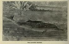 Gangetic Dolphin
Other important protected areas and their biological and religious significance are a) Khaptad NP (2.25 km²), 1984 - Oak, Fir, Conifer, Musk deer, Leopard, Black Bear. Ashram of late Khaptad Baba (sage), Shiva shrine, Khaptad daha - a shallow lake; b) Dhorpatan HR (13.25 km²), 1987- Fir, Hemlock, Spruce, Birch, Junipers, grassland. Game hunting reserve; and c) Royal Suklaphanta - WR (1976) at Kanchanpur (3.05 km²) in the Terai Sal, Acacia, Sisso, extensive grassland, Elephant, Swamp deer, Tiger, Hispid hare, Bengal florican.[15]
Development projects on the river
In Nepal
The Karnali basin is the first to arouse keen interest in Nepal's vast hydropower development study. There are several attractive sites for the generation of cheap hydroelectric energy in this basin.[16]
The Master Plan Study for Water Resource Development of the Upper Karnali River and Mahakali River Basins (1993) identified 32 potential hydropower projects in the Karnali Basin. Despite the high potential of hydropower development (32,000 MW) in the Basin, only 2,245 kW capacities (from eight micro hydel schemes) has been developed so far.
Considering the pace of hydropower development in Nepal (Out of 83,000 MW potential, only 314.6 MW capacity hydropower projects were targeted for completion by 2007) in general and in the Karnali Basin in particular, harnessing the total hydropower potential of the Basin is envisaged to take a long time. Based on recent water resources development planning and project progress, the likely large scale hydropower projects that will be operational in the Basin by 2025 are predicted to be: West Seti HEP (750 MW); Upper Karnali HEP (300 MW); Bheri-Babai Multipurpose Project (48 MW); and Lohore Khola HEP (58 MW).[17]
West Seti HEP (750 MW)
The proposed West Seti HEP is located on the Seti River in the Far-Western Development Region of Nepal. The West Seti HEP catchment covers the upper 4,022 km² of the Seti River Basin. The West Seti HEP is a large storage project with a rated capacity of 750 MW. The power station is located approximately 63 km upstream of the Seti River confluence with the Karnali River, with the dam site located a further 19.2 km upstream. All project sites, excluding the reservoir area and transmission line corridor, are located in either Doti and/or Dadeldhura Districts. The reservoir area is located in Doti, Dadeldhura, Baitadi and Bajhang Districts. The transmission line corridor is located in Doti, Dadeldhura, Kailali and Kanchanpur Districts. The project has been allocated for development as BOOT project under private sector.
Upper Karnali HEP (300 MW)
The proposed Upper Karnali HEP is located on the main course of the Karnali River and has a catchment area of 20,120 km². This project is one of Nepal's most economically attractive runof- river diversion schemes (300 MW), with daily peaking capacity and high firm energy. Project facilities will be located in three districts: Surkhet, Dailekh and Achham. Project hydrology is based on data from station 240 at Asaraghat. The river is snow fed and the mean annual estimated flow at the headworks is 500 m³/s. The project has been allocated to GMR of India for development on BOOT basis.
Bheri-Babai Multipurpose Project (48 MW)
The Bheri-Babai Multipurpose Project is an inter-Basin water transfer project prioritised for the development of irrigation in Bardia District . The intake of the Bheri-Babai (BR-1) diversion scheme lies on the Bheri River 45 km upstream of the confluence with the Karnali River. The tailrace outlet is located in the Babai River 20 km upstream of the existing Babai irrigation project diversion weir. The Bheri-Babai project aims to generate electricity and supply additional water to the Babai Irrigation Scheme in the Terai by diverting 40 m3/s of water from the Bheri River into the Babai River. project is yet to undergo a feasibility study.
Lohore Khola HEP (LR-1) – (58 MW)
The Lohore Khola HEP is a proposed reservoir storage project situated on the Lohore Khola, a tributary of the Karnali River in Dailekh District. The project is located a few kilometers downstream from the confluence with Chham River and upstream of Dungeshowr. The catchment area of the Lohore River at the reservoir site is 733 km². Based on the isohyetal map of the Karnali River Basin, average annual rainfall for the Basin is estimated to be 1,539 mm. As there is no stream gauge on the Lohore River, its flow was estimated using data from Station 240 (1963–2000) located on the Karnali River at Asaraghat with a catchment area of 19,260 km2. The sediment flow into the river is estimated to be 2.4 million tonnes per year. As the economic internal rate of return (EIRR) for the project is highest for the draft rate of 0.7, the flow for power generation was estimated for this draft rate. The riparian flow was assumed to be 10% of the monthly minimum flow (i.e. 0.53 m3/s).
Karnali (Chisapani) Multipurpose Project (10,800 MW)
The site of the Karnali Multipurpose Project, also Chisapani Dam Project, is located in the Karnali Gorge, immediately upstream of the Terai. The project has a catchment area of 43,679 km², covering nearly 30% of Nepal. The long-term average river flow is 1,389 m3/s, with an average dry season flow (November–May) of 451 m3/s and an average wet season flow (June–October) of 2,690 m3/s. The Karnali (Chisapani) Multipurpose Project is a potential mega multipurpose storage project on the Karnali River at Chisapani, envisaging a 270 m high dam, with reservoir area of 350 km², with power station operating under a design head of 185 m to operate 18 units of 620 MW capacity each ( 10,800 MW installed capacity) and with a reregulating wier downstream with power plant of 84 MW capacity operating under a head of 13.5 m. A Large scale irrigation development is also envisaged - 2,380 km² in Nepal and 32,000 km² India. Project planning commenced in 1960, although the feasibility study for the project was only completed in 1989. Before this project is developed a number of significant underlying issues have to be resolved. These issues include: Nepal and India reaching a bilateral agreement on the downstream benefits of regulated river flows; the resettlement of over 60,000 people; the impact on and restoration of habitat within Bardia National Park; and, above all, the financial arrangements for project funding. Accordingly, it is predicted that the chances of this project being implemented before 2025 are very slim, although increasing international pressure on reducing greenhouse gas (GHG) emissions from the energy generation sector may assist project initiation. While the likelihood of this project being developed by 2025 is low, Nepal and India could cooperate to develop this project to meet India’s growing energy demand from renewable resources.
Irrigation
Irrigation in Nepal
The major existing river use by volume in the Karnali Basin is irrigation. Three areas on the Nepal Terai and two areas in India are irrigated from the Karnali River. Within Nepal, two areas are irrigated in Bardia District (23.2 and 183.4 km²) and a single site is irrigated in Kailali District (139.25 km²). The total demand for irrigation water from the Karnali River by these three areas represents a very small proportion of existing total annual river flows, amounting to a mean annual rate of 54 m3/s. This is equivalent to 3.9% of the 1,370 m3/s mean annual Karnali River flow into India.[18]
Irrigation in India
In India, water is diverted from the Karnali River at the Girijapur Barrage into the Sarda Sahayak Irrigation Scheme and the Saryu Nahar Irrigation Scheme, which have command areas of 20,000 km² and 12,000 km² respectively. The combined annual irrigation demand of these two schemes is approximately 10,000 million m3.[18]
The Sarda Sahayak Irrigation Project utilizes the combined flows from the rivers Ghaghara and Sarda in the Girija Barrage built across the Ghaghara river (catchment area - 45,500 km2). This barrage is situated about 9 km downstream of Khatria Ghat Rly station and 16 km from the international border to Nepal in Bahraich district. It is linked to the Lower Sarda Barrage built across the Sarda river (catchment area 17,818 km2), about 28 km North East of Lakhimpur Kheri Rly station in Lakhimpur Kheri district. The link canal from Girija Barrage to the Sarda Barrage is 28 km long and designed to divert a discharge of 480 m³/s from Gandak to Sarda river. The feeder channel taking off from the Lower Sarda Barrage is 258.8 km long, feeds the five branches of Dariyabad, Barabani, Haideganj, Raei Bareil and Purva, and is designed to carry a discharge of 765 m³/s. The Sarda Sahayak feeder channel meets the Haidergarh branch at 171 km and Raibareli branch at 187 km. The entire canal system is considered the largest in Asia and designed to provide irrigation to a Culturalable Command Area (CCA) of 20,000 km2 covering 14 districts in 168 blocks with a gross command area of 40,000 km2.
On account of high silt flows during the flood season, Sarda Sahayak supplies (from Karnali) are suspended for 100 days between June and October, when the Lower Sarda Canal (feeder canal) draws water from the Sarda River, which is then flooded.[19]
In the past the Karnali River was considered to be attractive for the development of navigation right from the Indo-Nepal border till the confluence of this river and the Ganges. The lower reach of this river – called the Ghaghra in India was used in the past for navigation by steamers. Apart from in the foothills of the Himalayas where most of the streams were simply fast-moving water throughout the greater part of the year and not navigable when flowing rapidly, most of the rivers with steadier currents had boats on them. The Ganges, the Ghaghra, the Yamuna, the Gomti, the Sharda and the Rapti were the most important navigable rivers in the Northwestern provinces and Oudh.
Many trade items such as timber, food grains, sugar, indigo, cotton seed, poppy seed and mustard seed were transported by boats. April, May and June were the most suitable months and were a busy trading period. Different kinds of cargo boats were used on the Ganges, the smaller ones were known as palwars, while the larger ones were known as katris.
In the latter half of the 19th century when the railways came into existence, the significance of waterways as inland trade routes declined, as the railways were faster and safer. With the exception of eastern parts of Bengal where abundance of water in the natural network of channels sustained and continued to provide a suitable mode of transport of goods and people, the railways had almost entirely replaced the waterways as communication lines throughout the country by the end of the 19th century.[20]
The possibilities for further extension of the steamer services to the north had also been explored in the past. The Central Water and Power Commission of the Govt. of India had carried out hydrographical survey of the Karnali River from the Bahramghat to the confluence of this river and the Ganges a distance of 446 km. This survey was done in the years 1943-53 to explore the possibility of improvement and extension of navigation on this river by powered crafts. These surveys revealed that there were only 5 shoals under 90 cm at low water between Burhaj and Bahramghat a distance of about 300 km. The minimum depth was 75 cm. These depths were available without any river conservancy works. All other conditions of navigable channel such as the width and current of flow etc. were also found to be very favourable. The low water stage in this river is only for a short duration. There is a great urgency to carry out detailed study of the Karnali river to develop modern inland waterway by applying various channel improvement technologies.[21]
See also
References
- ^ Jain, Sharad K.; Agarwal, Pushpendra K.; Singh, Vijay P. (2007). Hydrology and water resources of India. Springer. p. 341. ISBN 9781402051791. http://books.google.com/books?id=ZKs1gBhJSWIC&pg=PA341. Retrieved 26 April 2011.
- ^ Jain, S.K., Agarwal, P.K., Singh, V.P. (2007) Hydrology and Water Resources of India Springer, The Netherlands. ISBN 1-4020-5179-4. book preview
- ^ Ghāghara River - Britannica Online Encyclopedia
- ^ Karnali River: Longest River of Nepal « Wildlife in West Nepal
- ^ Gautam, P., Fujiwara, Y. (2000) Magnetic polarity stratigraphy of Siwalik Group sediments of Karnali River section in western Nepal. Geophysical Journal International, Volume 142, Issue 3: 812-824. download pdf
- ^ West Seti Hydroelectric Project (2007) Karnali Basin Cumulative Impact Assessment. Report by West Seti Hydro Limited, Kathmandu, Nepal download pdf
- ^ Bhardwaj, V., Singh, D.S., Singh, A.K. (2010) Hydrogeochemistry of Ground water and anthopogenic control over dolomatization reaction in alluvial sediments of the Deoria district: Ganga Plain India. Environmental Earth Sciences 59:1099-1109. Abstract
- ^ Bhardwaj, V., Singh, D.S., Singh, A.K. (2010) Water Quality of the Chhoti Gandak River using Principal Component Analysis, Ganga Plain, India. Journal of Earth System Sciences, 119 (1) pp 1-12. download pdf
- ^ Bhardwaj, V., Singh, D.S., Singh, A.K. (2009) Environmental repercussions of cane-sugar industries on the Chhoti Gandak river basin, Ganga Plain, India. Environmental Monitoring and Assessment. (DOI 10.1007/s10661-009-1281-2). Abstract
- ^ Singh, D.S., Awasthi, A., Bhardwaj, V. (2009) Control of Tectonics and Climate on Chhoti Gandak River Basin, East Ganga Plain, India. Himalayan Geology, Vol 30 (2) 2009, pp 147-154.
- ^ Negi, Sharad Singh. Himalayan rivers, lakes and glaciers. http://books.google.co.in/books?id=5YtUShKY8zcC&pg=PA84&lpg=PA84&dq=Panjang+River&source=bl&ots=_HeiS4rvh6&sig=HLDo37YW3yRs19ACPEyHvhuWqBc&hl=en&ei=GhkBTPfOLZTDrAeRzdE8&sa=X&oi=book_result&ct=result&resnum=8&ved=0CDsQ6AEwBw#v=onepage&q=Panjang%20River&f=false. Retrieved 2010-05-29.
- ^ The Karnali Zone of Nepal
- ^ untitled
- ^ 2007 IUCN Red List – Search
- ^ I
- ^ Opinion (Spotlight Weekly)
- ^ http://wsh.com.np/.../Cumulative_Impact_Assessment(CIA)_final_23Nov_07.pdf
- ^ a b EIA - VOL 1b.pdf
- ^ Parajuli, U. (2003) Water sharing Conflicts between Countries, and Approaches to resolving them. WASSA Project Reports, Volume 3 download pdf
- ^ Sea and Inland Navigation
- ^ Wafed - Nepal
External links
Hydrology of South Asia Inland Indus · Ganges · Yamuna · Chenab · Jhelum · Bhagirathi River · Brahmaputra · Godavari · Narmada · Tapti · Ravi · Beas · Sutlej · Padma · Sarasvati · Sharda · Krishna · Kaveri · Kali River · Meghna · Gandaki River · Mahanadi · Mahaweli · Son · Ghaghara · Betwa · Chambal · Kosi · Sankosh · Ganges Basin · Ganges Delta · Indus Delta · Dal Lake · Pookode Lake · Skeleton Lake · Chilka Lake · Lake Powai · Borith Lake · Saiful Muluk · Gosaikunda · Nizam Sagar · Red Hills Lake · Malampuzha · Kerala Backwaters · Damodar · LuniCoastal Categories Lakes of India / Nepal / Pakistan · Reservoirs and dams in India · Rivers of Bangladesh / Bhutan / India / Nepal / PakistanHydrology of Nepal Rivers Mahananda basinSapta Koshi basinArun or Bum-chu • Barun • Bhote Koshi or Rongshar Tsangpo • Dudh Kosi • Hongu • Imja Khola • Indravati • Kosi or Sapta Koshi • Sabha • Sangkhuwa • Siswa • Sun Kosi or Matsang Tsangpo • TamurBagmati basinBagmati • Bisnumati • Kamala • LakhandeiNarayani basinKarnali basinBheri • Karnali or Ghagra • Kalapani • Kali • Panjang • Rohini • Sarda or Mahakali • Seti • Thuli Bheri • West Rapti RiverLakes Glaciers Icefalls Related topics Hydrology of Uttar Pradesh Rivers Main riversNorth flowingSouth flowingLakes Dams/ Barrages Canals Bridges Malviya Bridge • Shahi Bridge, JaunpurRelated topics Hydrology of
surrounding areasUttarakhand • Nepal • Bihar • Jharkhand • Madhya PradeshCategories:- Rivers of Nepal
- International rivers of Asia
- Tributaries of the Ganges
- Rivers of Uttar Pradesh
- Rivers of Tibet


Wikimedia Foundation. 2010.