- Dolpa District
-
Dolpa
डोल्पा— District — Phoksundo Lake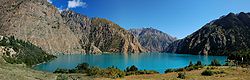 Location of Dolpa
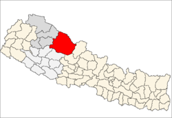
Country  Nepal
NepalRegion Mid-Western (Madhya Pashchimanchal) Zone Karnali Area – Total 7,889 km2 (3,046 sq mi) Population (2001) – Total 29,545 – Density 3.7/km2 (9.7/sq mi) Time zone NPT (UTC+5:45) Main language(s) Nepali Dolpa District(Nepali: डोल्पा जिल्ला
 Listen (help·info), is one of the five districts of the Karnali Zone in Nepal - a landlocked country of South Asia. The district, with Dunai as its district headquarters, covers an area of 7,889 km2 (3,046 sq mi) and has a population (2001) of 29,545.
Contents
Geography
Dolpa is the largest district of Nepal covering 5.36% of the total landmass of the country. Located between 28°24’ N - 29°43’ N latitude, and 82°24’ E - 83°38’ E longitude, the elevation in Dolpa ranges from 1,525 to 7,625 m (5,003 to 25,016 ft) above sea level. The district borders Tibet ( China) on the north and northeast, Jumla and Mugu districts of Karnali on the west, Myagdi, Jajarkot and Rukum on the south and Mustang on the east.
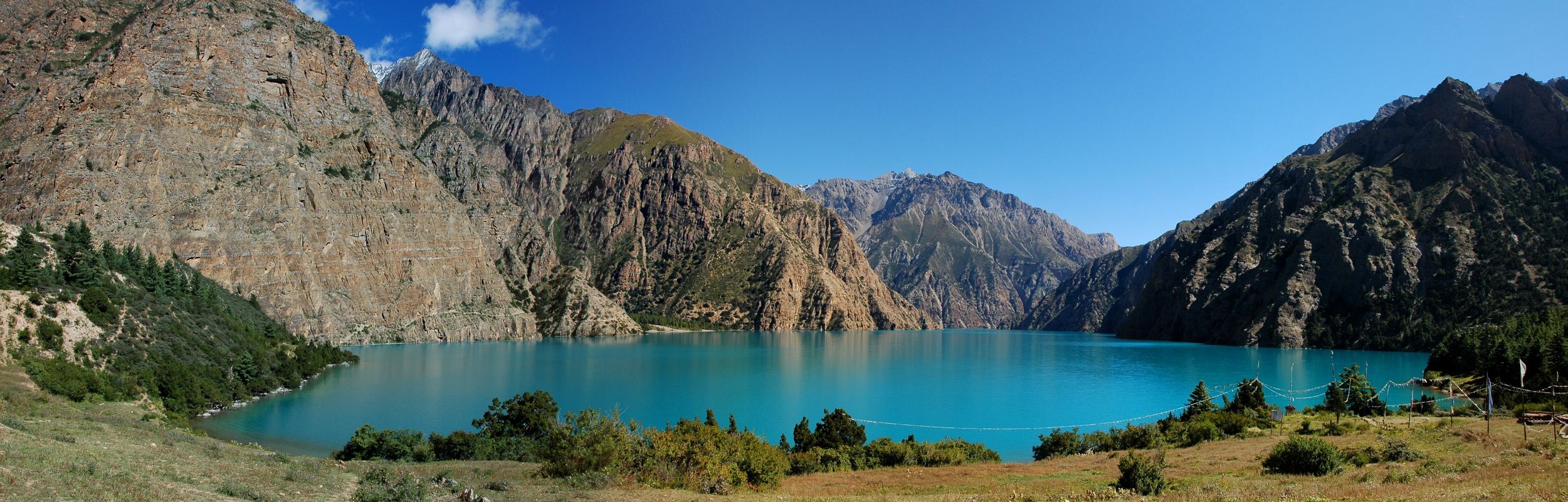
A large portion of the district is protected by Shey Phoksundo National Park. The name is derived from the 12th century Shey Monastery and the deepest lake in Nepal, the Phoksundo Lake, both of which lie in the district. The park protects endangered animals like the snow leopard, musk deer and the Tibetan wolf. Shey Phoksundo is the largest and the only trans-Himalayan National Park in Nepal.
It is also one of the two districts that lie beyond the Himalaya or the trans-Himalaya, Mustang being the other.
The district distances an altitudinal range of over 5,000 m (16,000 ft) from a little over 1,500 m (4,900 ft) at Tribeni in Kalika VDC to 7,381 m (24,216 ft) meters at the peak of Churen Himal. Kanjiroba (6,221 m (20,410 ft)), Mukot (6,638 m (21,778 ft)) and Putha Hiunchuli (7,246 m (23,773 ft)) are other renowned peaks.
Physiographical the smaller ranges of the Great Himalayas comprise the southern border of the district. Between these and the border mountain ranges of Gautam Himal and Kanti Himal to the north, Dolpa district is a labyrinth of often wide glacial valleys and ridges. Kanjiroba Himal and Kagmara Lekh running northwest to southeast separate the valleys of the Jagdula in the west from the rest of the district.
Demography
Dolpa's population is approximately 29,545. Most of the people are Hindu (60%) or Buddhist (40%). 5.05% belong to the ancient Bonpo religion. Dolpa's major occupations are agriculture (79.5%) and service (2%).
Tourism
Dolpa region is a distant region of Nepal and the central point of this area is Shey Phoksumdo National Park. The east and south of Dolpa are surrounded by the Dhaulagiri and Churen Himal ranges and to the west is the Jumla district. Trekking to Lower Dolpa offers you the remarkable and breathtaking experience of a lifetime. The notable features seen here are snowy peaks, ancient and remote villages, rich wildlife, lovely Buddhist monasteries and wonderful lakes. The people of this area are simple and warm-hearted with an enthralling culture and traditions. The cultural traditions of this area are basically linked with the Tibetan culture.
Trekking into Dolpa presents an exposure to the high and remote Himalayan valleys, resembling the Tibetan highlands. The main highlight of Dolpa trekking includes “Shey Phoksundo National Park” which is one of the major National Parks of Nepal. “Shey Phoksundo Lake” is another famous feature of this region. The lake is totally free of aquatic life, which the crystal waters clearly demonstrate. Surrounded by rocks, forests, and snow-capped peaks, the area has been described as one of the world's “Natural Hidden Wonders”.
The Dolpa trekking starts at Juphal and follows the track to Dunai, then continues to Tarakot, way up to Bang la Camp, the uppermost point of Dolpa trekking. After passing through Sanu Bheri village, we then descend to the good-looking Phoksundo Lake, which is a piece of the Shey Phoksundo National Park.
Towns and villages
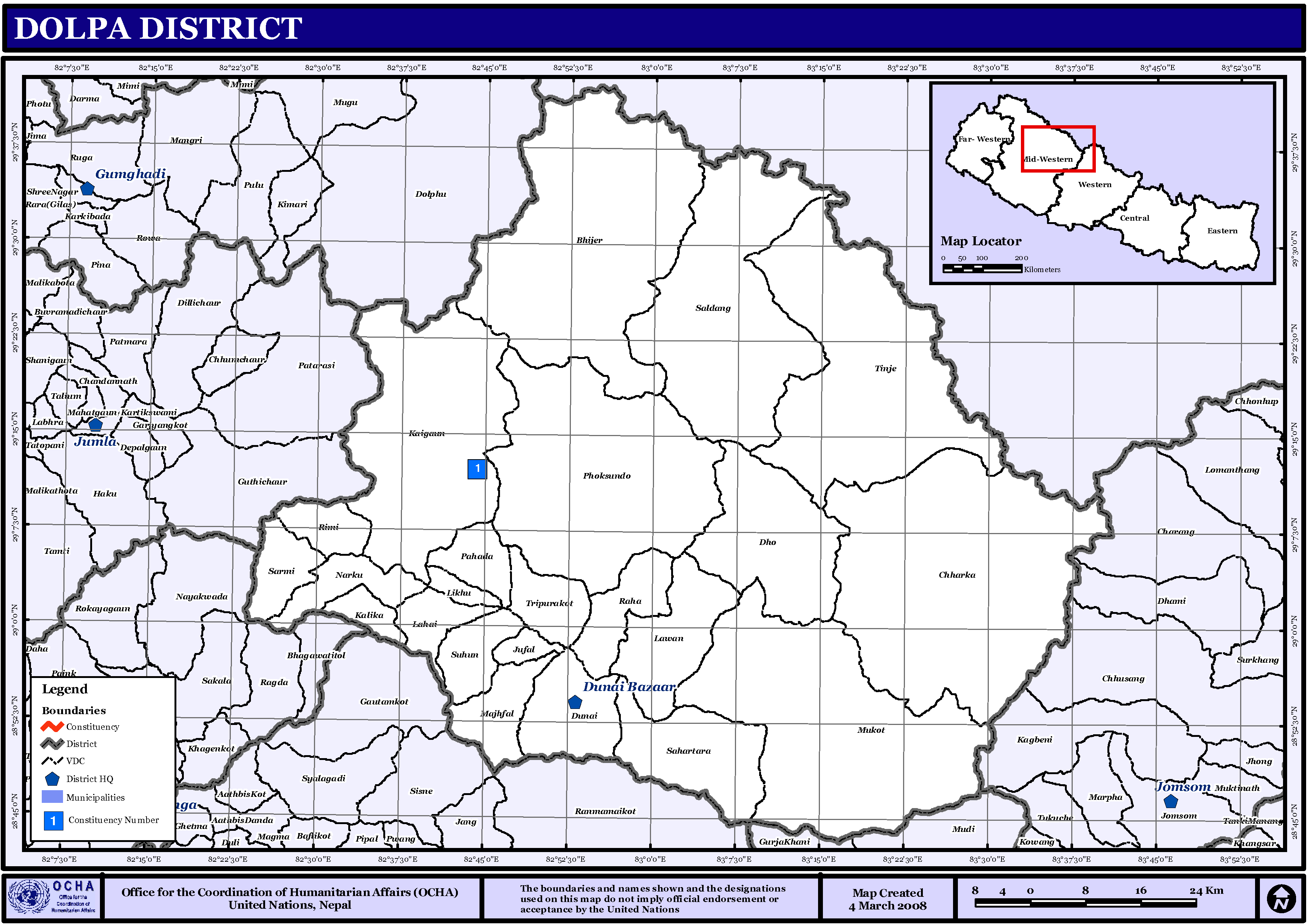
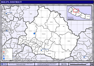 Map of the VDCs in Dolpa District
- Bhijer
- Chharka
- Dho
- Dunai
- Jufal
- Kaigaun
- Kalika
- Khadang
- Lawan
- Likhu
- Majhfal
- Mukot
- Narku
- Pahada
- Phoksundo
- Raha
- Rimi
- Sahartara
- Saldang
- Sarmie
- Sunhoo
- Tinje
- Tripurakot
See also
External links
Districts of Nepal Achham · Arghakhanchi · Baglung · Baitadi · Bajhang · Bajura · Banke · Bara · Bardiya · Bhaktapur · Bhojpur · Chitwan · Dadeldhura · Dailekh · Dang Deokhuri · Darchula · Dhading · Dhankuta · Dhanusa · Dolkha · Dolpa · Doti · Gorkha · Gulmi · Humla · Ilam · Jajarkot · Jhapa · Jumla · Kailali · Kalikot · Kanchanpur · Kapilvastu · Kaski · Kathmandu · Kavrepalanchok · Khotang · Lalitpur · Lamjung · Mahottari · Makwanpur · Manang · Morang · Mugu · Mustang · Myagdi · Nawalparasi · Nuwakot · Okhaldhunga · Palpa · Panchthar · Parbat · Parsa · Pyuthan · Ramechhap · Rasuwa · Rautahat · Rolpa · Rukum · Rupandehi · Salyan · Sankhuwasabha · Saptari · Sarlahi · Sindhuli · Sindhulpalchok · Siraha · Solukhumbu · Sunsari · Surkhet · Syangja · Tanahu · Taplejung · Terhathum · Udayapur
 Categories:


Wikimedia Foundation. 2010.