- Rukum District
Infobox Nepal district
district = Arghakhanchi District
area = 2,877km²
population = 188,438
pop_year = 2001
density =
caption = Rukum district expanded from the map of Nepal
region =
established =
languages =
website =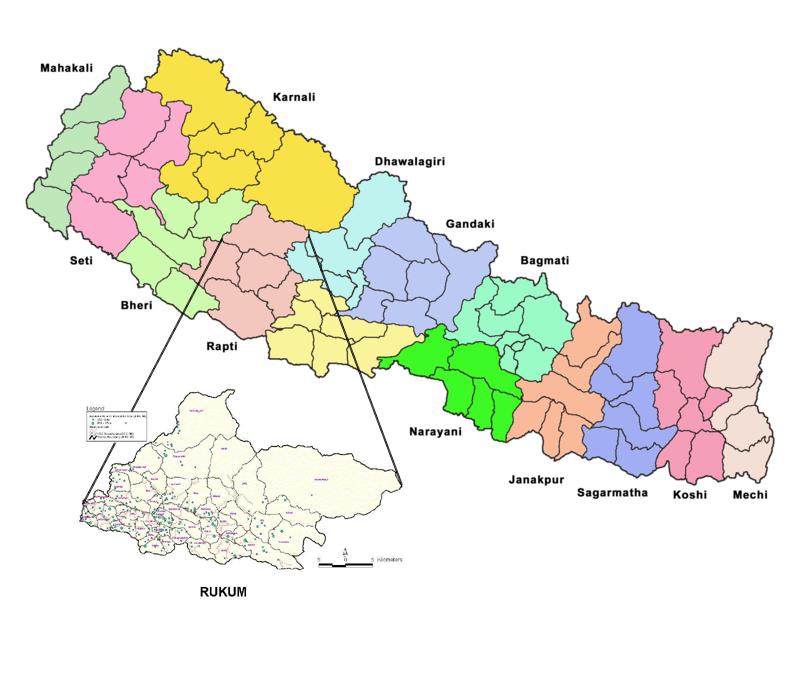
Rukum District, a part of
Rapti Zone , is one of the seventy-five districts ofNepal , alandlocked country ofSouth Asia . The district, with Musikot (also called Jhumlikhalanga) as its district headquarters, covers an area of 2,877km² and has a population (as of2001 ) of around 188,438.Rukum district has many could-be-tourist-spots places, but due lack of information, many of them remain unexplored. One of the main place that could have been the major tourist destination is Mt. Sisne (सिस्ने हिमाल) also called virgin mountain, as nobody has claimed to have conquered this mountain yet. Rukum is also called The place of 'Baunna Pokhari Tripanna Takuri', means the place of 52 lakes and 53 hills .Rukumkot is the most attractive tourist destination in Rukum District in Nepal. There is very beautiful Pond called Rukmini Tal (local name Kamal Dhaha) and there are a lot of mysterious caves surrounding the beautiful village Rukumkot. Among them Deurali Cave is very interesting and mysterious,is situated in eastern part of Rukumkot.It is really attractive valley having natural beauties ever.There is a beautiful Temple called Barah Temple and one more historic temple Sibalaya near by Rukmini Tal.Introduction
All the talking about this district will be almost worthless if we don't mention the Maoist insurgency which supposedly initiated from this district and
Rolpa , along with the name of Rukum. It remained the stronghold and heartland of the Maoist insurgents for the entire period of the insurgency. Many of the main leaders of Maoist are from this district and many insurgents who died during the decade long war are also from this district.Transportation Media
Rukum District is considered remote, in no small part because air travel is the only modern transportation mode available there. The district's two airports offer safe but rudimentary facilities for passenger flights, mainly from Nepalgunj, Bhairahawa and Kathmandu. Otherwise, access from Rukum to major highways and population centers requires up to several days' hiking. During the monsoon months, this can be hazardous even for seasoned locals.
In the past few years however, some roads have been constructed that will eventually enable motor vehicle access to this district. As is the case with many rural infrastrucutre projects in Nepal, this is proceeding at a snail's pace.
The two airports in Rukum are in Chaurjahari (चौरजहारी) and the more recently constructed airport in Salle (सल्ले).
Chaurjahari Airport
Chaurjahari is situated on the banks of the
Bheri river between Salyan and Jajarkot districts.
The town's airport is 762m above sea level and accessible by footpaths and horse trails only, with a grass runway 488m long and 30m wide. It was the primary mode of travel to Rukum for government/NGO/aid workers and off-the-beaten-track backpackers before the civil war, which officially ended in 2006. During that time, the security situation deteriorated and the local police station was shut down. As a consequence the airport was frequently inoperable.Rukum Salle Airport
This airport is located near Musikot, the district headquarters. Like Chaurjahari, it is also accessible only by footpaths and horse trails. The airport has a gravel runway.
References
*
Wikimedia Foundation. 2010.