- Dang Deukhuri District
-
Dāng-Deukhurī Jillā
दाङ-देउखुरी जिल्ला— District — Dang-Deukhuri (red)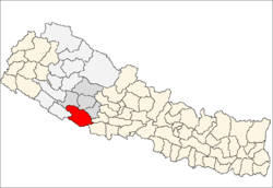
Country  Nepal
NepalRegion Mid-Western (grey) Zone Rapti (darker grey) Area – Total 2,955 km2 (1,140.9 sq mi) Population (2001) – Total 462,380 – Density 156.5/km2 (405.3/sq mi) Time zone NPT (UTC+5:45) Main language(s) Nepali, Awadhi Coordinates: 28°0′N 82°16′E / 28°N 82.267°E Dang-Deukhuri, (Biggest Valley in South Asia) District is an Inner Terai district some 280 km west of Kathmandu in Rapti Zone of Nepal's Mid-Western Region. Dang-Deukhuri covers an area of 2,955 km² with population (2001) of 462,380. Tribhuwannagar (usually called Ghorahi) is the district's administrative center.
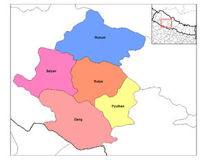 Rapti Zone districts with Dang-Deukhuri at bottom
Contents
Geography
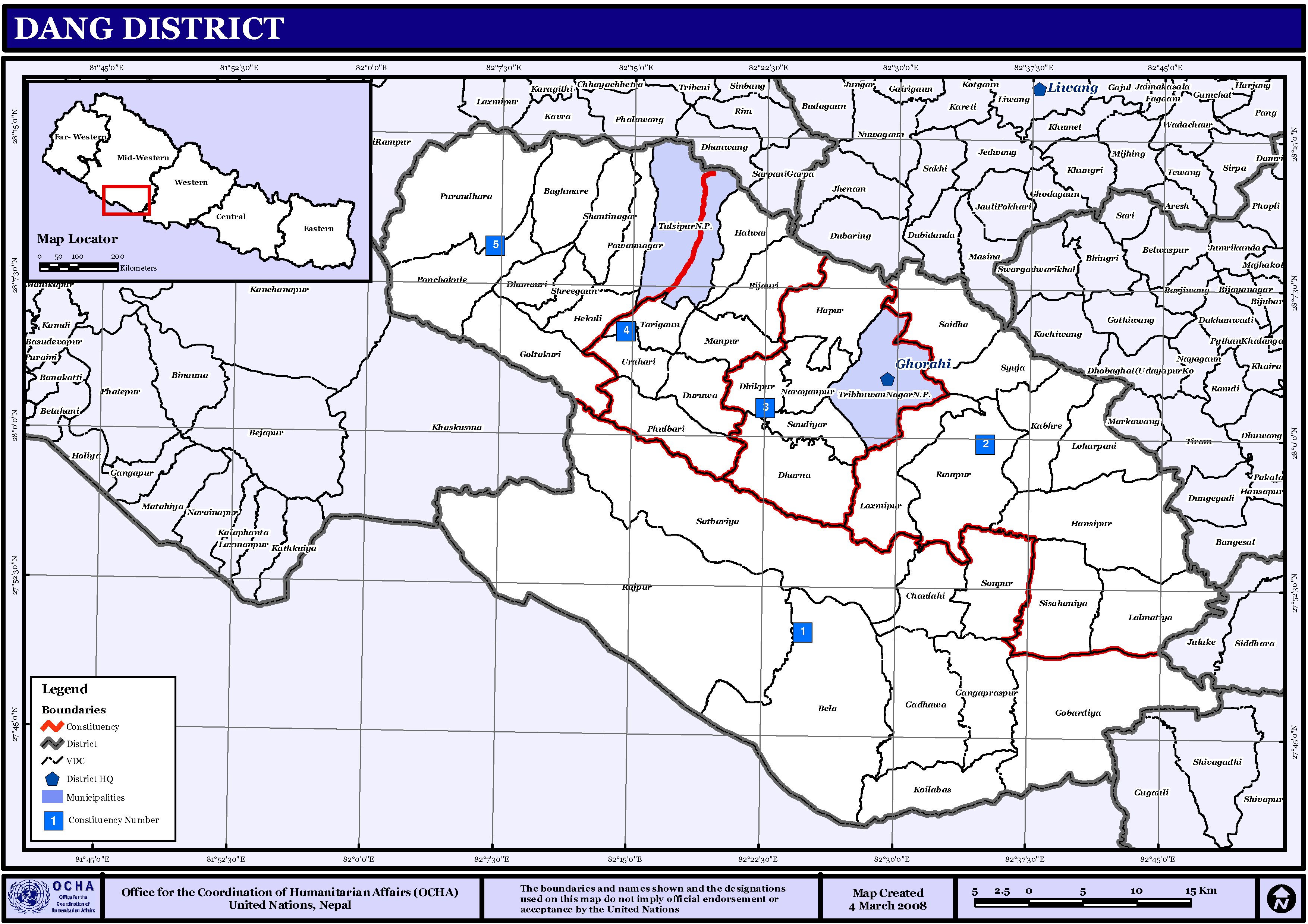
This district consists of the larger easterly and upstream portions of parallel Inner Terai valleys, Dang and Deukhuri, plus enclosing ranges of hills and mountains. Downsteam, both valleys cross into Banke District, Bheri Zone.
To the south, the district borders Uttar Pradesh, India -- specifically Balarampur and Shravasti districts of Awadh. Because the international border follows the southern edge of the outermost Siwalik foothills called the Dudhwa Range, there is no Nepalese Outer Terai extending onto the main Ganges Plain in this district. The permeable geology of the Siwaliks does not support moisture retention or soil development so they are covered with unproductive scrub forest.
The Dudhwas rise steeply to a crest at about 700 meters then slope down gradually into Deukhuri Valley, to 250 meters at the Rapti River. The Dudhwas extend more than 100 km, causing the Rapti to detour west around them before turning SE down the overall trend of the plains into India. Deukhuri's climate is nearly tropical and it is well watered by the river as well as abundant groundwater.
North of Deukhuri Valley the Dang Range rises to peaks as high as 1,000 meters with passes at about 700 meters. Dang Valley lies north of these hills, at elevations from 600 meters along the Babai River with alluvial slopes gradually rising northward to 700 meters along the base of the Mahabharat Range. Then the district extends upslope to the crest of the Mahabharats at 1,500 to 1,700 meters elevation. Bordering districts to the north are Pyuthan, Rolpa and Salyan.
Transportation
Mahendra Highway -- the main east-west highway across Nepal -- follows Deukhuri Valley, passing Bhalubang bazar at the upper end and Lamahi downstream. From Bhalubang, branch roads lead up the Rapti River into Pyuthan and Rolpa Districts. From Lahami there are roads north across the Dang Range to Tulsipur and Tribuvannagar, and south over the Dudhwas to Koilabas bazaar on the international border where goods enter Rapti Zone from India. At Tulsipur, all-weather [TARIGAUN AIRPORT ABOT 1.5 KM FAR FROM TULSIPUR] has scheduled connections to other cities in Nepal and a motorable road goes north into Salyan District.
Demography
The droughty and agriculturally unproductive Dudhwa range creates a buffer zone between the divergent cultures of the plains of Uttar Pradesh and the Inner Terai. Deukhuri was severely malarial before the late 1950s when DDT came into use to suppress mosquitos so that Tharu people who had evolved resistance managed to live in isolation from more developed and avaricious cultures of the plains to the south and the hills to the north. Although road development further reduced Deukhuri's isolation by the 1980s, the valley retains some of its Garden of Eden charm with its lazy river, thick jungle alternating with rice paddies, surrounding hills in the middle distance, and unique peoples.
Dang Valley is higher, less tropical, drier and less malarial than Deukhuri. Despite poorer soil and more seasonal streamflow, its healthier climate made it more attractive to settlers from outside even before the introduction of DDT.
Since the early 1990s activist groups have been attempting to eradicate the practice of child indentured servitude among the Tharu, many of whom sold young daughters to wealthy families in urban areas.[1]
The steep, virtually uninhabited southern slopes of the Mahabharat Range are another cultural buffer zone between traditional Tharu lands and the culturally distinct Middle Hills where Nepali is the dominant language, the homeland of Nepal's politically dominant Bahuns and Chhetris.
History
Towns and villages
 VDCs in Dang-Deokhuri
- Amritpur
- Baghmare, Bela, Bijauri
- Chailahi, Lamahi
- Dhanauri, Dharna, Dhikpur, Duruwa
- Gadhawa, Gangaparaspur, Goltakuri, Gobardiya
- Halwar, Hansipur, Hapur, Hekuli,
- Kabhre, Koilabas
- Lalmatiya, Laxmipur, Loharpani
- Manpur
- Narayanpur
- Panchakule, Pawan Nagar, Phulbari, Purandhara,
- Rajpur, Rampur,
- Saigha, Satbariya, Saudiyar, Shantinagar, Shreegaun, Sisahaniya, Sonpur, Syuja
- Tarigaun, Tribhuwan Nagar, Tulsipur
- Urahari
- Bhalubang: This town is on the eastern side of the Deukhuri valley. It lies on the side of Rapti river.
- Maurighat, Sisahaniya
Historic, cultural and archeological sites[2]
- Amarai Temple, Ambikswari Temple
- Barakune Daha
- Chhilli kot, Chhilli Kot Gupha
- Dharapani
- Hanuman Temple
- Kalimai Temple
- Mulkot Cave
- Ram Janaki Temple, Ratnanath
- Sirasthan, Srigaun Temple, Sukaura Mound
- Taptakunda Shivalaya
- Shiva Mandir, Dhankhola,
- Shiva Cave, Dhankhola,
- Mata Malmala Devi
- Jakhera Tal Temple (Narayan puri)
- House of Tulsipur - Formerly Tulsipur-Dang, one of 22 Principalities in Nepal and later on known as One of Taluqs of Oudh in India
References
- Districts of Nepal at statoids.com
- House of Tulsipur
- ^ Desperate plight of Nepal 'slave girls' BBC News, 2 March 2007
- ^ Bhandari, Bishnu, ed (1997). Inventory of heritage sites in Nepal. Kathmandu: IUCN Nepal. http://data.iucn.org/dbtw-wpd/exec/dbtwpub.dll?AC=GET_RECORD&XC=/dbtw-wpd/exec/dbtwpub.dll&BU=http%3A%2F%2Fdata.iucn.org%2Fdbtw-wpd%2Fcommande%2Findex_newsite.htm&TN=iucn&SN=AUTO463&SE=612&RN=0&MR=20&TR=0&TX=1000&ES=0&CS=1&XP=&RF=WebRes&EF=&DF=WebAff&RL=0&EL=0&DL=0&NP=254&ID=&MF=&MQ=&TI=0&DT=&ST=0&IR=1832&NR=0&NB=0&SV=0&BG=&FG=&QS=&OEX=ISO-8859-1&OEH=ISO-8859-1. Retrieved April 15, 2011.
Districts of Nepal Achham · Arghakhanchi · Baglung · Baitadi · Bajhang · Bajura · Banke · Bara · Bardiya · Bhaktapur · Bhojpur · Chitwan · Dadeldhura · Dailekh · Dang Deokhuri · Darchula · Dhading · Dhankuta · Dhanusa · Dolkha · Dolpa · Doti · Gorkha · Gulmi · Humla · Ilam · Jajarkot · Jhapa · Jumla · Kailali · Kalikot · Kanchanpur · Kapilvastu · Kaski · Kathmandu · Kavrepalanchok · Khotang · Lalitpur · Lamjung · Mahottari · Makwanpur · Manang · Morang · Mugu · Mustang · Myagdi · Nawalparasi · Nuwakot · Okhaldhunga · Palpa · Panchthar · Parbat · Parsa · Pyuthan · Ramechhap · Rasuwa · Rautahat · Rolpa · Rukum · Rupandehi · Salyan · Sankhuwasabha · Saptari · Sarlahi · Sindhuli · Sindhulpalchok · Siraha · Solukhumbu · Sunsari · Surkhet · Syangja · Tanahu · Taplejung · Terhathum · Udayapur
 Categories:
- Dang Deokhuri District
- Nepal geography stubs


Wikimedia Foundation. 2010.