- Morang District
-
Morang
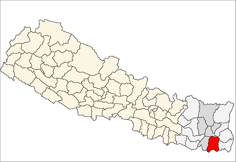
मोरङ— District — Location of Morang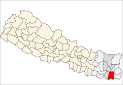
Country  Nepal
NepalRegion Eastern (Purwanchal) Zone Kosi Area - Total 1,855 km2 (716.2 sq mi) Population (2001) - Total 843,220 - Density 454.6/km2 (1,177.3/sq mi) Time zone NPT (UTC+5:45) Main language(s) Limbu, Maithali, Nepali Morang District(Nepali: मोरङ जिल्ला
 Listen (help·info), a part of Kosi Zone, is one of the seventy-five districts of Nepal, a landlocked country of South Asia. The district, with Biratnagar as its district headquarters, covers an area of 1,855 km² and has a population (2001) of 843,220.
Contents
Geography
Morang lies in the southern Tarai, or plains, of Eastern Nepal. Most of the land is taken up by rice and jute cultivation, though areas of sal forest remain along the northern part of the district where the plains meet the hills. A large amount of the forest was cleared in the last century, and in the process, many settlers migrated to the district from the hills and India. The Morang plains are one of the most culturally diverse regions in Nepal. The district neighbours India to the south, and the districts of Sunsari to the west and north, Jhapa to the east, and Dhankuta to the north east.
Economy
Most of the district is rural, though it is also home to Biratnagar, the 2nd largest city in Nepal after Kathmandu. Other minor towns include Urlabari, Biratchowk and Rangeli. It also boasts the largest industrial area in the whole country, expanding from Rani Mills Area to Duhabi River. Raghupati Jute Mills and Dhanawat Matches are among the nation's oldest industries.
Education
Morang district is home to the historic Morang Campus and several other institutions of higher learning. The recent opening of Purvanchal University in Biratnagar, which offers graduate level courses in many disciplines of Arts and Liberal Sciences, is certain to make the place a college town as it attracts college graduates from most of the eastern part of the nation.
History
The name Morang is derived from the name of the Limbu King Mawrong Mung Hang,<ref: History of Limbuwan> who established Morang Kingdom in the beginning of seventh century. His capital and fort was at Rongli, present day Rangeli. Morang was then annexed to greater Limbuwan by King Uba hang in 849 CE and ruled until 1584 CE when Limbu King Sangla Ing made Morang independent and ruled from Varatappa situated east of Modern Bijaypur. The Ing Dynasty and followed by Sen dynasty then Khebang dynasty ruled Morang until 1774 CE. Morang name fell from use after the annexation of all the Kingdoms of Limbuwan including Morang by King Prithivi Narayan Shah of Gorkha. The last King of Morang was Buddhi Karna Raya Khebang, who ruled from Bijaypur near Dharan.
The Kingdom of Morang, until its annexation to the Gorkha Kingdom of King Prithivi Narayan Shah, comprised all the terai lands east of the Koshi River and west of the Mechi River.
The name Morang came into use again after the shah kings divided the country into administrative districts and Morang was named after the old Morang Kingdom.
Morang District is a southeastern district of Nepal and has a diversity of cultures and religions. It has a long history dating from the ninth century.[clarification needed][citation needed]
Politics
Morang has been a hotbed of political activity throughout Nepal's recent history producing political stalwarts such as BP Koirala, Girija Prasada Koirala, Man Mohan Adhikari, Bharat Mohan Adhikari, Upendra Yadav amongst others. The district currently sends 9 members to the national legislature.
Sub-Metropolitan City
Municipality
- Urlabari
Village Development Committees (VDCs)
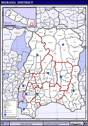 Map of the VDCs in Morang District
- Amaibariyati
- Amardaha
- Amgachhi
- Babiya Birta
- Bahuni
- Bairban
- Banigama
- Baradanga
- Bayarban
- Belbari
- Bhaudaha
- Bhogateni
- Budhanagar
- Dainiya
- Dangihat
- Dangraha
- Darbairiya
- Drabesh
- Dulari
- Govindapur
- Haraicha
- Hasandaha
- Hathimudha
- Hoklabari
- Indrapur
- Itahara
- Jante
- Jhapa Baijanathpur
- Jhorahat
- Jhurkiya
- Kadamaha
- Kaseni
- Katahari
- Kathamaha
- Kerabari
- Keron
- Lakhantari
- Letang
- Madhumalla
- Mahadeva
- Majhare
- Matigachha
- Motipur
- Mrigauliya
- Necha
- Pathari
- Patigaun
- Pokhariya
- Rajghat
- Ramite Khola
- Rangeli
- Sanischare
- Sidharaha
- Sijuwa
- Sinhadevi Sombare
- Sisabanibadahara
- Sisawanijahada
- Sorabhaj
- Sundarpur
- Takuwa
- Tandi
- Tankisinuwari
- Tetariya
- Thalaha
- Warangi
- Yangshila
References
- Districts of Nepal at statoids.com
Districts of Nepal Achham · Arghakhanchi · Baglung · Baitadi · Bajhang · Bajura · Banke · Bara · Bardiya · Bhaktapur · Bhojpur · Chitwan · Dadeldhura · Dailekh · Dang Deokhuri · Darchula · Dhading · Dhankuta · Dhanusa · Dolkha · Dolpa · Doti · Gorkha · Gulmi · Humla · Ilam · Jajarkot · Jhapa · Jumla · Kailali · Kalikot · Kanchanpur · Kapilvastu · Kaski · Kathmandu · Kavrepalanchok · Khotang · Lalitpur · Lamjung · Mahottari · Makwanpur · Manang · Morang · Mugu · Mustang · Myagdi · Nawalparasi · Nuwakot · Okhaldhunga · Palpa · Panchthar · Parbat · Parsa · Pyuthan · Ramechhap · Rasuwa · Rautahat · Rolpa · Rukum · Rupandehi · Salyan · Sankhuwasabha · Saptari · Sarlahi · Sindhuli · Sindhulpalchok · Siraha · Solukhumbu · Sunsari · Surkhet · Syangja · Tanahu · Taplejung · Terhathum · Udayapur
 Categories:


Wikimedia Foundation. 2010.