- Gandaki River
-
Gandaki (Kali) Narayani River 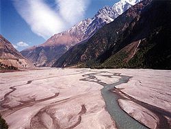 Kali Gandaki River, Nepal
Countries Tibet (China), Nepal, India Tributaries - left Trishuli, Budigandaki, Marshyandi, Madi, Seti River - right Kaligandaki, Badigad Cities Lo Manthang, Jomsom, Beni, Nepal[disambiguation needed  ], Kusma, Nepal, Ridi, Devghat, Narayangarh, Valmikinagar, Triveni, Hajipur, Sonepur
Source Nhubine Himal Glacier - location Tibet-Mustang border, Nepal - elevation 6,268 m (20,564 ft) - coordinates 29°17′0″N 85°50′5″E / 29.283333°N 85.83472°E Mouth Ganges - location Sonepur, India - elevation 44 m (144 ft) - coordinates 25°39′9″N 85°11′4″E / 25.6525°N 85.18444°E Length 630 km (391 mi) Basin 46,300 km2 (17,877 sq mi) Discharge - average 1,760 m3/s (62,154 cu ft/s) - max 30,000 m3/s (1,059,440 cu ft/s) - min 500 m3/s (17,657 cu ft/s) 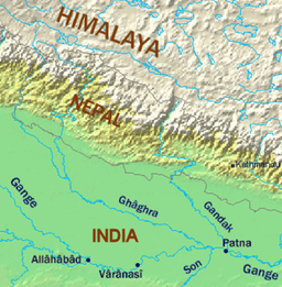 Map showing the Ghaghara and Gandaki tributaries of the Ganges.
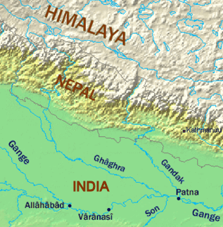
The Kali Gandaki or Gandaki River (also known as the Narayani in southern Nepal and the Gandak in India) is one of the major rivers of Nepal and a left bank tributary of the Ganges in India It is also called Krishna Gandaki in Nepal.[1] In Nepal the river is notable for its deep gorge through the Himalayas and its enormous hydroelectric potential. It has a total catchment area of 46,300 square kilometers (17,900 sq mi), most of it in Nepal. It lies between the similar Kosi system to the east and the Karnali (Ghaghara) system to the west.
Contents
River course
Nepal
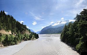
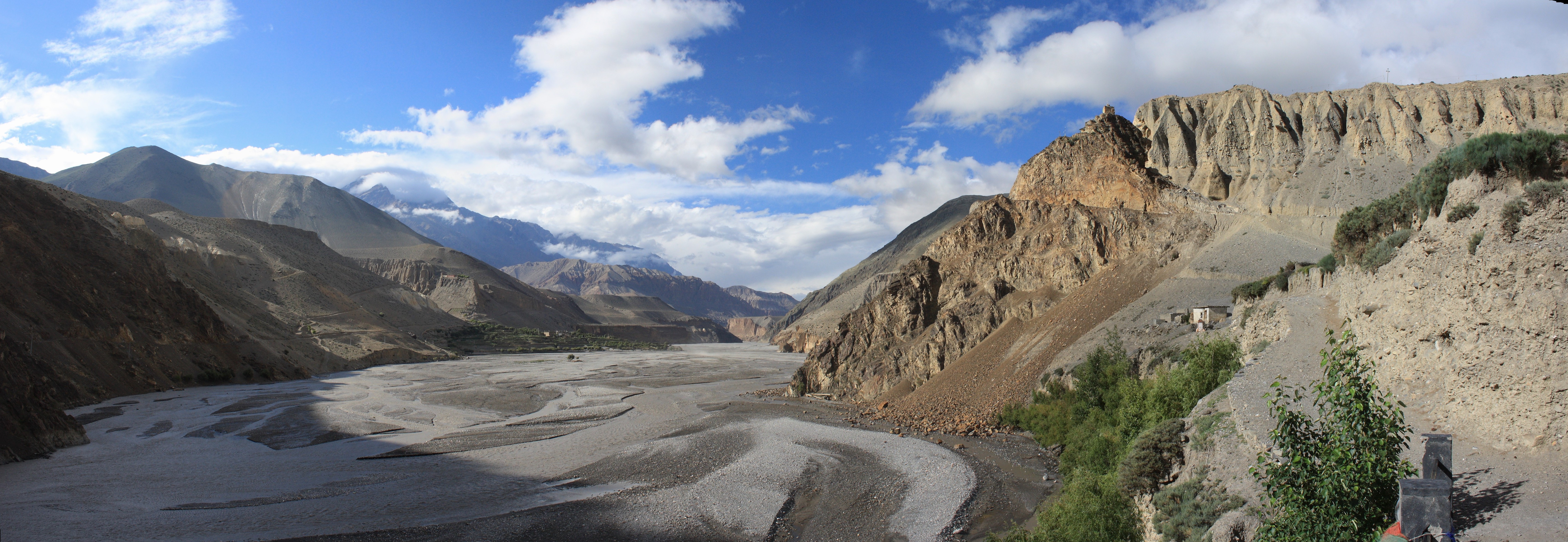
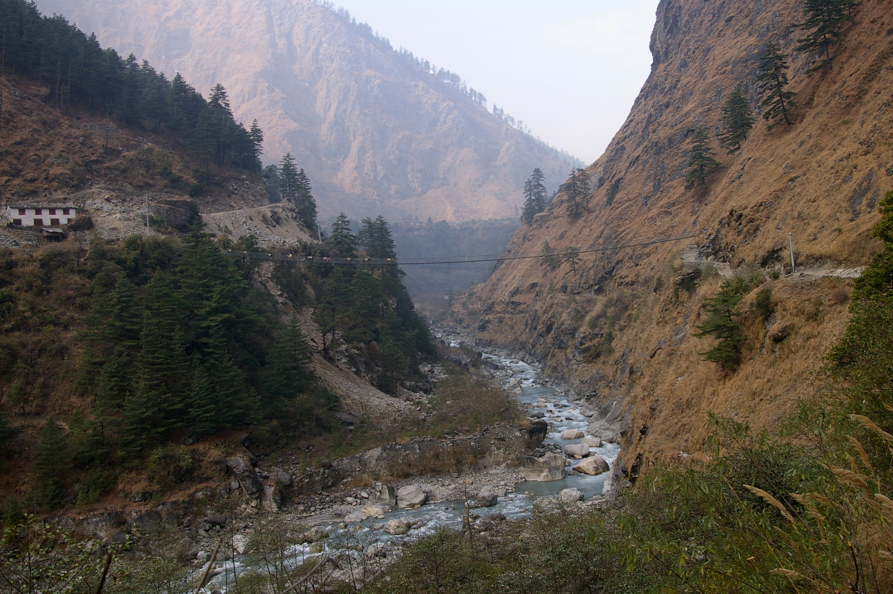
 In Nepal, the river quickly crosses different zones of climate. Here it's in a pretty dry desert-like area ...
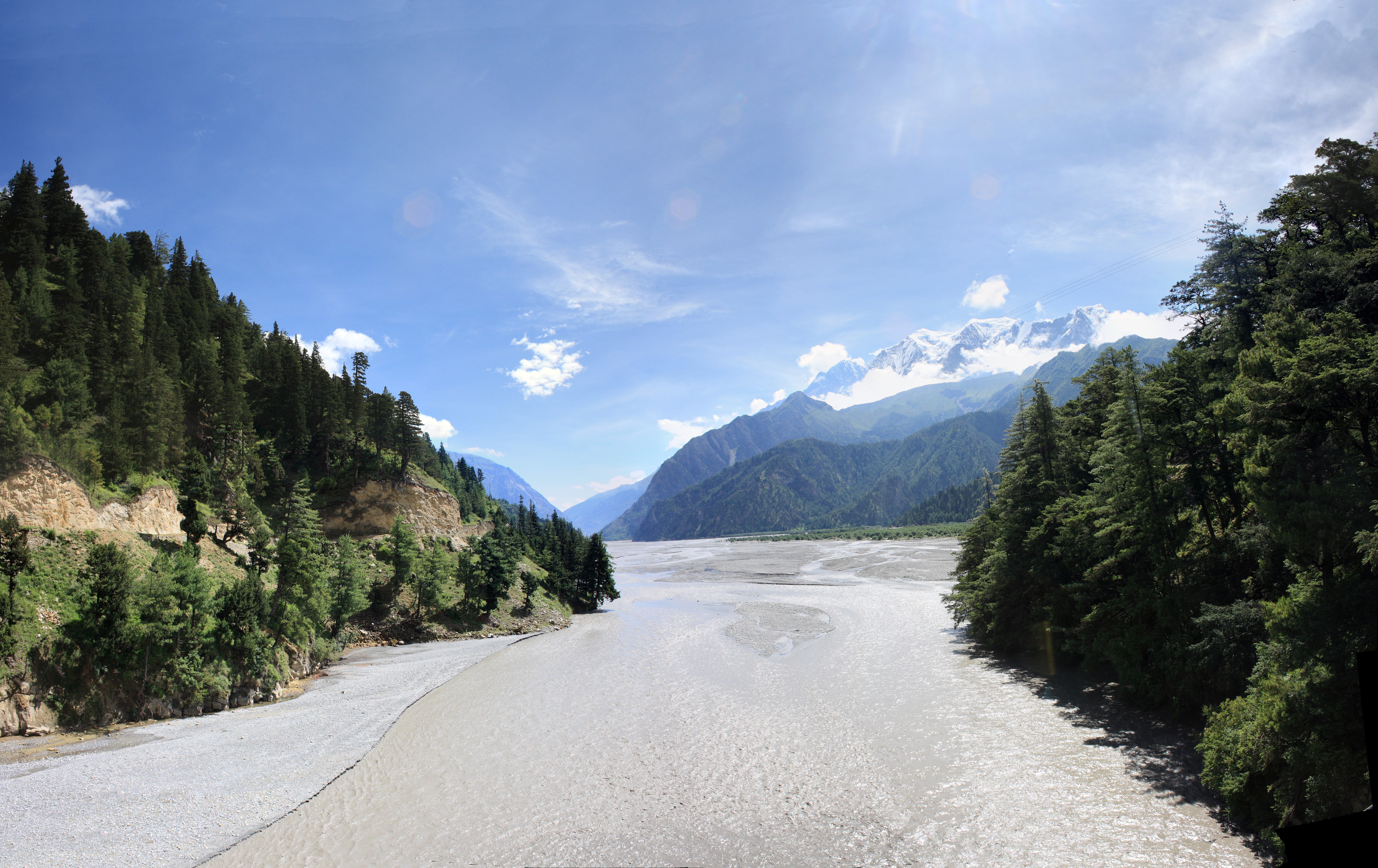
 ... and here, just 25 km downstream of the place above it flows through a pine forest.
The river is called Sapta (seven) Gandaki for seven tributaries rising in the Himalaya or further north along the main Ganges-Brahmaputra divide. These are called Daraudi, Seti, Madi, Kali, Marsyandi, Budhi, and Trisuli.
The Kali Gandaki river source is at the border with Tibet at an altitude of 6,268 m (20,564 ft) at the Nhubine Himal Glacier in the Mustang region of Nepal.[2][3]
The headwaters stream on some maps is named the Chhuama Khola and then, nearing Lo Manthang, the Nhichung Khola or Choro Khola. The Kali Gandaki then flows southwest (with the name of Mustang Khola on old, outdated maps) through a sheer-sided, deep canyon before widening at the steel footbridge at Chele, where part of its flow funnels through a rock tunnel, and from this point the now wide river is called the Kali Gandaki on all maps. In Kagbeni a major tributary named Johng Khola or Kak Khola descends from Muktinath.
The river then flows southward through a steep gorge known as the Kali Gandaki Gorge, or Andha Galchi, between the mountains Dhaulagiri (8167 m) to the west and Annapurna I (8091 m) to the east. If one measures the depth of a canyon by the difference between the river height and the heights of the highest peaks on either side, this gorge is the world's deepest. The portion of the river directly between Dhaulagiri and Annapurna I (7 km downstream from Tukuche) is at an elevation of 2520 metres,[4] 5571 metres lower than Annapurna I. The river is older than the Himalayas. As tectonic activity forces the mountains higher, the river has cut through the uplift.
South of the gorge, the river is joined by Rahughat Khola at Galeshwor, Myagdi Khola at Beni, Modi Khola near Kushma and Badigaad at Rudrabeni above Ridi Bazaar. The river then turns east to run along the northern edge of the Mahabharat Range. The largest hydroelectricity project in Nepal is located along this stretch of the river. Turning south again and breaking through the Mahabharats, Kali Gandaki is then joined by a major tributary, Trishuli at Devighat,The trisuli river is already mixed with five tibutaries named budugandaki,marshyandi,daraudi,seti and madi, then by the (East) Rapti draining the Inner Terai valley known as Chitwan. The Gandaki then crosses the outermost foothills of the Himalayas—Sivalik Hills—into the Terai plains of Nepal. From Devighat, the river flows southwest and is known as Narayani or Sapt Gandaki. The river later curves back towards the southeast as it enters India where it is called the Gandak.
India
The entry point of the river at the Indo-Nepal border is also the confluence called Triveni with rivers Pachnad and Sonha descending from Nepal. Pandai river flows into Bihar (India) from Nepal in the eastern end of the Valmiki Sanctuary and meets Masan. The Gandak flows southeast 300 km across the Gangetic plain of Bihar state through Champaran, Gopalganj, Saran and Muzaffarpur districts. It joins the Ganges near Patna just downstream of Hajipur at Sonepur (also known as Harihar Kshetra). Its drainage area in India is 7620 km2.
From its exit from the outermost Siwaliks foothills to the Ganges, the Gandak has built an immense megafan comprising Eastern Uttar Pradesh and North Western Bihar in the Middle Gangetic Plains.[5] The megafan consists of sediments eroded from the rapidly-uplifting Himalaya. The river's course over this structure is constantly shifting. It is said[who?] that the river has shifted 80 km to the east due to tectonic tilting in the last 5,000 years.
Glaciers, glacial lakes and glacial lake outburst floods
The Gandaki river basin is reported to contain 1025 glaciers and 338 lakes. These contribute substantially to the lean season flows of the river.
Glacier lakes, among the most hazardous features of high mountains, are usually formed behind dams of moraine debris left behind by retreating glaciers, a trend that is observed all over the world. Even though glacial lake outburst flood (GLOF) events have been occurring in Nepal for many decades, the Dig Tsho glacier outburst, which took place in 1985, has triggered detailed study of this phenomenon. In 1996, the Water and Energy Commission Secretariat (WECS) of Nepal reported that five lakes were potentially dangerous, namely, Dig Tsho, Imja, Lower Barun, Tsho Rolpa, and Thulagi, all lying above 4,100 metres (13,500 ft). A recent study done by ICIMOD and UNEP (UNEP, 2001) reported 27 potentially dangerous lakes in Nepal. In ten of them GLOF events have occurred in the past few years and some have been regenerating after the event.
Thulagi glacier
The Thulagi glacier, which is located in the Upper Marsyangdi River basin, is one out of the two moraine-dammed lakes (supra-glacial lakes), identified as a potentially dangerous lake. The KfW, Frankfurt, the BGR (Federal Institute for Geosciences and Natural Resources, Germany), in cooperation with the Department of Hydrology and Meteorology in Kathmandu, have carried out studies on the Thulagi Glacier and have concluded that even assuming the worst case, a disastrous outburst of the lake can be excluded in the near future.[6]
Important towns
Major towns and cities located along or near the banks of the Kali Gandaki are Lo Manthang, Jomsom, Beni[disambiguation needed
], Baglung, Kusma, Ridi, Devghat, Narayangarh, Valmikinagar and Triveni. The river also forms the western border of Chitwan National Park. Gorkha is an important town in the Trisuli river basin. Along the stretch in Nepal, the river carries heavy amounts of glacial silt, imparting the river a black color. Kali Gandaki, Marshyandi,Seti,is a popular whitewater adventure destination.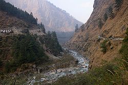
The important towns in the Indian part of the Gandak river are the Valmikinagar(Bhainsalotan)- location of Gandak Barrage, Bagaha, Bettia (district hqrs & field directorate of Valmiki Tiger Project), Harinagar (Ramnagar), Hajipur (across the Ganges 10 km from Patna) and Sonepur (also Known as Harihar Kshetra), near Patna.
In traditional and popular culture
- The Gandaki river is mentioned in the ancient Sanskrit epic Mahabharata.
- Episode 1 of "The Living Planet," David Attenborough's second nature documentary series, is set in the Kali Gandaki Gorge.
National Parks
Chitwan National Park of Nepal and Valmiki National Park of India are adjacent to each other in the vicinity of Valmikinagar around the Gandak Barrage.
Chitwan National Park
Royal Chitwan National Park IUCN Category II (National Park)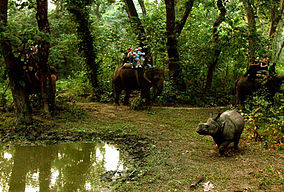
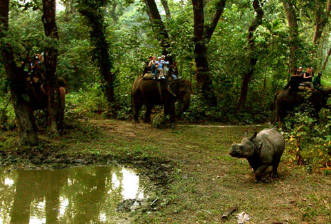
Elephant safari after One horned rhinosChitwan National Park covers an area of 932 km² and is the oldest national park of Nepal established in 1973. It was granted the status of a World Heritage Site in 1984. It is located in Chitwan, one of the Inner Terai Valleys of Nepal. The park is rich in flora and fauna, including Bengal Tigers and one of the last populations of single-horned Indian Rhinoceros (Rhinoceros unicornis). The area used to be known as the Chitwan Valley. It was a place for big game hunting and until 1951 it was a hunting reserve. At the park there is canoeing, elephant rides, and guided jungle walks.
Valmiki National Park
Valmiki sanctuary covers about 800 km² of forest and is the 18th Tiger Reserve[projecttiger.nic.in/valmiki.htm] of the country and ranked fourth in terms density of Tiger population. Valmikinagar is located nearly 100 km from Bettiah in the northernmost part of the West Champaran district, bordering Nepal. Valmikinagar is a small town with scattered habitation, mostly within the forest area and has a railroad station in the district of West Champaran, close to the railhead of Narkatiaganj.It has diverse landscapes, sheltering rich wildlife habitats and floral and faunal composition with the prime protected carnivores and was included in the National Conservation Programme of the Project Tiger in the year 1994.As per Zoological Survey of India's report of 1998 the Sanctuary is reported to shelter 53 mammals, 145 birds, 26 reptile & 13 amphibians.[7] and Tiger Reserve[8]
The notable species of Wild Fauna include: Tiger, Leopard, Wild dog" Wild boar, Bison,Bear, Peacock, Partridge, Hornbill, Hill mynah,Woolly-necked stork, python, Crocodile, Deer,Sambar, Blue bull, Barking deer, Hog deer.
As per the Botanical Survey of India report 1998 there are seven types of vegetation consisting of seven classes of forests; home to 84 species of trees (subtropical trees such as Sal, Sagwan, Bamboo, Cane, etc.), 32 shrubs and climbers and 81 herbs and grasses.
Religious significance
Valmiki Ashram
The ancient Valmiki Ashram (hermitage) and surrounding temples are located in the Chitwan National Park of Nepal.It is located at a distanace of about 7 km from Valmikinagar. It is approachable for pilgrimage only from Valmikinagar near Gandak Barrage, both from Nepal and India.
It is said that Valmiki Rishi (sage) wrote the great epic, "Ramayana" here. It is also believed to be the birthplace of Luv & Kush (the two sons of Lord Ram and his divine wife Sita. The hermitage also has landmarks of Sita’s ‘Falahar’ (eating place), Meditation place of the great Sage-Valmiki, the place where the Ashwamedh horse was tied, Amrit (nectar of immortality) Kuan (well); Vishnu Chakra (disc), and the Hawan (Yagna) Kund (sacred square structure to perform fire rituals).
In the periphery of 3 to 4 kilometres (1.9 to 2.5 mi) around the Valmiki Ashram, the temples of importance are a) the Jatashankar (Shiv[disambiguation needed
]) Temple, 2) Nardevi (Sweta Kali)Temple (Form of Durga and 3) Kaleshwaran (an avatar of the God Shiva) Temple. Triveni Temple is located across the Gandak Barrage in Nepal, about 3 km from the Gandak Barrage.Saligrama Sila and Mukthinath
The stones (Ammonite fossils) collected from the bed of the Gandaki River at a place close to Saligrama or Muktinath (literally meaning "place of salvation") in the Mustang district of Nepal, (where a Hindu shrine of the Shrivaishnava sect founded by the great seer Ramanuja exists) are called Saligram Silas and considered unique and are used for worship. It is also a sacred place for Buddhists who call it Chumig Gyatsa, which in Tibetan means 'Hundred Waters'..Muktinath is also called by the Hindus as Mukthiksehtra, which literally means "place of salvation".
These stones are naturally formed round stones, with circular or spiral markings and are fossil ammonite stones found in the rivers of Himalayas, in particular kinds of ocean sediments, which have been uplifted to the top of the Himalayas.
Located between the Dhaulagiri and Annapurna mountain ranges, the Gandaki River flows through the village of Saligrama or Muktinath and the Ashrama of Pulaha. In ancient times, the mountain range surrounding Pulaha was called Salagiris due to the vast forests of Sala (sal) trees. The stones found in this region are therefore called Saligrama – Silas (stones found only in the region of Saligrama. It has great significance to Hindus, particularly to the Shrivaishnava and the Madhva Sects who consider the place of availability of this stone in the river bed of the Gandaki River, and the Mukthinath temple as one of the 108 Divyakshetrams[9] or Thirthastanas (temples and celestial abodes of Vishnu) to be visited on a pilgrimage (at least once in their life). At the pilgrimage site of Muktinath (3,710m) one wonders in amazement at the presence of 108 small waterfalls and mysterious natural gas fires, worshipped as Jwalamukhi (in Sanskrit).
 Muktinath Vaishnava temple idols, Nepal
For Tibetan Buddhists Muktinath-Chumig Gyatsa is a place of Dakinis, goddesses known as Sky Dancers. It is of great importance for Buddhists that Chumig Gyatsa is one of the 24 Tantric places.
The Tibetan Buddhist tradition states that for this reason Guru Rinpoche, also known as Padmasambhava, the founder of Tibetan Buddhism had meditated at Muktinath on his way to Tibet. It is one of the 51 Sakthi peetams.
The particular site in the course of the river where the stones become sacred is known as Chakra-Tirtha. The sanctity of this site is said to extend to three yojanas (24 miles) all round.
There is also a tributary called Chakra-nadi or Jhong Khola which flows from Muktinath and joins the Kali Gandaki at Kagbeni. This tributary is described in Garuda purana as created by Brahma; and the great peak to the north of the river is said to contain the presence of Vishnu. All the stones found in the river as well as in the mountain are believed to bear the marks of Vishnu. The entire area (including streams and the mountainside to the north of Muktinath) covers as many as twelve yojanas (96 miles), according to the Puranic account. Among the Saligrama stones, some are from the waters (jalaja) and some are from the mountainside (sthalaja). Puranic texts testify that the sacred stones are what are found in the river, and not what are taken out of the rock on its banks.
Nepali Mandir, Hajipur
It is a unique Shaivite shrine near Hajipur made in the late medieval period (18th century), by one of the army commanders of Nepal. The temple brings-in a fresh pagoda-style architecture of the Himalayan Kingdom to the plains of the Ganges. This temple is built largely of wood. Another distinctive feature of this temple is its fine wooden carving, which includes, of others, generous erotic scenes.
Jamia Masjid, Hajipur
This mosque in Hajipur, called Jami Masjid, built in 1587, is a plain building measuring 84.5 ft (25.8 m) long and 33.5 ft (10.2 m) broad, crowned by three domes, the central one being larger than the others.
Vaishali, which was the capital of one of the states in northern India during Buddha's lifetime, to Nalanda, which was the seat of a celebrated Buddhist monastic university in the 5th–12th century.
Places of Archaeological significance
Archaeologically important places around Valmikinagar are Lauriya-Nandangarh and Someshwar Fort.
In Lauria block,[10] about 1 km east of Nandan Garh, a lion pillar of Ashoka, made out of a single block of polished sand stone, measuring 35 feet (11 m) in height with a diameter of 35" at the base and 22" at the top, which is believed to be over 2,300 years old, is in an excellent condition. Its massiveness and exquisite finish furnish striking proof of the skill and resources of the masons of Ashokan age. Two more such pillars with their capitals removed have been discovered in Rampurwa village, close to Gandhi's Bhitiharawa Ashram in Gaunaha block. One of their capitals, the bull is now in the National Museum at New Delhi and the other, the lion, is at Calcutta Museum.
At Nandan Garh there are also Baudh (Buddha) stupas made out of bricks and about 80 feet (24 m) high which according to the authoritative source are Ashoka Stupas, in which ashes of Lord Buddha’s funeral pyre are enshrined.
Someshwar Fort is situated in Narkatiaganj sub-division, near Nepal border, on top of Someshwar Hill at 2,884 ft (879 m) altitude. It is in a ruined state but its remains are well defined.
The Bhitiharawa Ashram[10] of Mahatma Gandhi near Gaunaha in the eastern end of the Valmiki reserve. It is a village in Gaunaha block in Bihar from where Gandhiji started his freedom movement that came to be known as 'Champaran Satyagraha' in India history. The village houses the hut which is called Ashram and has become a place of Gandhian pilgrimage.
Mustang Caves
A chance discovery by a villager of an extraordinary art treasure that lay hidden from the world for centuries was made in 2007 in a partially collapsed cave (at 3,400 m elevation) containing the 12th to 14th century collection of 55 exquisite cave paintings depicting the life of Buddha. Mr. Fieni, a member of a team of Italian, US and Nepalese conservators and archaeologists which has explored these findings, has said that "Finding the cave was almost like a miracle, --- Unlike the murals in the monastery, the Mustang cave paintings do not reveal a Tibetan but a strong Indian influence, including the animals they depict - leopard, tiger, monkey and deer," said. "In fact, the style evokes the fabulous cave paintings of Ajanta, which predate the Mustang caves by several centuries." The exploration team has called it "the snow leopard cave" as the animal's footprints were found inside. The simultaneous discovery of ancient Tibetan manuscripts in nearby caves has also led to speculation that the caves might have been a teaching retreat on the lines of the Buddhist university in Nalanda.[11]
Development Scenario
Hydropower Development
Nepal
In Nepal, Sapta Gandaki alone has a huge hydropower potential of 20,650 MW (economic exploitable potential is 5,270 MW) out of a total estimated potential of 83,290 MW (economically exploitable potential is 42,140 MW). The country has so far been able to generate only around 600 MW of hydropower[12] out of which the Gandak basin projects contribute more than 44% - 266 MW. The hydropower projects built are the Trisuli at Nuwakot (21 MW), Devighat at Nuwakot (14 MW), Pokhra (1MW) and Western Gandak HEP, at Nawalparasi (15) MW, financed by the Government of India, Marsyangdi at Tanahu (69 MW), Kali Gandaki at Syanja (144 MW), and Syange 2 MW. Middle Marsyangdi HE Project (70 MW) at Lamjung is under final stage of construction. Several major projects are on the anvil for implementation in the near future. With Government of Nepal now according priority to private-sector participation in a multi-pronged approach, the pace of hydropower development will get accelerated.
A major Indian firm has entered into a share purchase and joint venture agreement with a Nepalese firm to acquire 80 per cent stake of Nepalese Company for development of the Upper Marsyangdi HEP (250MW). Achieving the economically exploitable potential need would no more be a mirage.[13]
Reportedly there are several other major projects being pursued by the Government of Nepal for private sector participation on IPP basis.
India
The Gandak terrain in India is mostly flat plains, hence does not have any large hydropower potential. Only, a few small canal head power stations are envisaged.
Irrigation development - Nepal and India
The Gandak Project at Valmikinagar (Bhainsaloton), intercepts water of a catchment (37,410 sqkm – 90% area is in Nepal) which lies partly in Nepal and partly in India. An Agreement between His Majesty’s Government of Nepal and the Government of India on the Gandak Irrigation and Power Project, signed at Kathmandu on 4 December 1959; which came in force upon signature (somewhat modified in 1964), to construct the project comprising a barrage, canal head regulators and other appurtenant works about 33 m (100 ft) below the existing Triveni Canal Head Regulator and of taking out canal systems for purposes development of irrigation and power for Nepal and India.[14] Some modification was subsequently made in this agreement in 1964 for the protection of Nepal’s riparian rights. Basically there is an agreed share of water for ‘western Canal System including a power station in Nepal and Eastern canal System. As a part of this bilateral agreement, the Gandak Barrage, a part of Gandak Project, has been built (1968/69.) over the Gandak river for providing irrigation to Nepal, U.P. and Bihar.[15] The irrigation potential of this project is 11,510 km², spread in the district of West Champaran, East Champaran, Muzaffarpur, Samastipur, Saran, Siwan & Gopalganj. The Eastern Gandak Canal Project was taken up in 1960 and Main Canal system was completed in 1975 for flow irrigation in Nepal for the gross commanded area estimated to be 103,500 acres (419 km2).[16]
A hydroelectric generating station with an installed capacity of 15 MW (3x5 MW) has also been constructed and commissioned on the by pass to Eastern Gandak Canal.[17]
Flood management - Nepal and India
Flood management does not aim at total elimination or control of floods or providing total immunity from the effects of all magnitudes of floods, which is neither practicable from economic considerations nor even necessary, keeping in view other realities that are faced in the Indian context. Thus, a multi-pronged strategy ranging from modifying the floods by means of structural measures to learning to live with the floods by means of other non-structural measures is the goal of flood management. Measures for protection against extreme floods of low frequency are seldom economically feasible. The term "flood management" refers to the provision of a reasonable degree of protection against floods by measures to mitigate the recurring havoc caused by floods. This is what is being done in flood plains of Gandak River in Bihar and Uttar Pradesh which are affected by floods.[18]
Nepal has carried out studies on the feasibility of having navigational use of the Gandak river. Studies indicate that a) it is feasible only in the lower reaches, b) link it with India’s number 1 highway from Allahabad to haldia, and c) cognizance has to be taken of the adverse situation which could arise due to increased irrigation use in dry season which could restrict the level for maintaining river the river level for possible navigation.[19]
References
- ^ Negi, Sharad Singh. Himalayan Rivers, Lakes and Glaciers. Google Books. http://books.google.co.in/books?id=5YtUShKY8zcC&pg=PA112&lpg=PA112&dq=Krishna+Gandaki+River+Himalayan+Glaciers,+lakes+and+rivers&source=bl&ots=_HeiR1txb7&sig=CxVCgH0Csq7gHx4_MlfgmJ5KGy8&hl=en&ei=pyX_S4HDG8O5rAeexYz8Dg&sa=X&oi=book_result&ct=result&resnum=1&ved=0CBoQ6AEwAA#v=onepage&q&f=false. Retrieved 2010-05-28.
- ^ Nepal Map Publisher Pvt., Ltd., Kathmandu. Upper & Lower Mustang (Map). 1:70000.
- ^ Garzione, Carmala N. et al. (2000), "Predicting paleoelevation of Tibet and the Himalaya from δ18O vs. altitude gradients in meteoric water across the Nepal Himalaya", Earth and Planetary Science Letters 183 (1-2): 215–229, doi:10.1016/S0012-821X(00)00252-1 (Table 2)
- ^ Annapurna (1:100,000 map), Nepal-Kartenwerk der Arbeitgemeinschaft für vergleichende Hochgebirgsforschung Nr. 9, Nelles Verlag, Munich, 1993. Also see Google Earth
- ^ "hydro-india-other". Industcards.com. http://www.industcards.com/hydro-india.htm. Retrieved 2009-11-28.
- ^ "BGR/NLfB/GGA: Gletschersee Thulagi". Bgr.de. http://www.bgr.de/lebgeo/thulagi.htm. Retrieved 2009-11-28.
- ^ http://discoverbihar.bih.nic.in/pages/wildlife.htm
- ^ "Valmiki Sanctuary". Forest.bih.nic.in. http://forest.bih.nic.in/ValmikiSanctuary.htm. Retrieved 2009-11-28.
- ^ http://www.sandadesandadi.com/108divyakshetrams.html
- ^ a b [1][dead link]
- ^ Rahman, Maseeh (2007-05-04). "Shepherd leads experts to ancient Buddha cave paintings | World news | guardian.co.uk". London: Guardian. http://www.guardian.co.uk/international/story/0,,2072736,00.html. Retrieved 2009-11-28.
- ^ "Nepalnews.com Mercantile Connumications Pvt. Ltd". Nepalnews.com.np. Archived from the original on October 7, 2006. http://web.archive.org/web/20061007052525/http%3A//www.nepalnews.com.np/archive/2006/others/feature/sep/news_feature01.php. Retrieved 2009-11-28.
- ^ "GMR energy to acquire 80% stake in Nepal's Himtal Power". News.webindia123.com. 2007-11-27. http://news.webindia123.com/news/Articles/India/20071127/834717.html. Retrieved 2009-11-28.
- ^ "Ministry of Water Resources". Wrmin.nic.in. http://wrmin.nic.in/index3.asp?sslid=369&subsublinkid=288&langid=1. Retrieved 2009-11-28.
- ^ "Commissioned Projects of BHPC". Bshpcltd.com. http://www.bshpcltd.com/Commissioned.htm. Retrieved 2009-11-28.
- ^ http://wrd.bih.nic.in/gandak.html
- ^ [2][dead link]
- ^ "Working Group report on Water Resources" (PDF). http://www.planningcommission.gov.in/aboutus/committee/wrkgrp11/wg11_wr.pdf. Retrieved 2009-11-28.
- ^ [www.gee21.org/publications/pdf%20files/ConflictswithinCountriesVol.2Jan.2004.pdf ]
- India's Water Wealth (1975, Dr. K.L.Rao, Orient Longman Ltd, Hyderabad, New Delhi
- "Waters of Hope" (1993), B.G.Vargehese, New Delhi
- A Framework for Sustainable Development of the Ganges- Brahmaputra- Meghna (GBM Region), Proceedings of Conference held in Dhaka, 4–5 December 1999–Nepal Water Vision in the GBM Regional Framework, Institute for Integrated Studies, Kathmandu).
External links
- Map of the river at Trekking site.
- Hydroelectric Power Plants in India - Other States
- Thulagi Glacier and Lake
- WILD LIFE SANCTUARIES AND NATIONAL PARKS
- Valmiki Tiger Reserve
- [3]
- [4]
- GMR energy to acquire 80% stake in Nepal's Himtal Power
- GANDAK BARRAGE
- The India-Nepal Treaty
- [5]
- Ministry of Water Resources
Hydrology of Nepal Rivers Mahananda basinSapta Koshi basinArun or Bum-chu • Barun • Bhote Koshi or Rongshar Tsangpo • Dudh Kosi • Hongu • Imja Khola • Indravati • Kosi or Sapta Koshi • Sabha • Sangkhuwa • Siswa • Sun Kosi or Matsang Tsangpo • TamurBagmati basinBagmati • Bisnumati • Kamala • LakhandeiNarayani basinKarnali basinBheri • Karnali or Ghagra • Kalapani • Kali • Panjang • Rohini • Sarda or Mahakali • Seti • Thuli Bheri • West Rapti RiverLakes Glaciers Icefalls Related topics Hydrology of Bihar Rivers North BiharBagmati • Burhi Gandak • Gandaki • Ganges • Kamala • Kankai • Kosi or Sapta Koshi • Lakhandei • Mahananda • Mechi • Ratua KholaSouth BiharWaterfalls Dams, barrages Indrapuri BarrageBridges Ganga Rail-Road Bridge • Koilwar Bridge • Mahatma Gandhi Setu • Munger Ganga Bridge • Jawahar Setu • Nehru Setu • Rajendra Setu • Vikramshila SetuRelated topics Floods in BiharHydrology of surrounding areas Uttar Pradesh • Nepal • Bengal • JharkhandCategories:- IUCN Category II
- Rivers of Bihar
- Rivers of Nepal
- International rivers of Asia
- Ancient Indian rivers
- Tributaries of the Ganges


Wikimedia Foundation. 2010.