- Baglung
Infobox Settlement
official_name = PAGENAME
other_name =
native_name =
nickname =
settlement_type =
motto =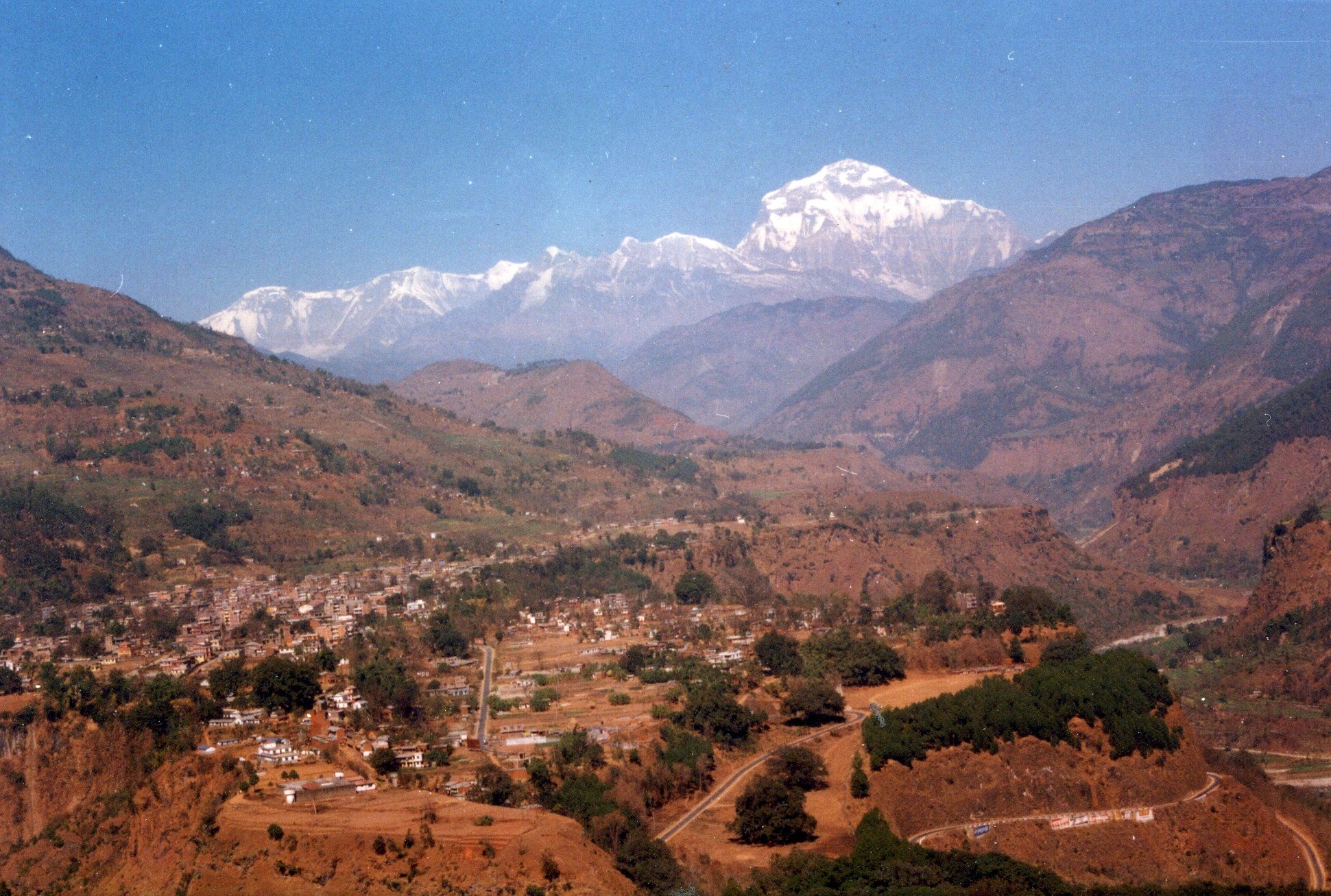
imagesize =300px
image_caption = Baglung Bazar with views of Mt. Dhaulagiri
flag_size =
image_
seal_size =
image_shield =
shield_size =
image_blank_emblem =
blank_emblem_type =
blank_emblem_size =
mapsize =
map_caption =
mapsize1 =
map_caption1 =
image_dot_
dot_mapsize =
dot_map_caption =
dot_x = |dot_y =
pushpin_
pushpin_label_position =bottom
pushpin_map_caption =Location in Nepal
subdivision_type = Country
subdivision_name =
subdivision_type1 = Admin. division
subdivision_name1 =Dhawalagiri Zone
subdivision_type2 = District
subdivision_name2 =Baglung District
subdivision_type3 =
subdivision_name3 =
subdivision_type4 =
subdivision_name4 =
government_footnotes =
government_type =
leader_title =Mayor
leader_name =
leader_title1 =
leader_name1 =
leader_title2 =
leader_name2 =
leader_title3 =
leader_name3 =
leader_title4 =
leader_name4 =
established_title =
established_date =
established_title2 =
established_date2 =
established_title3 =
established_date3 =
area_magnitude =
unit_pref =Imperial
area_footnotes =
area_total_km2 =
area_land_km2 =
area_water_km2 =
area_total_sq_mi =
area_land_sq_mi =
area_water_sq_mi =
area_water_percent =
area_urban_km2 =
area_urban_sq_mi =
area_metro_km2 =
area_metro_sq_mi =
area_blank1_title =
area_blank1_km2 =
area_blank1_sq_mi =
population_as_of =
population_footnotes =
population_note =
population_total =
population_density_km2 =
population_density_sq_mi =
population_metro =
population_density_metro_km2 =
population_density_metro_sq_mi =
population_urban =
population_density_urban_km2 =
population_density_urban_sq_mi =
population_blank1_title =Ethnicities
population_blank1 =
population_blank2_title =Religions
population_blank2 =
population_density_blank1_km2 =
population_density_blank1_sq_mi =
timezone =
utc_offset =
timezone_DST =
utc_offset_DST =
latd=28 |latm=16 |lats= |latNS=N
longd=83 |longm=36 |longs= |longEW=E
elevation_footnotes =
elevation_m = 1020
elevation_ft =
postal_code_type =
postal_code =
area_code =
blank_name =
blank_info =
blank1_name =
blank1_info =
website = www.ddcbaglung.gov.np
footnotes =Baglung (28.27 N, 83.60 E, elev. 1020 m.) lies in the midhills of
Nepal , 275 km west ofKathmandu . Baglung is the district headquarters ofBaglung District and is also the zonal headquarters ofDhawalagiri Zone .Geography
The town also known as
Baglung Bazar is situated on aplateau overlooking theKali Gandaki valley. It has been a quaint trading town since ancient times frequented by traders from north and south. More recently, it is visited by tourists seeking to trek toAnnapurna ,Dhaulagiri ,Dhorpatan andDolpo . Baglung is connected toBeni Bazar ofMyagdi to the north andKusma Bazar ofParbat which are located 13 km to the north and 12 km to the south, respectively. A well-paved but windinghighway connects the town withPokhara , 72 km to the east. Highways to connectJomsom , Mustang,Tibet to the north,Rukum via Burtibang and Dhorpatan to the west and Sera Bazar via airport (probably will see an extension to Palpa) to the south are under construction.Baglung airport, now defunct, is located 12 km to the south of the town. This was the only connection to the outside world before completion of the highway. Above the airport is the village of Rokas (rokapala/rokathar) and on the mountain lies the famous shrine of Lord Bhairav. The latter is a long walk up the mountain through Paiyunpata (where the High school is located) taking 4-5 hours. Once at the top one has a breathtaking view of the surrounding Himalayas and Kusma Bazaar. Baglung has experienced a rapid expansion after the completion of Pokhara-Baglung Highway in the mid-90s. There is now a summer road that connects Baglung to Chaura—where the airport is located.
History
History of Baglung can be traced back to early 16th century. King Pratapi Nayayan of Galkot married the princess of Palpa. The king brought goddess
kali along with him as dowry. Legend follows, nobody was able to carry the sword of Kali. A youth from Kunwar chhetri family was finally able to carry the sword. He was given the honorary title ofKhadka ('khadga' meaning the sword). One night when the wedding procession reached where Baglung is today, the king had a dream. In his dream goddess Kali said she liked the place and wished to stay there. The king then built a temple in honor of goddess Kali and designated the Khadka as caretaker. This was in 1590 B.S. (1533 A.D.). Significant population of Khadka Chhetris can be found in Baglung till date. The strategic location of Baglung soon helped it to grow into a trading town. King Pratapi Narayan also started the tradition of holding an annual fair during 'Chaitre Dashain'. The fair is still held annually and draws thousands of visitors every year during the two day event.Baglung remained to stay a major trading point in Parvat kingdom, where merchants from south came to trade for salt brought by Traders from Tibet. Major trade was carried along theKali Gandaki valley between India and Tibet by Thakali people. Newar merchants migrated to Baglung from Bhaktapur in 18th century. Baglung became part ofGreater Nepal (बिशाल नेपालBishal Nepal ) under unification war led by King Prithvi Narayan Shah. Under unified Nepal, several government offices were established and the town was designated as administrative headquarters of the region. Since then it has remained the most important political and economic town in the Dhaulagiri Zone.Demographics
There are around 25,000 inhabitants (
2005 ) inBaglung Bazar . The district itself has a population of 268,937 (as per statistics of Nepal Government, 2001). Nepali (with accent unique to the region) is the most widely spoken language of the region. Other languages spoken include Newari, Gurung, Thakali, Tibetan and Magar.Baglung is a multicultural and multiracial community. Majority of the population belongs to ethnic communities of
Chhettri ,Magar and Dalits. Smaller groups ofChantyal ,Newar ,Brahmin ,Gurung andThakali also live in the area. Majority of people from Baglung practiceHinduism . Other religions practiced in the area includeBuddhism andIslam .There is a
Tibet anrefugee camp located atDhorpatan .Places of interest
Very good views of
Himalayas can be had from Baglung. Terraced fields, waterfalls, forests, deep gorges and caves are abundant throughout the area. The temples in and around Baglung make an excellent pilgrimage. Baglung Kalika temple (built by King Pratapi Narayan, and renovated in late 90s) is visited by thousands of pilgrims each year especially during the festivals ofDashain andChaitre Dashain . Trekking, biking, and rafting make it an ideal location for thrill seekers. Baglung is also the vantage point for trekkers to Mustang,Dolpa and Mt. Dhaulagiri. Baglung has the only hunting reserve in Nepal.Dhorpatan Hunting Reserve is a prime habitat for blue sheep andsnow leopard .References
External links
* [http://www.ddcbaglung.gov.np District Development Committee of Baglung District]

Wikimedia Foundation. 2010.