- North Miami, Florida
-
City of North Miami, Florida — City — City Hall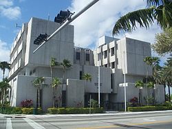
SealNickname(s): NoMi Motto: City of Progress Location in Miami-Dade County and the state of Florida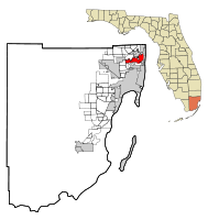 U.S. Census Bureau map showing city limits
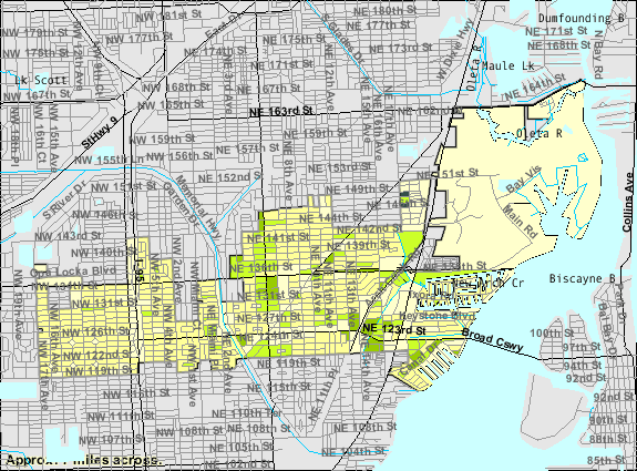
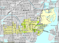
Coordinates: 25°53′42.08″N 80°11′8.69″W / 25.8950222°N 80.1857472°WCoordinates: 25°53′42.08″N 80°11′8.69″W / 25.8950222°N 80.1857472°W Country  United States
State  Florida
County  Miami-Dade
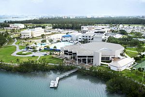
Settled 1890 Incorporated (town) February 5, 1926 Incorporated (city) May 27, 1953 Government - Type Council-Manager - Mayor Andre Pierre - City Manager Russell Benford - City Clerk Alix Desulme - City Council Michael R. Blynn, Jean R. Marcellus, Scott Galvin, Marie Erlande Steril Area - City 10.0 sq mi (25.9 km2) - Land 8.5 sq mi (21.9 km2) - Water 1.5 sq mi (4.0 km2) 15.32% Elevation 7 ft (3.96 m) Population (2007) - City 56,185 - Density 7,080.0/sq mi (2,732.8/km2) - Metro 5,422,200 Time zone EST (UTC-5) - Summer (DST) EDT (UTC-4) Zip Codes 33161, 33162, 33167, 33168, 33169, 33181, 33261 Area code(s) 305, 786 FIPS code 12-49450[1] GNIS feature ID 0287837[2] Website http://www.northmiamifl.gov/ North Miami is a suburban city located in northeast Miami-Dade County, Florida, United States, about 10 miles (16 km) north of Miami. The city lies on Biscayne Bay and hosts the Biscayne Bay Campus of Florida International University, and the North Miami campus of Johnson & Wales University. Originally the town of "Arch Creek", the area was incorporated as the "Town of Miami Shores", which was renamed the "Town of North Miami" in 1931. Then in 1953, the town was renamed the "City of North Miami."
The city is also home to the Oleta River State Park, which is the state's largest urban park.[3]
As of 2007, the population recorded by the U.S. Census Bureau is 56,185.[4] With almost 60,000 residents, North Miami is the fourth largest City in Miami-Dade County.[5]
Contents
History
Early history
In the final phase of Indian inhabitation of the area that eventually became "North Miami", United States Army soldiers in 1856 cut a Military Trail through nearly impassable thickets and rivers connecting Fort Lauderdale to Fort Dallas at the mouth of the Miami River. This eight foot trail, Dade County’s first roadway, crossed a unique natural bridge -- a natural limestone bridge spanning 40 feet (12 m) across the creek that no longer stands in Arch Creek Memorial Park -- in an area that would attract a settlement that early on would be known as "Arch Creek". Even before 1890 a handful of adventuresome pioneers spent brief periods around the Arch Creek Natural Bridge, a centuries-old Indian settlement.
In 1891, a Mr. Ilhe was the first to put down roots in the Arch Creek vicinity. He purchased 80 acres (320,000 m2) from the State of Florida at one dollar an acre in the area of today’s N.E. 116th Street and Biscayne Boulevard. The place was so remote that his nearest northern neighbor was thought to live in Ft. Lauderdale. Mr. Ihle built a temporary palmetto frond shelter. During the next 27 years he grew shallots, coontie, squashes, bananas, sugar cane, Puerto Rican pineapples, lemons, guavas, limes, rose apples, Jamaican apples, and tomatoes.
By 1905 the area surrounding the nine year old Arch Creek Railroad Depot had become the community’s hub. It was located at 125th Street and the F.E.C. tracks. That year a post office and a school were opened nearby. By 1912, eighteen homes, a church, a general store, a blacksmith shop, and two tomato packing houses were located around the railroad. The population was estimated at less than one hundred. Farming was still the principal occupation.
The Florida land boom that was underway in the 1920s spread to Arch Creek farming community. The Biscayne Canal was dug in 1924 to remove farmland from flooded conditions. But as a consequence, the soil began to lose its moisture, and the farming which had been the backbone of the economy, was no longer profitable. However, in step with the times, this drained land became available for partitioning , lot sales, and development.
Birth of North Miami
Thirty eight out of the forty seven registered voters, at the encouragement of developers E.C. Harner, Earl Irons and Arthur Griffing, showed up and voted to incorporate into a town on February 5, 1926. North Miami, between 1926 and 1931, was named "Town of Miami Shores", partially because its early eastern boundary was the Atlantic Ocean. The Town limits were: bounded on the South by Miami and Miami Beach, on the East by the Atlantic Ocean, on the West by 17th Avenue, and on the North by a line which approximates Golden Glades Drive or 166th Street. Incorporation moved costs from developers to residents and lot purchasers. Late in 1926 a bond issue of $287,000 was passed to build streets, sidewalks, a town hall, a water system, and fire protection.
The devastating September 1926 hurricane burst the real estate land speculation. The local community recovered from the damage, but lot sales came to a stop, and the northern tourists names showed up in great numbers on the delinquent tax list. Some money from the bond issue was used to build a Spanish-Mediterranean style city hall building at N.E. 8th Avenue and 125th Street in 1928. The City Hall also housed the police and fire departments. In the 1930s a new water plant and gravity tank was installed behind City Hall. The first newspaper, The Miami Shores Bulletin, was published in 1927-28 and chronicled the events of the times. The historic William Jennings Bryan school was constructed in 1928 on the same spot where the Arch Creek Elementary School had burned down the year before.[6]
The 1930s
Seven miles (11 km) of Atlantic Oceanfront beachland property from the Broward County line southward to Surfside were removed from the town limits as a result of a 1931 Florida Supreme Court decision. The 1926 hurricane ended plans for a causeway to deliver municipal services to that area of town. With no services being received, the beach area instituted a lengthy court lawsuit to separate and form their own community.
The wealthy Shoreland Company, located to the south of the Town, lobbied the 1931 Florida Legislature to officially grant their huge development the name "Village of Miami Shores". The Legislature did so. It also passed an official act abolishing "Town of Miami Shores" as a name. The next step was for the local population to choose a new name. The municipality was renamed The Town of North Miami.
During the Depression years, in 1933, Mrs. Cecille Sevier and Mrs. Ella S. Klefeker became the first two women elected to the Town Council. The 1940s census stated that 1,973 inhabitants lived in the "Town of North Miami".
Post World War II growth
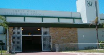
At the end of World War II in 1945, the large and constant influx of former military veterans and their young families changed the face of North Miami by ushering in a great growth period. Homebuilding, road building, shops, stores, and office business construction now continued for decades almost without stopping. By 1951 it was reported nationally that North Miami was one of the fastest growing towns in the United States. During this time, the growing community needed a high school, so in 1951 construction started for North Miami High School. In August 1954, North Miami High School opened its doors for the children of the growing community.
Partially to meet this challenge of fast growth, the voters of North Miami in 1952 voted to adopt a new charter and a new name. The new charter, enacted as an official statute of the Florida Legislature on May 27, 1953 provided for the establishment of a full-time administrative head (City Manager form of government) to carry out the policies of the elected Mayor/Council. The new and present name officially introduced on this date - the City of North Miami.[7]
North Miami is known for its large Haitian-American population. In 2001, voters made Republican Josaphat Celestin the first Haitian American mayor of a large Miami-Dade County community.
Geography
North Miami is located at 25°53′42″N 80°11′09″W / 25.895022°N 80.185747°W.[8]
According to the United States Census Bureau, the city has a total area of 10.0 square miles (26 km2). 8.5 square miles (22 km2) of it is land and 1.5 square miles (3.9 km2) of it (15.32%) is water.
Climate
North Miami has a tropical monsoon climate (Köppen climate classification Am).
Climate data for North Miami Month Jan Feb Mar Apr May Jun Jul Aug Sep Oct Nov Dec Year Average high °F (°C) 78
(26)78
(26)81
(27)84
(29)88
(31)90
(32)92
(33)92
(33)91
(33)87
(31)83
(28)79
(26)85 Average low °F (°C) 62
(17)64
(18)68
(20)70
(21)74
(23)79
(26)78
(26)78
(26)78
(26)74
(23)70
(21)65
(18)72 Precipitation inches (mm) 2.34
(59.4)2.22
(56.4)3.20
(81.3)3.90
(99.1)6.08
(154.4)10.24
(260.1)7.00
(177.8)9.20
(233.7)8.88
(225.6)6.56
(166.6)3.83
(97.3)2.59
(65.8)66.04
(1,677.4)Source: [9] Surrounding areas
- Golden Glades, North Miami Beach
- Opa-locka


 Sunny Isles Beach
 - Westview

 Sunny Isles Beach, Biscayne Bay, Bay Harbor Islands
 - Westview


 Biscayne Bay
 - Pinewood, Unincorporated Miami-Dade County, Biscayne Park
Demographics
As of the census of 2000, there are 59,880 people, 20,541 households, and 13,577 families residing in the city. The population density is 7,080.0 inhabitants per square mile (2,732.8/km2). There are 22,281 housing units at an average density of 2,634.4 per square mile (1,016.9/km2). The racial makeup of the city is 34.81% White (18.1% were Non-Hispanic White,)[10] 54.89% African American or Black (with a large majority being of Caribbean ancestry,) 0.32% Native American, 1.92% Asian, 0.05% Pacific Islander, 3.16% from other races, and 4.85% from two or more races. 23.16% of the population are Hispanic or Latino of any race.
There were 20,541 households out of which 37.6% had children under the age of 18 living with them, 39.0% were married couples living together, 20.1% had a female householder with no husband present, and 33.9% were non-families. 26.9% of all households were made up of individuals and 6.8% had someone living alone who was 65 years of age or older. The average household size was 2.85 and the average family size was 3.51.
In the city the population was spread out with 28.1% under the age of 18, 11.3% from 18 to 24, 31.8% from 25 to 44, 19.6% from 45 to 64, and 9.2% who were 65 years of age or older. The median age was 32 years. For every 100 females there were 92.7 males. For every 100 females age 18 and over, there were 89.0 males.
The median income for a household in the city was $29,778, and the median income for a family was $31,760. Males had a median income of $25,388 versus $20,712 for females. The per capita income for the city was $14,581. About 20.7% of families and 23.9% of the population were below the poverty line, including 29.5% of those under age 18 and 17.2% of those age 65 or over.
As of 2000, residents who spoke English as a mother tongue were 35.49% of the population, while French Creole made up 33.28%, Spanish was at 24.88%, and French accounted for 2.69% of the population.[11]
As of 2000, North Miami had the second highest percentage of Haitian residents in the US, with 33% of the US populace (the first highest concentration, at 33.5% of the US population, was Golden Glades.)[12] It had the seventy-first highest percentage of Cuban residents in the US, at 4.43% of the city's population,[13] and the ninety-first highest percentage of Dominican residents in the US, at 1.72% of the city's population (tied with Golden Glades and East Newark, New Jersey.)[14] It also had the sixth most Bahamians in the US, at 1.2% of all residents (tied with West Little River.)[15] North Miami's Jamaican community had the fortieth highest percentage, at 3.3% of the population (tied with Plainfield, New Jersey.)[16]
Government
North Miami is governed using the council-manager system. The mayor and the City Clerk are elected at large. There are four districts each electing one member of the council. The council has authority over the manager.[17][18]
Transportation
In December 2004, the City of North Miami implemented a free community bus service called the NoMi Express, in order to increase the number of local destinations that can be reached through public transit. Since its inauguration in December, 2004, the NoMi Express averages approximately 750 boardings per day, which translates to 16,000 boardings per month or 190,000 boardings annually.[19]
Attractions
Museums
- The Museum of Contemporary Art (MOCA) is a museum located in the heart of downtown North Miami, Florida. The 23,000-square-foot (2,100 m2) structure was designed by the internationally acclaimed architect Charles Gwathmey of Gwathmey Siegel, New York, who worked in conjunction with the Miami firm of Gelabert-Navia to create the building.
State parks
- The Oleta River State Park is the largest urban park in the Florida State Park system. The park is located on 1,043 acres (4.22 km2) - 993 acres (4.02 km2) of land and 50 acres (0.20 km2) of inland water - on Biscayne Bay, in the northeastern end of the city of North Miami in Miami-Dade County, Florida, and adjoins the Biscayne Bay Campus of Florida International University. In some documents, the park is designated as the Oleta River State Recreation Area. The park contains one of the largest concentrations of Australian Pine trees (an invasive species) found in a Florida State Park.
- The Arch Creek Park was formally dedicated on April 25, 1982. Today, Arch Creek is an 8-acre (32,000 m2) site at the junction of N.E. 135th Street and Biscayne Boulevard in North Miami, Fla., and offers many opportunities for botanical, historical and archaeological study. It has a museum/nature center modeled after an early Florida pioneer home, displaying Indian artifacts dug from the grounds, and live animals from the nearby hammock. Remains of the original coontie mill are still visible across the creek, and the Park exists as the only preserved archaeological site in the County.
Biscayne Landing
Biscayne Landing is a mixed use commercial/hotel/residential community being developed on the site of the Munisport Landfill Superfund Site.[20] The City of North Miami will retain ownership of this Brownfield site and the developers, Boca Developers, will retain a 200 year lease for the development of the project.
The master-planned development will feature approximately 120,000 square feet (11,000 m2) of commercial office and retail space, 2,800 to 5,000 residential units, a park and recreation facilities. As part of the development agreement for the site, the project’s developer has also committed to renovating the city’s library and building a school, Olympic training facility, and affordable housing on several sites located in North Miami. Completion of all elements of the project are projected by 2021.
A portion of the Biscayne Landing site includes some of the wetlands of Biscayne Bay, which will be preserved in the form of a 35-acre (140,000 m2) environmental park, containing nature hikes, jogging paths, information plaques that describe the resident wildlife and trees, benches, a canoe landing and a boat house. It will also have connecting trails to Oleta River State Park. This area is the site of a former trash dump and is the home to a large sewage treatment plant nearby.
In 2009, Biscayne Landing is reeling in the real estate downturn. Most of the units in the two buildings online so far are uninhabited; very few are selling. There is little actual construction on any other project related to their contractual obligations under a redevelopment agreement with the City of North Miami.
A group of North Miami voters, enraged over the millions of taxpayer dollars awarded Biscayne Landings' developers, founded www.ChangeNorthMiami.com to assure the June 2, 2009 mayoral election is a vote of no confidence for the failed development and affiliated affordable housing plans, also stalled.
Education
Primary and secondary schools
Miami-Dade County Public Schools serves North Miami.
Elementary schools
- Benjamin Franklin Elementary School
- Biscayne Gardens Elementary School
- Gratigny Elementary
- North Miami Elementary School
- Natural Bridge Elementary School
- W. J. Bryan Elementary School
Middle schools
- Thomas Jefferson Middle School
- North Miami Middle School
K-8 centers
High schools
- Alonzo and Tracy Mourning Senior High Biscayne Bay Campus
- North Miami Senior High School
Private schools
- Northwest Christian Academy
- Holy Cross Lutheran School
- Yeshiva Toras Chaim
- Miami Union Academy SDA
- Montessori School of North Miami
Colleges and universities
Public libraries
The North Miami Public Library is the city's library.[21]
See also
- Arch Creek
- Biscayne Landing
- Miami-Dade County, Florida
- Munisport Landfill
- Museum of Contemporary Art, North Miami
- North Miami High School
- North Miami Middle School
- Oleta River State Park
References
- ^ "American FactFinder". United States Census Bureau. http://factfinder.census.gov. Retrieved 2008-01-31.
- ^ "US Board on Geographic Names". United States Geological Survey. 2007-10-25. http://geonames.usgs.gov. Retrieved 2008-01-31.
- ^ Florida State Parks Guide
- ^ http://www.census.gov/popest/cities/tables/SUB-EST2005-04-12.xls
- ^ North Miami Transit Circulator Study, Executive Summary
- ^ City of North Miami official site - History Page 1
- ^ City of North Miami official site - History Page 2
- ^ "US Gazetteer files: 2010, 2000, and 1990". United States Census Bureau. 2011-02-12. http://www.census.gov/geo/www/gazetteer/gazette.html. Retrieved 2011-04-23.
- ^ "Average weather for North Miami". Weather.com. http://www.weather.com/outlook/travel/businesstraveler/wxclimatology/monthly/graph/USFL0566?from=36hr_bottomnav_business. Retrieved 13 August 2009.
- ^ "Demographics of North Miami, FL". MuniNetGuide.com. http://www.muninetguide.com/states/florida/municipality/North_Miami.php. Retrieved 2007-10-28.
- ^ "MLA Data Center Results of North Miami, FL". Modern Language Association. http://www.mla.org/map_data_results&state_id=12&county_id=&mode=&zip=&place_id=49450&cty_id=&ll=&a=&ea=&order=r. Retrieved 2007-10-28.
- ^ "Ancestry Map of Haitian Communities". Epodunk.com. http://www.epodunk.com/ancestry/Haitian.html. Retrieved 2007-10-28.
- ^ "Ancestry Map of Cuban Communities". Epodunk.com. http://www.epodunk.com/ancestry/Cuban.html. Retrieved 2007-10-28.
- ^ "Ancestry Map of Dominican Communities". Epodunk.com. http://www.epodunk.com/ancestry/Dominican-Republic.html. Retrieved 2007-10-28.
- ^ "Ancestry Map of Bahamian Communities". Epodunk.com. http://www.epodunk.com/ancestry/Bahamian.html. Retrieved 2007-10-28.
- ^ "Ancestry Map of Jamaican Communities". Epodunk.com. http://www.epodunk.com/ancestry/Jamaican.html. Retrieved 2007-10-30.
- ^ "Precinct Boundary Map." City of North Miami. Retrieved on March 12, 2010.
- ^ "Official Zoning Map." City of North Miami Beach. Retrieved on March 12, 2010.
- ^ Miami-Dade CITT Insider
- ^ US Environmental Protection Agency - Sites in Reuse, Munisport
- ^ "Welcome to North Miami Public Library." City of North Miami. Retrieved on March 12, 2010.
External links
- City of North Miami
- City of North Miami History
- North Miami Police Department
- North Miami Community Redevelopment Agency
South Florida metropolitan area Largest city Counties
(by population)Cities and towns
100k-250kCities and towns
25k-99kAventura • Boca Raton • Boynton Beach • Coconut Creek • Cooper City • Coral Gables • Dania Beach • Davie • Deerfield Beach • Delray Beach • Doral • Greenacres • Hallandale Beach • Homestead • Jupiter • Lake Worth • Lauderdale Lakes • Lauderhill • Margate • Miami Beach • North Lauderdale • North Miami • North Miami Beach • Oakland Park • Palm Beach Gardens • Plantation • Riviera Beach • Sunrise • Tamarac • West Park • Weston • Wilton ManorsCities and towns
10k-25kA list of cities under 10,000 is available here.  State of Florida
Tallahassee (capital) Topics Delegations · Environment · Floridians · Geography · Government · History · State Parks · Transportation · Visitor Attractions
Society Culture · Crime · Demographics · Economy · Education · Politics
Regions Big Bend · Central Florida · Emerald Coast · First Coast · Florida Heartland · Florida Keys · Florida Panhandle · Forgotten Coast · Fun Coast · Gold Coast · Nature Coast · North Central Florida · North Florida · South Florida · Southwest Florida · Space Coast · Sun Coast · Tampa Bay Area · Treasure Coast
Metro areas Miami–Fort Lauderdale–Pompano Beach (Miami-Dade, Broward, Palm Beach) · Tampa-St. Petersburg-Clearwater (Hernando, Hillsborough, Pasco, Pinellas) · Orlando-Kissimmee-Sanford (Lake, Orange, Osceola, Seminole) · Jacksonville (Duval, Clay, St. Johns, Nassau, Baker) · North Port–Bradenton–Sarasota (Manatee, Sarasota) · Cape Coral-Fort Myers (Lee) · Lakeland-Winter Haven (Polk) · Palm Bay-Melbourne-Titusville (Brevard) · Deltona-Daytona Beach-Ormond Beach (Volusia) · Pensacola-Ferry Pass-Brent (Escambia, Santa Rosa) · Port St. Lucie (St. Lucie, Martin) · Tallahassee (Gadsden, Jefferson, Leon, Wakulla) · Ocala (Marion) · Naples-Marco Island (Collier) · Gainesville (Alachua, Gilchrist) · Fort Walton Beach-Crestview-Destin (Okaloosa) · Panama City-Lynn Haven-Panama City Beach (Bay) · Punta Gorda (Charlotte) · Sebastian-Vero Beach (Indian River) · Palm Coast (Flagler)
Largest cities Jacksonville · Miami · Tampa · St. Petersburg · Orlando · Hialeah · Tallahassee · Fort Lauderdale · Port St. Lucie · Cape Coral · Pembroke Pines · Hollywood · Coral Springs · Gainesville · Miramar · Clearwater · Pompano Beach · Palm Bay · West Palm Beach · Miami Gardens · Lakeland · Davie · Sunrise · Boca Raton · Miami Beach
Counties Alachua · Baker · Bay · Bradford · Brevard · Broward · Calhoun · Charlotte · Citrus · Clay · Collier · Columbia · DeSoto · Dixie · Duval · Escambia · Flagler · Franklin · Gadsden · Gilchrist · Glades · Gulf · Hamilton · Hardee · Hendry · Hernando · Highlands · Hillsborough · Holmes · Indian River · Jackson · Jefferson · Lafayette · Lake · Lee · Leon · Levy · Liberty · Madison · Manatee · Marion · Martin · Miami‑Dade · Monroe · Nassau · Okaloosa · Okeechobee · Orange · Osceola · Palm Beach · Pasco · Pinellas · Polk · Putnam · Santa Rosa · Sarasota · Seminole · St. Johns · St. Lucie · Sumter · Suwannee · Taylor · Union · Volusia · Wakulla · Walton · Washington
Categories:- North Miami, Florida
- Cities in Miami-Dade County, Florida
- Populated coastal places in Florida
- Populated places established in 1926
- Populated places in Florida with African American majority populations


Wikimedia Foundation. 2010.