- Miami River (Florida)
-
Miami River 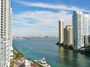
The mouth of the Miami River at Brickell Key
(February 2010).Origin The Everglades Mouth Brickell Point Basin countries United States Length 5.5 mi (8.9 km) Source elevation Sea level Avg. discharge 50 ft³/s (15 m³/s) Basin area 2,800 sq mi (7,300 km2) The Miami River is a river in the United States state of Florida that drains out of the Everglades and runs through the Downtown and the city of Miami. The 5.5-mile (8.9 km) long river flows from the terminus of the Miami Canal at Miami International Airport to Biscayne Bay. It was originally a natural river inhabited at its mouth by the Tequesta Indians, but it was dredged and is now polluted because of its route through Miami-Dade County. The mouth of the river is now home to the Port of Miami and many other businesses whose pressure to maintain it has helped to improve the river's condition.
Contents
Etymology
Although it is widely believed that the name is derived from a Native American word that means "sweet water", the earliest mention of the name comes from Hernando de Escalante Fontaneda, a captive of Indians in southern Florida for 17 years, when he referred to what is now Lake Okeechobee as the "Lake of Mayaimi, which is called Mayaimi because it is very large".[1] Spanish records include the cacique of 'Maimi' in a group of 280 Florida Indians that arrived in Cuba in 1710.[2] Reports on a Spanish Mission to the Biscayne Bay area in 1743 mention 'Maymies' or 'Maimíes' living nearby.[3] The river has also been known as the Garband River, Rio Ratones, Fresh Water River, Sweetwater River, and Lemon River. It has been known as the Miami River since the Second Seminole War of 1835–42.[4]
Natural river
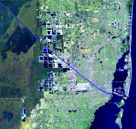
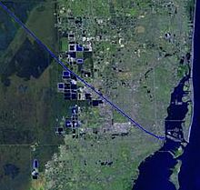 Map of Miami, Florida with the river in blue
In its original natural state, the river started at rapids formed by water from the Everglades flowing over a rocky ledge four miles (6.4 km) from its mouth. Frederick H. Gerdes of the U.S. Coast Survey reported in 1849 that "[f]rom the upper falls to near its entrance into Key Biscayne Bay… water in the Glades was 6 feet 2.5 inches (1.89 m) above low tide."[5] The rapids were removed when the Miami Canal was dredged in an attempt to drain the wetland.
The river divided into a North Fork and a South Fork about three miles (4.8 km) above its mouth. Each fork extended only one mile (1.6 km) to rapids marking the edge of the Everglades. The North Fork had the greater flow and the higher drop over its rapids. One-and-one-half miles (2.4 km) above the mouth of the river there was a tributary on the north side, called Wagner Creek, which was about two miles (3.2 km) long. The Miami River was also fed by several springs, including some in the bed of the river. Flow was variable and in times of drought sometimes stopped completely.[6]
History
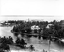 The mouth of the Miami River at Brickell Point
(August 1935).The earliest known inhabitants of the area around the Miami River were the Tequestas. Their major town at the time of first European contact was on the north bank of the river near the mouth. Before the intensive development of Miami in the 20th century, mounds built by the Tequesta were located along the river.[7] Spanish missions were briefly established beside the river in 1567–70 and in 1743, but the area was abandoned when Spain turned Florida over to Britain in 1765.[8]
The area around the Miami River attracted settlers throughout the 19th century, with the major exception of the years of the Seminole Wars, but had little effect on the river. The US Army tried to dig a channel through the sandbar at the mouth of the river in 1856 but stopped when it was decided that Fort Dallas would not be made permanent.[9]
Dredging and pollution
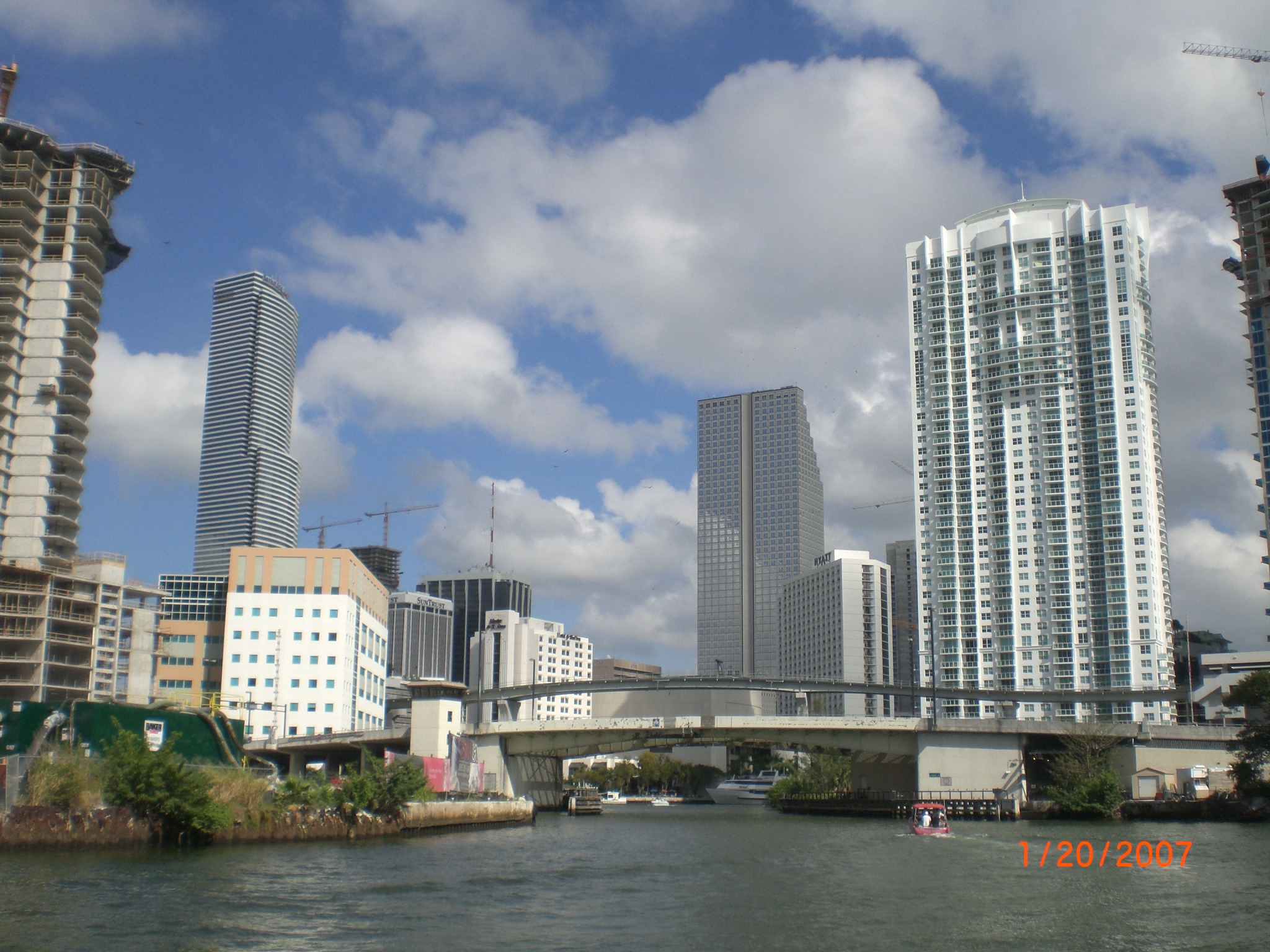
 The Miami River in 2007
Modification of the river began in earnest with the arrival of the Florida East Coast Railway in Miami in 1896. There was much dredging and filling along the river. The rapids at the head of the South Fork were removed in 1908. From 1909 to 1912, the Miami Canal was dug, bypassing the rapids at the head of the North Fork. The canal was dammed off from the river for most of the construction period. When the canal was opened to the river in March 1912 large amounts of Everglades muck and finely ground stone from the dredging were washed down the river, silting it. As a result, the lower river had to be dredged three times in two years.[10]
Dredging of the river and of canals connecting to the river continued into the 1930s. Deepening the Miami River (and other streams and canals draining into Biscayne Bay), as well as the drainage of the Everglades that was a major purpose of the dredging, led to saltwater intrusion in the area, forcing the abandonment of drinking water wells on several occasions. By the 1940s, dams were being installed on the canals leading into the Miami River to prevent salt water from traveling inland.[11]
The Miami River also became polluted. In 1897, Miami's first sewer line started emptying directly into the river. By the 1950s, 29 sewers were dumping untreated sewage into the river. Dade County constructed a sewage treatment plant on Virginia Key in the 1950s and started connecting sewer lines to it, a project that took many years.[12]
Commercial use
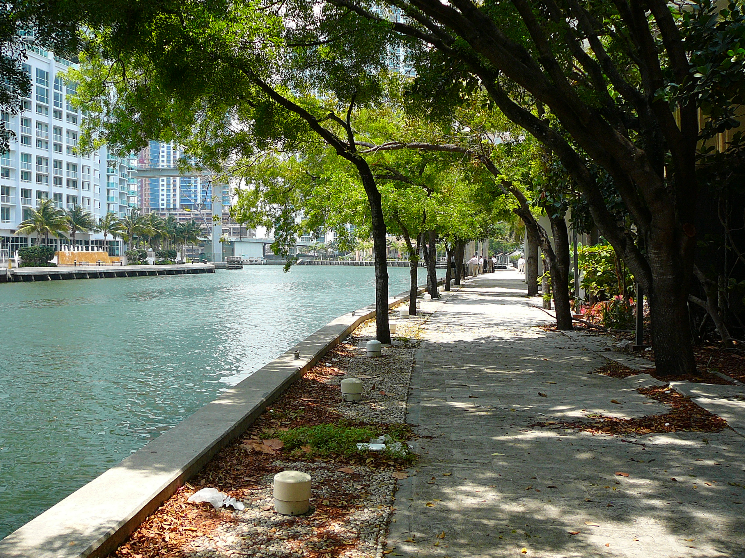
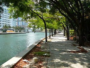 The new Miami Riverwalk as of May 2008, where pedestrians can walk along the river, dine at various cafes and shop at various boutiques
The Miami River has long been home to many small cargo terminals at which smaller ships (up to about 230 feet (70 m) in length) call to load cargo, most of which is destined for ports in the Bahamas and various Caribbean nations. It is also an area into which all manner of contraband—illegal drugs, illegal aliens—has been discharged into the US. Because of continuing efforts by the United States Coast Guard, U.S. Bureau of Immigration and Customs Enforcement (ICE), DEA and other agencies, the illicit trade has been minimized in recent years.
Although the part of the river from Northwest 36th Street to its mouth is still polluted, this has been mitigated considerably by rigid enforcement of both international and US laws regarding discharge of oil and sewage by ships as well as of laws addressing industrial dumping. The muddy bottom, however, is still reported to contain undesirable substances in significant quantities.
In years past, many vessels docked in the river at the ends of their last voyages were abandoned and sank alongside the docks, creating eyesores and hazards to navigation. Those derelicts have been removed.
Invoking the authority of Port State Control, the US Coast Guard now vigorously enforces the many international and national regulations regarding safety equipment, construction, maintenance, and manning of ships entering all US ports including the Miami River, virtually eliminating the many dangerously substandard vessels that had sailed from the US in previous years.
In recent years, realizing they had common interests, various business entities along the river formed the Miami River Group. The group works closely with local law enforcement agencies, the US Coast Guard, ICE, and others to maintain clear channels of communication and cooperation. It now acts much as one port with numerous port facilities and support entities such as agents, surveyors, consultants, naval architects and engineers, and ship and machinery repair businesses.
Many of the ships sailing from the Miami River carry much needed cargo to ports in Haiti including Port-au-Prince, Miragoâne, Cap-Haïtien, Port-de-Paix, Saint-Marc, Gonaïves, and Jacmel. Their cargo typically consist of dry foodstuffs such as beans and rice, canned goods, clothing, household goods and appliances, and used cars, trucks, and buses.
In times past, some of the cargo terminals on the river were areas of lawlessness. Law enforcement and regulatory agencies have eliminated most of that sort of activity. When the International Ship and Port Security Code and the U.S. Maritime Transportation Act of 2002 came into force (and in the prior runup) on July 1, 2004, most opportunities for crime were eliminated.
Some of the terminals and other business related to cargo shipping on the "lower end" of the river near downtown Miami have been eliminated or moved farther upstream because of illicit shipping activities. The "lower end" of the river has been the subject of much renovation and building of high rise offices, hotels, and living structures.
See also
References
- ^ Milanich 1995, pp. 39–40.
- ^ Sturtevant 1978, pp. 143.
- ^ Sturtevant 1978, pp. 147.
- ^ Gaby 1993, p. 1.
- ^ Blank 1996, pp. 69–70.
- ^ Gaby 1993, pp. 1–3.
- ^ Milanich 1995, pp. 54–53.
- ^ Sturtevant 1978, p. 141
- ^ Gaby 1993, p. 7.
- ^ Gaby 1993, p. 8.
- ^ Gaby 1993, pp. 14–15.
- ^ Gaby 1993, pp. 17–19.
Further reading
- Blank, Joan Gill (1996), Key Biscayne, Sarasota, Florida: Pineapple Press, Inc, ISBN 1-56164-096-4.
- Gaby, Donald C (1993), The Miami River and its Tributaries, Miami: The Historical Association of Southern Florida, ISBN 0-935761-04-7.
- Milanich, Jerald T. (1995), Florida Indians and the Invasion from Europe, Gainesville, Florida: University Press of Florida, ISBN 0-8130-1360-7.
- Sturtevant, William C (1978), "The Last of the South Florida Aborigines", in Milanich, Jeral; Proctor (Eds.), Samuel, Tacachale: Essays on the Indians of Florida and Southeastern Georgia during the Historic Period, Gainesville, Florida: The University Presses of Florida, ISBN 0-8130-0535-3.
External links
- Miami-Dade History
- U.S. Army Corps of Engineers Dredging Page
- Miami River Commission
- Water Quality Report
- City of Miami's Miami River Development Plan
25°46′10″N 80°11′31″W / 25.76944°N 80.19194°WCoordinates: 25°46′10″N 80°11′31″W / 25.76944°N 80.19194°W
Greater Miami CBD Urban centers Major thoroughfares North 36th Street · North 79th Street · North 103rd Street · North 125th Street · West 7th Avenue · West 27th Avenue · West 107th Avenue · Allapattah Road · Alton Road · Bird Road · Biscayne Boulevard · Collins Avenue · Coral Reef Drive · Coral Way · County Line Road · Flagler Street · Galloway Road · Gratigny · Ives Dairy Road · Julia Tuttle Causeway · Kendall Drive · Killian · Krome Avenue · William H. Lehman Causeway · LeJeune Road · Ludlam Road · MacArthur Causeway · Miami Avenue · Miami Gardens Drive · Milam Dairy Road · Miracle Mile · Ocean Drive · Okeechobee Road · Old Cutler Road · Port Boulevard · Red Road · Rickenbacker Causeway · South Dixie Highway · Sunset Drive · Tamiami Trail · Venetian CausewayColleges and universities Parks and recreation Amelia Earhart Park · Arch Creek · The Barnacle Historic State Park · Bayfront Park · Bicentennial Park · Big Cypress National Preserve · Bill Baggs Cape Florida State Park · Biscayne National Park · Chapman Field Park · Crandon Park · Dinner Key · Everglades National Park · Fairchild Tropical Botanic Garden · Fort Dallas · Fruit and Spice Park · Greynolds Park · Haulover Park · The Kampong · Matheson Hammock Park · Oleta River State Park · Peacock Park · Shark Valley · South Pointe Park · Tamiami Park · Tropical Park · Virginia Key · Zoo MiamiMajor districts and attractions Adrienne Arsht Center for the Performing Arts · American Airlines Arena · Boca Chita Key Historic District · Coral Castle · Design District · Downtown Miami Historic District · Jungle Island · Lummus Park · Homestead Historic Downtown District · MacFarlane Homestead District · Miami Art Deco District · Miami Seaquarium · Monkey Jungle · Normandy Isles Historic District · North Shore Historic District · Miami Riverwalk · South Beach · Villa VizcayaMajor shopping centers Aventura Mall · Bal Harbour Shops · Bayside Marketplace · CocoWalk · Dadeland Mall · Dadeland Station · Dolphin Mall · The Falls · Lincoln Road Mall · The Mall at 163rd Street · Mall of the Americas · Mary Brickell Village · Metrofare Shops & Cafe · Miami International Mall · Miracle Marketplace · The Shops at Sunset Place · Southland Mall · Village of Merrick Park · Westland MallPrimary modes of transport Categories:- Landforms of Miami-Dade County, Florida
- Rivers of Florida
- Geography of Miami, Florida


Wikimedia Foundation. 2010.