- Metrorail (Miami)
-
Metrorail 
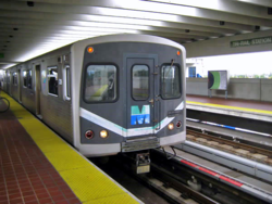
A southbound train entering Tri-Rail station.Info Locale Greater Miami Transit type Rapid transit Number of lines Green Line
Orange Line (under construction)[1]Number of stations 22
23 (2012)Daily ridership 65,300 (2011)
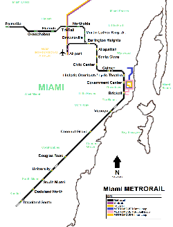
96,000 (2011, including Metromover)[2]Website Metrorail Operation Began operation 20 May 1984 Operator(s) Miami-Dade Transit (MDT) Technical Track gauge 1,435 mm (4 ft 8 1⁄2 in) Standard gauge Top speed 57 mph (92 km/h) System map The Miami Metrorail, officially Metrorail and commonly called the Metro, is the heavy rail rapid transit system of Miami, Florida, United States, serving the Miami metropolitan area. The Metro is operated by Miami-Dade Transit, a departmental agency of Miami-Dade County. Opened in 1984, it is Florida's only rapid transit metro system, and is currently composed of 22.4 miles (36.0 km) line with 22 stations.
The Metro serves the urban core of Miami, connecting the central business districts of Downtown Miami, Brickell and the Civic Center with the Greater Miami neighborhoods of Hialeah and Medley to the northwest, and to Coconut Grove, Coral Gables, South Miami, ending at Dadeland in suburban Kendall. The Metro connects to the Metromover in Downtown, which provides metro service to the entirety of Downtown. The Metro has seen increased ridership growth over the years, with an average daily ridership of 65,300 passengers, as of February 2011[update] (96,000, including Metromover).[3]
In 2012, the Metro will open its 23rd station, Miami Central Station, at Miami International Airport (MIA), opening a 16-station re-branded Orange Line between the MIA and Dadeland South stations. The new line is expected to increase ridership significantly, allowing residents and visitors alike direct access from the MIA to Downtown Miami, and greater connectivity between various modes of transit throughout Miami-Dade County. Central Station will provide direct service to Amtrak inter-city rail services, Tri-Rail commuter rail, Greyhound Lines intercity bus, and the Rental Car Center. Miami Central Station is expected to attract 150,000 daily commuters and travellers.[4]
The Metro is one of only two rapid transit systems in the Southeastern United States (the other system being MARTA in Atlanta).
Contents
History
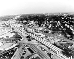 Metrorail viaduct under construction along South Dixie Highway (US 1) in Coral Gables during the early 1980s.
In 1971, a study completed by the Miami Urban Area Transportation Study (MUATS) recommended the construction for a rapid transit system for the county; having experienced a prolonged post-World War II population boom, metropolitan Dade County's permanent population rose by 35% to nearly 1.3 million residents within a decade, among the fastest population growth rates in the United States.[5] Within a year of the study, county residents approved a $132.5 million ($695.6 million, adjusted for current inflation) bond dedicated to transit, with additional funding approved by the Florida Legislature for transit which, up until that time, operated solely on fare revenue. In 1976, with preliminary engineering completed for the system, the Federal Transit Administration (FTA, then, the Urban Mass Transit Administration) committed 80% of the costs for the first stage of rapid transit system, with the county and state incurring the remaining cost.
In April 1979, the Interstate Commerce Commission ratified an agreement between the Florida East Coast Railway (FEC) and Dade County to transfer the then-FEC right-of-way along US 1 to Miami-Dade Transit, then named the Metro Transit Agency (MTA), with groundbreaking for the system the county commission voted to be named "Metrorail" taking place at the site of what would become University Station in June. Construction began in December 1980 with placing of a double-tee guideway girder near the University of Miami. In June 1983, the first segment of Metrorail from Dadeland South to Overtown (now "Historic Overtown/Lyric Theatre") was completed with the construction of the Miami River bridge, with free first-day service from Pinecrest to Overtown commencing May 20, 1984 with over 125,000 riders.
Additional segments opened subsequently in December 1984 between Earlington Heights and Okeechobee stations in May 1985. In March 1989, temporary station was opened to provide a connection to the newly-opened Tri-Rail commuter rail line, with the station officially opening in June of that year. Preliminary engineering for a rapid transit extension to the Palmetto Expressway began in 1996 with Palmetto station opening in May 2003. Revenues expected for 2006 were $17.15 million. Expenses budgeted for 2006 were $41.29 million. These historic figures became the last the Miami Dade Transit Authority ever disclosed, and in fact are the figures still displayed in today's Miami-Dade Transit webpage as of July 2011.[6]
Construction on Metrorail's 23rd station at the Miami Central Station at Miami International Airport began in May 2009, with service projected to begin in late 2011/early 2012.[7][8]
Train and track information
Metrorail Legend


Palmetto 


(SR 826) 


to West Palm Beach or New York 


Okeechobee 


Hialeah 


Tri-Rail (transfer to Tri-Rail) 


Northside 


Hialeah Market (Tri-Rail) 


Dr. Martin Luther King Jr. Plaza 


Brownsville 


Airport (transfer to Amtrak and Tri-Rail; op. 2012) 


(Miami River) 


(SR 112) 


Earlington Heights 


(SR 112/I-195) 


Allapattah 


Santa Clara 


Civic Center 


(I-395) 


Culmer 


(I-95) 


Historic Overtown/Lyric Theatre 


Government Center (transfer to Metromover) 


(Miami River) 


Brickell (transfer to Metromover) 


(I-95) 


Vizcaya 


Coconut Grove 


Douglas Road 


University 


South Miami 


Dadeland North 


(SR 878) 


Dadeland South (transfer to South Miami-Dade Busway)  A Metro train entering University Station
Metrorail runs from the northwest in Medley through Hialeah, into the city of Miami, the downtown area, through Coral Gables and South Miami, and ending in southwest Miami-Dade at Dadeland Mall. There are 22 accessible Metrorail stations, one about every 1.25 miles (or 1.9 kilometers). Metrorail connects to the Metromover system at Government Center and Brickell stations and to South Florida's Tri-Rail suburban system at the Tri-Rail Station (see below).
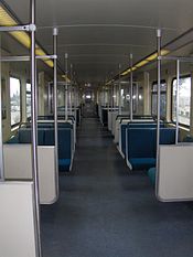
Trains are stored at the Palmetto Yard just west of Okeechobee Station. The yard houses 136 cars built by the Budd Company; Miami-Dade's subway cars were among the last orders Budd filled before shuttering its railcar manufacturing business. The cars are identical to those used on the Baltimore Metro (save for the modifications made to Baltimore's cars during their refurbishment in 2005), as the two systems were built at the same time, and the two agencies were able to save money by sharing a single order.
The cars are operated in 2-car units, and joined up to form 6-car trains, which is the normal train length. For the 10-minute interval peak time service (2011 schedule), 12 such trains are required, the journey takes 50 minutes from end to end, with a 10 minute standing time at each end. Therefore 72 cars are required for the daily service. It will be seen that the 136 cars built for the system were therefore a considerable overprovision. For the 15-minute interval weekday daytime service, 7 trains are required, and 5 trains are thus stored after each rush period. Only four trains are used to provide the weekday evening 30-minute service. All trains are scheduled to run from end to end of the route.
Along the Metrorail system, the tracks are mostly elevated. Three sections are not: under I-95 between Vizcaya and Brickell stations, under I-95 just east of Culmer station, and from just east of the Palmetto Expressway heading west into the Palmetto station and tail track. In each of these cases, the tracks ride on ground level for a brief amount of time.
The platform at each Metrorail station is long enough to accommodate six-car-long trains; the Dadeland North and Government Center station platforms are long enough to accommodate eight-car-long trains. In-service trains are usually either four or six cars long; in the evening it is not uncommon for Miami-Dade Transit to link two out-of-service trains together before returning them to Palmetto Yard.
Fares and service
The current standard fare on Metrorail is $2 and reduced fare is $1. A standard monthly pass costs $100 and $50 for reduced fare. The monthly EASY Cards are sold at over 50 sales outlets. Reduced fares are available only to Medicare recipients, people with disabilities, and Miami-Dade students in grades 1-12. Ticket Vending Machines (TVMs) that sell EASY Cards and EASY Tickets are found in all rail stations. All Miami-Dade senior citizens aged 65 years and older and with Social Security benefits, and Veterans residing in Miami-Dade and earning less than $22,000 annually ride free with the reduced fare monthly EASY Card. All of the stations except the five in the downtown area have dedicated parking available.
On July 16, 2008, Miami-Dade Transit announced that it would be replacing all fare collection methods with the EASY Card system by late 2009. The system replaces the old cash-/token-based system with one that automatically deducts fares at Metrorail fare gates from a reloadable card.[9][10][11] The final station to start fare gate installation was Government Center on August 2, 2009.[12] Since the system launch on October 1, 2009, all passengers utilizing Metrorail must use either an EASY Card or EASY Ticket to enter stations.[13]
Metrorail runs from 5 a.m. until midnight seven days a week. Trains arrive every 8 minutes during weekday rush hours, every 15 minutes at midday, and every 15–30 minutes after 6 p.m. until midnight. Weekend service runs every 30 minutes until midnight. For a brief period from 2003 to April 2004 there was 24-hour service; between midnight and 5 a.m., trains arrived every 60 minutes.
A limited-stop bus route, Route 500 Midnight Owl, operates hourly between 12:30 a.m. and 5:30 a.m. trip between Dadeland South and Government Center Metrorail stations. This bus service replaces the 24-hour Metrorail service cancelled due to a lack of ridership.
Construction on the first segment of the Orange Line, Metrorail's AirportLink[14] began in June 2009; service to Miami International Airport is scheduled to begin in spring 2012.
The Miami-Dade County Government is working with the Citizens Independent Transportation Trust to receive money from the half-penny sur-tax approved by voters in 2002 in order to purchase new Metrorail cars.
Stations
Main article: List of Miami-Dade Transit metro stations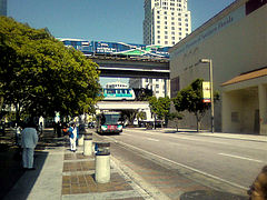 Varying transit modes operating simultaneously at Government Center
 Miami Central Station under construction in June 2011
Metrorail currently operates 22 stations, and combined with the Metromover in Downtown Miami and Brickell, the entire Metro system operates 44 stations. Metrorail stations are located at about a mile apart along the line, and Metromover stations are located at approximately every two blocks in the greater Downtown area.
Current stations
Travel times provided are approximate for travel to and from Government Center in the CBD of Downtown; additional station, passenger, and transfer information available on respective Wikipedia pages:
Number Station Lines Time to Downtown Opened Average weekday ridership
(02/2011)[15]Connections 1 Palmetto 
31 min May 30, 2003 1,169 Metrobus: 87 2 Okeechobee 
26 min May 19, 1985 1,414 Metrobus: 73 3 Hialeah 
23 min May 19, 1985 1,710 Metrobus: 29, 37, 54, L 4 Tri-Rail 21 min June 5, 1989 1,578 Tri-Rail
Metrobus: 42, L
5 Northside 
19 min May 18, 1985 1,804 Metrobus: 12, 21, 32, 79 79 St Max, L 6 Dr. Martin Luther King, Jr., Plaza 16 min May 19, 1985 1,494 Metrobus: 27, 62, 97 27 Ave Max 7 Brownsville 
14 min May 19, 1985 891 Metrobus: 27, 46 Liberty City Connection, 54, 254 Brownsville Connection 8 Earlington Heights 
11 min December 17, 1984 1,574 Metrobus: 17, 22, 95X, 150 Airport Flyer, 238 East-West Connection 9 Allapattah 
9 min December 17, 1984 1,883 Metrobus: 12, 21, 36, J, 246 Night OWL 10 Santa Clara 
7 min December 17, 1984 747 Metrobus: 12, 21, 32, M, 246 Night Owl 11 Civic Center 6 min December 17, 1984 6,462 Metrobus: 12, 32, 95X, M, 246 Night OWL 12 Culmer 4 min December 17, 1984 1,315 Metrobus: 77, 211 Overtown Circulator, 277 NW 7 Av Max 13 Historic Overtown/Lyric Theatre 2 min May 20, 1984 1,499 Metrobus: 2, 7, 95X, 195 Dade-Broward Express, 211 Overtown Circulator, 243 Seaport Connection 14 Government Center 0 min May 20, 1984 11,513 Metromover: Downtown, Omni, and Brickell Loops
Metrobus: 2, 3, 6, 7, 8, 9, 11, 21, 24, 77, 95x, 51 Flagler MAX, 93 Biscayne MAX, 120 Beach MAX, 195 Dade-Broward Express, 207 Little Havana Connection, 208 Little Havana Connection, 246 Night OWL, 277 NW 7 Ave MAX, 500 Midnight OWL, C, S
Broward County Transit: 95x15 Brickell 1 min May 20, 1984 4,106 Metromover: Brickell Loop
Metrobus: 6, 8, 48, B, 248 Brickell Key Shuttle16 Vizcaya 
4 min May 20, 1984 1,345 Metrobus: 12, 17, 24 17 Coconut Grove 
7 min May 20, 1984 1,836 Metrobus: 6, 22, 27, 249 Coconut Grove Circulator, 500 Midnight OWL 18 Douglas Road 
9 min May 20, 1984 4,086 Metrobus: 37, 40, 42, 48, 136, 249 Coconut Grove Ciruclator, 500 Midnight OWL
Coral Gables Trolley
19 University 
12 min May 20, 1984 2,159 Metrobus: 48, 56, 500 Midnight OWL 20 South Miami 
14 min May 20, 1984 3,345 Metrobus: 37, 57, 72, 500 Midnight OWL 21 Dadeland North 
16 min May 20, 1984 6,388 Metrobus: 52, 87, 88, 104, 204 Killian KAT, 272 Sunset KAT 288 Kendall KAT, 500 Midnight OWL
22 Dadeland South 
18 min May 20, 1984 6,994 South Miami-Dade Busway
Metrobus: 31 Busway LOCAL, 34 Busway Flyer, 38 Busway MAX, 52, 73, 136, 252 Coral Reef MAX, 287 Saga Bay MAX, 500 Midnight OWL
Future stations
Number Station Lines Time to Downtown Opened Average weekday ridership Connections 23 Miami Central Station 
~16
minApril 30,
2012N/A Miami Intermodal Center: Rental Car Center
Amtrak: Silver Meteor and Silver Star
Tri-Rail
MIA Mover
MetrobusRidership records
 Passengers at Government Center
Historic ridership records
Date Passengers[16] 20 May 1984 125,000 (inaugural day) February 1989 40,000 (month average) July 1990 36,200 (month average) October 1990 48,400 (month average) November 1990 50,300 (month average) December 1990 101,000 (single day) 1 January 1991 101,000 (single day) Monthly ridership averages
Year Passengers[17]
Metrorail onlyPassengers
with Metromover1998 44,871 58,140 1999 46,774 60,654 2000 47,256 61,639 2001 46,664 63,514 2002 47,064 63,508 2003 51,248 76,769 2004 55,294 83,486 2005 59,700 88,173 2006 58,358 85,400 2007 59,708 87,767 2008 63,710 90,392 2009 59,992 85,875 2010 59,900 87,075 February 2011 65,300 96,000 See also
- Metromover
- Miami-Dade Transit
- Tri-Rail
- Transportation in Miami
- List of rapid transit systems
- List of North American rapid transit systems by ridership
- List of United States railroads
- List of Florida railroads
References
- ^ http://www.miamidade.gov/transit/improve_signage.asp
- ^ http://www.miamidade.gov/transit/news_technical_reports_archive.asp
- ^ http://www.miamidade.gov/transit/news_technical_reports_archive.asp
- ^ http://www.dsiamerica.com/references/commercial-buildings/modern-transportation-hub-at-miami-airport-usa.html
- ^ http://www.censusscope.org/us/s12/c86/chart_popl.html
- ^ http://www.miamidade.gov/transit/about_metrorail.asp
- ^ http://www.miamidade.gov/transit/corridor/mic-e_corridor/mic-e_home.asp
- ^ http://www.miamiherald.com/460/story/1028513.html
- ^ http://www.miamidade.gov/transit/advisories/08-07-14-easy_card_google.asp
- ^ http://miamidade.gov/wps/PA_1_TC5RNSJDM7JC0027AB79NQ10L5/ondemand_view.jsp?itemid=47503
- ^ http://www.miamidade.gov/transit/library/pdfs/misc/easy_card_brochure011209.pdf
- ^ http://www.miamidade.gov/transit/library/pdfs/misc/govt_center_easyc_fcs_install_flyer.pdf
- ^ http://www.miamidade.gov/transit/library/easy_card/conga_line_letter_size.pdf
- ^ http://www.progressiverailroading.com/news/article.asp?id=23605
- ^ http://www.miamidade.gov/transit/library/rtr/2011-02_Ridership_Technical_Report.pdf
- ^ http://www.miamidade.gov/transit/about_history_1990.asp
- ^ http://www.miamidade.gov/transit/news_technical_reports_archive.asp
External links
- Miami-Dade Transit
- Metrorail Homepage
- "Miami Metrorail Project Receives Big Federal Boost". The Miami Herald. http://www.masstransitmag.com/article/article.jsp?siteSection=3&id=468. Retrieved 2007-04-28..
- http://www.miamidade.gov/transit/library/pdfs/corridor/n/master_developer/Forum_Save_The_Date_Flyer.pdf Master Developer Forum flyer - shows names of projected stations on North Corridor Extension
- Network Map (to scale)
Greater Miami CBD Urban centers Major thoroughfares North 36th Street · North 79th Street · North 103rd Street · North 125th Street · West 7th Avenue · West 27th Avenue · West 107th Avenue · Allapattah Road · Alton Road · Bird Road · Biscayne Boulevard · Collins Avenue · Coral Reef Drive · Coral Way · County Line Road · Flagler Street · Galloway Road · Gratigny · Ives Dairy Road · Julia Tuttle Causeway · Kendall Drive · Killian · Krome Avenue · William H. Lehman Causeway · LeJeune Road · Ludlam Road · MacArthur Causeway · Miami Avenue · Miami Gardens Drive · Milam Dairy Road · Miracle Mile · Ocean Drive · Okeechobee Road · Old Cutler Road · Port Boulevard · Red Road · Rickenbacker Causeway · South Dixie Highway · Sunset Drive · Tamiami Trail · Venetian CausewayColleges and universities Parks and recreation Amelia Earhart Park · Arch Creek · The Barnacle Historic State Park · Bayfront Park · Bicentennial Park · Big Cypress National Preserve · Bill Baggs Cape Florida State Park · Biscayne National Park · Chapman Field Park · Crandon Park · Dinner Key · Everglades National Park · Fairchild Tropical Botanic Garden · Fort Dallas · Fruit and Spice Park · Greynolds Park · Haulover Park · The Kampong · Matheson Hammock Park · Oleta River State Park · Peacock Park · Shark Valley · South Pointe Park · Tamiami Park · Tropical Park · Virginia Key · Zoo MiamiMajor districts and attractions Adrienne Arsht Center for the Performing Arts · American Airlines Arena · Boca Chita Key Historic District · Coral Castle · Design District · Downtown Miami Historic District · Jungle Island · Lummus Park · Homestead Historic Downtown District · MacFarlane Homestead District · Miami Art Deco District · Miami Seaquarium · Monkey Jungle · Normandy Isles Historic District · North Shore Historic District · Miami Riverwalk · South Beach · Villa VizcayaMajor shopping centers Aventura Mall · Bal Harbour Shops · Bayside Marketplace · CocoWalk · Dadeland Mall · Dadeland Station · Dolphin Mall · The Falls · Lincoln Road Mall · The Mall at 163rd Street · Mall of the Americas · Mary Brickell Village · Metrofare Shops & Cafe · Miami International Mall · Miracle Marketplace · The Shops at Sunset Place · Southland Mall · Village of Merrick Park · Westland MallPrimary modes of transport Miami International Airport · Port of Miami · Miami Central Station · Miami-Dade Transit (Metrobus · Metrorail · Metromover) · Tri-RailPublic transportation systems in Florida Bus transportation Rail transportation JTA Skyway | Metromover | Metrorail | MIA Mover | SunRail | Tri-Rail | TECO Line
Currently operating heavy rail rapid transit systems in the United States Massachusetts Bay Transportation Authority (Blue, Orange, and Red Lines) · MTA (New York City Subway and Staten Island Railway) · Port Authority Trans-Hudson · Southeastern Pennsylvania Transportation Authority (Market–Frankford and Broad Street lines) · PATCO Speedline · Baltimore Metro Subway · Washington Metro · Metropolitan Atlanta Rapid Transit Authority · Miami Metrorail · San Juan Tren Urbano · Cleveland Red Line · Chicago 'L' · Bay Area Rapid Transit · Los Angeles Metro Rail (Red and Purple Lines)
Categories:- Miami Metrorail
- Passenger rail transportation in Florida
Wikimedia Foundation. 2010.

