- Miami-Dade Transit
-
Miami-Dade Transit
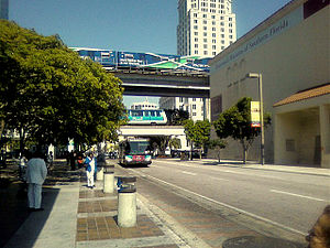
Metrorail (top), Metromover (middle), and Metrobus (bottom) at Government CenterInfo Locale Greater Miami Transit type Rapid transit, Downtown people mover, bus rapid transit, transit bus Number of lines 2 Metrorail lines
3 Metromover loops
110 Metrobus routes
1 bus rapid transit lineNumber of stations Miami Central Station
Government Center23 (Metrorail)
22 (Metromover)
28 (South Dade Busway)Daily ridership 391,000+ daily Chief executive Ysela Llort (Interim Director) Headquarters 701 NW 1st Court
Miami, Florida, 33132Operation Began operation August 2, 1960[1] Operator(s) Miami-Dade Transit Number of vehicles 893 buses
136 Metrorail cars
29 Metromover carsTechnical Track gauge 1,435 mm (4 ft 8 1⁄2 in) (standard gauge) Miami-Dade Transit (MDT) is the primary public transit authority of Miami, Florida, United States and the greater Miami-Dade County area. It is the largest transit system in Florida and the 12th-largest transit system in the United States.[2]
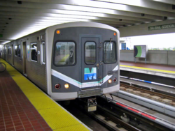
MDT operates the rapid transit Metrorail, the Downtown Metromover people mover, Metrobus, and Paratransit (STS) systems. Metrorail is composed of two rail lines (Green and Orange lines) with 23 stations radiating from the city center towards outlying neighborhoods north and south of Downtown. Metromover operates throughout the Downtown and Brickell neighborhoods, and is composed of three rail loops and 22 stations. Metrobus operates over 110 routes, including the South Dade Busway.[3] MDT's main transit stations are Government Center in Downtown, and the new Miami Central Station in Grapeland Heights, near Miami International Airport.[4]
As of 2011, MDT has a daily passenger ridership of 336,067, and accounts for over 15% of Miamians' daily transportation. MDT has seen growing passenger ridership since 1998, with ridership increasing 79% since then. The opening of the new Metrorail Orange Line in April 2012 is expected to significantly increase usage of the system.[5] Although not under the control of MDT, Tri-Rail is Miami's commuter rail system, and connects Miami to suburbs north to Fort Lauderdale and West Palm Beach.[6]
Currently, the Interim Director of the authority is Ysela Llort. The MDT headquarters are located in the Overtown Transit Village in Downtown Miami.[7]
Contents
History
In 1960, the Dade County Commission passed an ordinance creating the Metropolitan Transit Authority (MTA) to unify the different transit operations into one countywide service. This ordinance provided for the purchase, development, and operation of an adequate mass transit system by the County. These companies included the Miami Transit Company, Miami Beach Railway Company, South Miami Coach Lines, and Keys Transit Company on Key Biscayne and would be managed by National City Management Company. Over the years and under various administrations, MTA evolved into the Metro-Dade Transportation Administration, the Metro-Dade Transit Agency, the Miami-Dade Transit Agency, and is now known simply as Miami-Dade Transit (MDT).
Miami-Dade Transit, a county department of more than 4,000 employees, is the largest transit agency in the state of Florida and accounts for more than half of the trips taken on public transit in the state. MDT operates an accessible, integrated system of 100-plus Metrobus routes; the 22-mile (35 km) Metrorail rapid transit system; Metromover, a free downtown people mover system; and the Paratransit division’s Special Transportation Service. Metrobus routes cover more than 35-million miles annually, including limited service to Broward and Monroe counties. In 2004, MDT's Metrorail, Metromover, and Metrobus transported more than 96 million passengers, compared to 85 million the previous year.
2011 federal investigation
Miami-Dade Transit is undergoing a federal investigation by the Federal Transit Administration that includes several audits and a criminal investigation of the transit agency due to concerns over money mismanagement within the agency.[8] This caused a freezing of federal funds being granted to the county agency. In late 2010 the county manager claimed that it was 'not fraud' but rather accounting errors, poor management, and erroneous information given to the auditors that triggered the investigation, including a withdrawal of $15 million through the ECHO program that was made by a transit official two hours after a letter arrived in September 2010 from the FTA telling them withdrawals had been restricted.[9] The investigation and lack of funding let to emergency service cuts to Metrorail, Metrobus, and Metromover being considered by the agency by the middle of 2011, six months into the investigation and lack of funding which began in November 2010, causing MDT to lose $185 million in grant money. Assistant county manager Ysela Llort became responsible for Miami-Dade Transit after director Harpal Kapoor left in April 2011. Additionally, funding for the Metrorail airport link was jeopardized by the funding freeze. The FTA decided to continue funding under strict control in order to keep service cuts from happening.[10]
Improvement projects
- The Miami-Dade County Government has received federal money in order to purchase new and refurbish old Metrorail and Metromover cars, as they have been operating for more than 20 years.
- Technology and Corridor Improvements: Two corridors, totaling 24.4 miles (39.3 km) of rapid transit, have completed the planning phase and are ready to enter into final design and construction—the North Corridor, Earlington Heights-MIC Connection, and East-West Corridor.
Fares
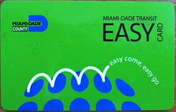 The EASY Card was implemented in 2009, and allows for fast and seamless transfers between Metrorail, Tri-Rail, Metromover and Metrobus.
 See also: EASY Card (South Florida)
The "EASY Card" system is a regional fare collection system with interoperable smartcards and equipment. The following information is specific to Miami-Dade Transit:
Since October 1, 2009, Miami-Dade Transit has used the EASY Card system[11] for fare collection.
On December 13, 2009 paper-based bus transfers were discontinued, and bus-to-bus transfers are now free only when using an EASY Card or EASY Ticket.
- An EASY Card can be purchased for $2 at EASY Card sales outlets, vending machines in Metrorail stations, calling 3-1-1 in Miami-Dade County, or online. Money can be reloaded on to the card at the same places and locations. The card lasts for 3 years from first use.
- Alternatively an EASY Ticket may be purchased with no sales charge. However EASY Tickets are limited to the fare type initially loaded onto it, and expire 60 days after purchase.[12] EASY Tickets also may not be purchased online or via telephone.
- With the change, paper transfers are being eliminated on transit. People paying fares in cash will need to pay full fare when transferring.[13] Transfers will be available only by paying with an EASY Card or Ticket and using the card again within 3 hours of boarding transit.
The current standard fare is $2.00 and reduced fare is $1.00. A standard monthly pass costs $100 and $50 for reduced fare. The monthly Metropass is loaded onto the EASY Card. Turnstile equipment at all Metrorail stations does not accept any type of cash,[11] and require an EASY Card or Ticket to both enter and exit the boarding area.
Reduced fares are available only to Medicare recipients, people with disabilities, and Miami-Dade students in grades 1-12.
All Miami-Dade senior citizens aged 65 years and older and with Social Security benefits ride free with a Golden Passport pass. Veterans residing in Miami-Dade and earning less than $22,000 annually ride free with the Patriot Passport pass.
Passenger ridership
In February 2011, Miami-Dade Transit ridership totaled 336,067 passengers, including all Metrorail, Metromover and Metrobus lines. With a population of about 2.5 million in Miami-Dade County, Miami-Dade Transit accounts for 15% of the population's daily mode of transportation. Note: This figure does not include Tri-Rail, Miami's commuter rail operator.
Daily passenger ridership averages
Year Metrobus Metrorail[14] Metromover Total ridership 1998 207,048 44,871 13,269 265,188 1999 209,111 46,774 13,880 269,765 2000 212,927 47,256 14,383 274,566 2001 211,823 46,664 16,849 275,336 2002 204,941 47,064 16,444 268,449 2003 215,306 51,248 25,521 292,076 2004 234,109 55,294 28,192 317,595 2005 246,023 59,700 28,473 334,195 2006 259,375 58,358 27,042 344,775 2007 264,467 59,708 28,058 352,233 2008 259,018 63,710 26,682 349,410 2009 233,858 59,992 25,883 319,733 2010 227,883 59,900 27,175 314,958 February 2011 243,878 65,300 29,878 336,067 Metrorail
Metrorail is an elevated rapid transit heavy rail system similar to a subway train that has one 22.4 main line from Hialeah to Kendall and an under construction line known as the Airport Link to Miami International Airport.
Metrorail line expansions
- The AirportLink is a 2.4-mile (3.9 km) extension from Earlington Heights Metrorail Station to the Miami Intermodal Center (north of NW 21st St. and east of NW 42nd Ave. at Miami International Airport). Construction is scheduled to be completed in late 2011, with Metrorail passenger service on the extension starting in early 2012.
- The North Corridor is a 9.5-mile (15.3 km) expansion will be a northward extension from the Dr. Martin Luther King, Jr. Plaza Metrorail Station, along NW 27th Avenue to NW 215th Street (Miami-Dade/Broward County line); with proposed stations at Northside Shopping Center, MDC-North Campus, City of Opa-locka, Bunche Park, Miami Gardens, Sun Life Stadium and the Calder Race Course. The project has been postponed indefinitely and has been deemed not eligible to federal funding.
- The East-West Corridor is a 10.6-mile (17.1 km) expansion from the Miami Intermodal Center west to the Palmetto Expressway (SR 826) and from the Palmetto, through West-Dade County and Florida Turnpike/FIU/117th Avenue. These sites have been identified as potential station locations: Florida International University, NW 107th Avenue (Avenue of the Americas), NW 97th Avenue, NW 87th Avenue (Galloway Road), NW 72nd Avenue (Milam Dairy Road), the Blue Lagoon area, and Miami Intermodal Center.
Metromover
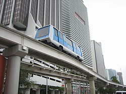
Metromover is a free, elevated, automated mass transit people mover that runs on three loops: the Downtown Inner Loop, Brickell Loop, and the Omni Loop. The systems totals 4.4 miles with 22 stations at roughly every two blocks in the greater Downtown area. Metromover serves the neighborhoods of Downtown, Brickell, Omni, Park West, and Overtown.
Metrobus
Metrobus 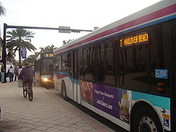
Locale Miami, Florida Service type bus service, bus rapid transit Routes 110 Fleet 900+ Daily ridership 293,000 [15] Operator Miami-Dade Transit The Metrobus network provides bus service throughout Miami-Dade County 365 days a year. It consists of more than 100 routes and 900 buses, which connect most points in the county and part of southern Broward County as well. Seven of these routes operate around the clock: Routes 3, 11, 27, 38, 77, L (No 24 hour Hialeah service)and S. Routes 246 Night Owl & Route 500 Midnight Owl operate from 12am to 5am. Most other routes operate from 5 AM to 11 PM. All Metrobuses are wheelchair accessible, in compliance with the Americans with Disabilities Act of 1990.
Bus route 301 (Dade-Monroe Express) extends into Monroe County, reaching Marathon, where a transfer is available to a Key West Transit bus proceeding further into the Keys. With the appropriate bus transfers, one can travel all the way from Key West to Jupiter entirely on public-transit buses.
South Miami-Dade Busway
The South Miami-Dade Busway (originally the South Dade Busway) began operating on February 3, 1997 and was extended in April 2005. The final 6.5-mile (10.5 km) segment of the Busway extension to Florida City opened on Sunday, December 16, 2007. It is parallel to US1/ S Dixie Highway, and replaced an abandoned Florida East Coast Railroad line. It is an alternative to daily traffic congestion. The 13-mile (21 km) roadway was built by the Florida Department of Transportation just for Metrobus routes and emergency vehicles. Express buses on the exclusive lanes shuttle passengers to and from Dadeland South Station (see Metrorail) in under 40 minutes.
Both full-size buses and minibuses operate on the Busway and in adjacent neighborhoods, entering the exclusive lanes at major intersections. Local and limited-stop service is offered between Florida City and Dadeland South Metrorail Station. Park & Ride lots along the busway are located at SW 152d Street (Coral Reef Drive), SW 168th Street (Richmond Drive), SW 200th Street (Caribbean Boulevard), SW 244th Street, and SW 296th Street. At Dadeland South Station, riders transfer to Metrorail. Riders headed downtown can transfer from Metrorail to Metromover, which consists of three shorter downtown loops, at Government Center Station.
The South Miami-Dade Busway features 28 stops, all of which have been converted to light-rail style stations. A multi-use path stretches the length of the Busway.
South Dade Busway stations
- SW 104th Street
- SW 112th Street
- SW 117th Street
- SW 124th Street
- SW 128th Street
- SW 136th Street
- SW 144th Street
- SW 152nd Street (Park-N-Ride)
- SW 160th Street
- SW 168th Street (Park-N-Ride)
- SW 173rd Street
- W Indigo Street
- SW 184th Street
- Marlin Road
- SW 200th Street
- SW 212th Street (Park-N-Ride)
- SW 216th Street
- SW 220th Street
- SW 232nd Street
- SW 244th Street
- SW 264th Street
- SW 272nd Street
- SW 280th Street
- SW 296th Street (Park-N-Ride)
- SW 312th Street
- Historic Homestead
- SW 324th Street
- SW 328th Street
- SW 344th Street
Routes that use the Busway
- 31 Busway Local- serves all stations between northern end of the busway and Southland Mall, before looping to serve Cutler Bay shopping centers and the South Dade Government Office Complex
- 34 Busway Flyer- travels the entire length of the busway, but does not stop at any stations before SW 152nd Street
- 38 Busway MAX- travels the entire length of the busway, deviating from the route slightly to serve Southland Mall, and travelling beyond the end of the busway to serve Florida City shopping centers
- 52- begins at Dadeland North Metrorail Station, then runs along busway to SW 152nd street, before becoming a Richmond Heights and Goulds local route
- 252 Coral Reef MAX- begins at Dadeland South Metrorail Station, then runs along busway to SW 152nd Street, before becoming express route to Country Walk
- 287 Saga Bay MAX- begins at Dadeland South Metrorail Station, then runs along busway to SW 168th Street, before running as express route through West Perrine and Saga Bay
Busway vs. rail controversy
The Busway has been the site of many accidents, as some car drivers driving south on US-1 (which runs parallel to the Busway for much of its length), and looking to turn west, do not stop at the red arrows that govern the right turn lane at an intersection that has a Busway crossing adjacent to it. They make a right turn and go right into the path of a bus that is entering the adjacent Busway intersection. Buses currently have to slow down to 15 mph (24 km/h) before crossing the intersection, and the police often patrol the intersections looking for red arrow runners. Surprisingly, even the intersections where the Busway runs as far as 2 blocks west of US-1 suffer the same problem, with car drivers either not seeing or flatly ignoring the red lights at SW 184th and 186th Streets. City planners and residents alike have commented that rather than dismantling the former Florida East Coast Railroad line for the busway, the Metrorail system could have been extended southward over the railway line.
Paratransit (STS)
Paratransit/Special Transportation Services (STS) is available for people with a mental or physical disability that cannot ride Metrobus, Metrorail, or Metromover. For $3.00 per one-way trip, STS offers shared-ride, door-to-door travel in accessible vehicles throughout most of Miami-Dade County, in some parts of south Broward County, and in the middle and northern Keys . STS operates 24 hours a day, seven days a week, including most holidays.
See also
- Transportation in Miami
- List of Miami-Dade Transit metro stations
- Tri-Rail, Miami's commuter rail system
- List of rapid transit systems
- List of United States railroads
- List of Florida railroads
References
- ^ http://scholar.library.miami.edu/miamidigital/1960s.php
- ^ http://www.contactlessnews.com/2008/07/10/cubic-wins-contract-to-update-miami-dade-transits-aging-fare-collection-system
- ^ http://www.miamidade.gov/transit/rider_busway.asp
- ^ http://www.micdot.com/miami_central_station.html
- ^ http://www.miamidade.gov/transit/news_technical_reports.asp
- ^ http://www.tri-rail.com/rider_info/system_map.htm
- ^ "Contact Us." Miami-Dade Transit. Retrieved on September 14, 2011. "Miami-Dade Transit Administrative Offices Overtown Transit Village 701 NW 1st Court Miami, Florida 33136"
- ^ Martha Brannigan and Alfonso Chardy (July 7, 2011). "Miami-Dade to weigh $100M loan for ailing Transit Agency". The Miami Herald. http://www.miamiherald.com/2011/07/07/2303266/miami-dade-county-commission-to.html. Retrieved 2011-07-07.
- ^ Alfonso Chardy (December 8, 2010). "Miami-Dade Transit's federal funding freeze `not fraud'". Miami Herald. http://www.miamiherald.com/2010/12/08/1962604/miami-dade-transits-federal-funding.html. Retrieved 2011-07-07.
- ^ Martha Brannigan, Alfonso Chardy and Matthew Haggman (May 10, 2011). "Miami-Dade transit agency eyes service cuts as feds hold back money". Miami Herald. http://www.miamiherald.com/2011/05/10/2211021/miami-dade-transit-agency-eyes.html. Retrieved 2011-07-07.
- ^ a b http://www.miamidade.gov/transit/library/pdfs/misc/english_easy_card_brochure_july2009.pdf
- ^ http://www.miamidade.gov/transit/easy_card.asp
- ^ http://www.miamidade.gov/transit/library/easy_card/transfers_poster.pdf
- ^ http://www.miamidade.gov/transit/news_technical_reports_archive.asp
- ^ http://miamitodaynews.com/news/090521/story1.shtml
External links
- Miami-Dade Transit
- Planned East-West Corridor Route Alignment Map (PDF)
- Planned East-West Corridor Station Locations
- Planned North Corridor Route Alignment Map
- Planned North Corridor Station Locations
- Citizens' Independent Transportation Trust
- Transit Miami (news and information blog)
- Public Transit (MDTA commuter blog)
Currently operating heavy rail rapid transit systems in the United States Massachusetts Bay Transportation Authority (Blue, Orange, and Red Lines) · MTA (New York City Subway and Staten Island Railway) · Port Authority Trans-Hudson · Southeastern Pennsylvania Transportation Authority (Market–Frankford and Broad Street lines) · PATCO Speedline · Baltimore Metro Subway · Washington Metro · Metropolitan Atlanta Rapid Transit Authority · Miami Metrorail · San Juan Tren Urbano · Cleveland Red Line · Chicago 'L' · Bay Area Rapid Transit · Los Angeles Metro Rail (Red and Purple Lines)
Public transportation systems in Florida Bus transportation Rail transportation JTA Skyway | Metromover | Metrorail | MIA Mover | SunRail | Tri-Rail | TECO Line
City of Miami Accent • Arts • Climate • Companies • Downtown • Education • Fire • Government • Historic Landmarks • History • Library • Mayors • Miamians • Music • Neighborhoods • Police • Skyscrapers • Sports • Television • Transportation
Greater Miami CBD Urban centers Major thoroughfares North 36th Street · North 79th Street · North 103rd Street · North 125th Street · West 7th Avenue · West 27th Avenue · West 107th Avenue · Allapattah Road · Alton Road · Bird Road · Biscayne Boulevard · Collins Avenue · Coral Reef Drive · Coral Way · County Line Road · Flagler Street · Galloway Road · Gratigny · Ives Dairy Road · Julia Tuttle Causeway · Kendall Drive · Killian · Krome Avenue · William H. Lehman Causeway · LeJeune Road · Ludlam Road · MacArthur Causeway · Miami Avenue · Miami Gardens Drive · Milam Dairy Road · Miracle Mile · Ocean Drive · Okeechobee Road · Old Cutler Road · Port Boulevard · Red Road · Rickenbacker Causeway · South Dixie Highway · Sunset Drive · Tamiami Trail · Venetian CausewayColleges and universities Parks and recreation Amelia Earhart Park · Arch Creek · The Barnacle Historic State Park · Bayfront Park · Bicentennial Park · Big Cypress National Preserve · Bill Baggs Cape Florida State Park · Biscayne National Park · Chapman Field Park · Crandon Park · Dinner Key · Everglades National Park · Fairchild Tropical Botanic Garden · Fort Dallas · Fruit and Spice Park · Greynolds Park · Haulover Park · The Kampong · Matheson Hammock Park · Oleta River State Park · Peacock Park · Shark Valley · South Pointe Park · Tamiami Park · Tropical Park · Virginia Key · Zoo MiamiMajor districts and attractions Adrienne Arsht Center for the Performing Arts · American Airlines Arena · Boca Chita Key Historic District · Coral Castle · Design District · Downtown Miami Historic District · Jungle Island · Lummus Park · Homestead Historic Downtown District · MacFarlane Homestead District · Miami Art Deco District · Miami Seaquarium · Monkey Jungle · Normandy Isles Historic District · North Shore Historic District · Miami Riverwalk · South Beach · Villa VizcayaMajor shopping centers Aventura Mall · Bal Harbour Shops · Bayside Marketplace · CocoWalk · Dadeland Mall · Dadeland Station · Dolphin Mall · The Falls · Lincoln Road Mall · The Mall at 163rd Street · Mall of the Americas · Mary Brickell Village · Metrofare Shops & Cafe · Miami International Mall · Miracle Marketplace · The Shops at Sunset Place · Southland Mall · Village of Merrick Park · Westland MallPrimary modes of transport Miami International Airport · Port of Miami · Miami Central Station · Miami-Dade Transit (Metrobus · Metrorail · Metromover) · Tri-RailCategories:- Miami-Dade Transit
- Transportation in Miami, Florida
- 1960 establishments
- Bus rapid transit in Florida
Wikimedia Foundation. 2010.


