- Cutler Bay, Florida
-
Cutler Bay, Florida — Town — Location in Miami-Dade County and the state of Florida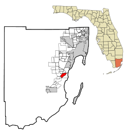 U.S. Census Bureau map showing town boundaries
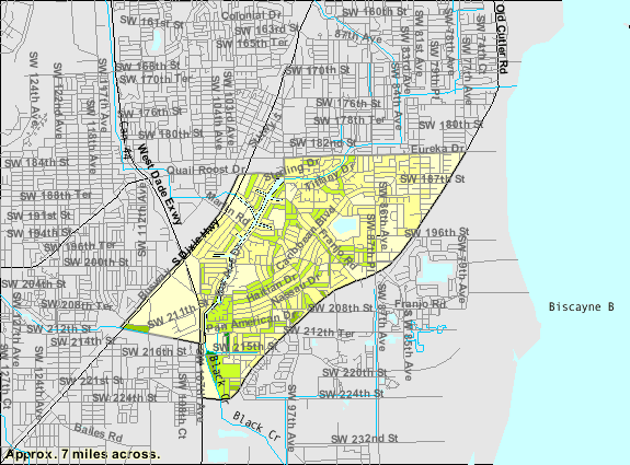
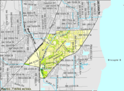
Coordinates: 25°34′57″N 80°20′48″W / 25.5825°N 80.34667°W Country  United States
State  Florida
County Miami-Dade Area - Total 4.9 sq mi (12.6 km2) - Land 4.8 sq mi (12.3 km2) - Water 0.1 sq mi (0.3 km2) Population (2000) - Total 24,781 - Density 5,057.3/sq mi (1,966.7/km2) Cutler Bay, historically called Cutler Ridge, is an incorporated town in Miami-Dade County, Florida from SW 184th Street (Eureka Dr) east of US-1 to the coast, and north of Black Point Marina, at 25°34′50″N 80°20′48″W / 25.58056°N 80.34667°W. As of the 2000 census, the area was known as the census-designated place of Cutler Ridge, which had a total population of 24,781.
In August 1992, the area was slammed by Hurricane Andrew. In August 2005, the area was hit with serious floods from Hurricane Katrina, which by radar estimates dropped over 20 inches or 500 mm of rainfall.
On January 11, 2005, residents on this unincorporated community voted to incorporate. In November 2005, residents adopted the municipal charter in which the fledgling city was renamed Cutler Bay. Both the current and former names were derived from the former town of Cutler, which existed at the turn of the century but was disincorporated during the depression. The actual location of Cutler was not within the current city limits of Cutler Bay, but was in fact two miles (3 km) to the north, east of the former Perrine and inside the boundaries of the current municipality of Palmetto Bay.
In January 2006, Cutler Bay elected former Florida state legislator John F. Cosgrove as its first mayor. Mayor Cosgrove died on April 19, 2006, while vacationing in Zimbabwe.[1] Vice Mayor Paul Vrooman assumed the position of Mayor.
Cutler Bay is also home to the Southland Mall, which was formerly named Cutler Ridge Mall.
Contents
Geography
Cutler Bay is located at 25°34′58″N 80°20′48″W / 25.582684°N 80.346799°WCoordinates: 25°34′58″N 80°20′48″W / 25.582684°N 80.346799°W.[2]
According to the United States Census Bureau, the CDP had a total area of 4.9 square miles (13 km2). 4.8 square miles (12 km2) of it is land and 0.1 square miles (0.26 km2) of it (2.26%) is water.
Surrounding areas
- Palmetto Bay
- West Perrine


 Palmetto Bay
 - Unincorporated Miami-Dade County, South Miami Heights, Goulds

 Lakes by the Bay
 - Goulds, Princeton


 Unincorporated Miami-Dade County
 - Goulds, Unincorporated Miami-Dade County, Lakes by the Bay
Demographics
As of the census[3] of 2000, there were 24,781 people, 8,396 households, and 6,322 families residing in the CDP. The population density was 5,213.4 inhabitants per square mile (2,014.3/km²). There were 8,725 housing units at an average density of 1,835.6 per square mile (709.2/km²). The racial makeup of the CDP was 73.72% White (44.4% were Non-Hispanic White,)[4] 15.68% African American, 0.27% Native American, 1.73% Asian, 0.07% Pacific Islander, 4.78% from other races, and 3.76% from two or more races. Hispanic or Latino of any race were 36.75% of the population.
There were 8,396 households out of which 40.8% had children under the age of 18 living with them, 53.6% were married couples living together, 16.4% had a female householder with no husband present, and 24.7% were non-families. 19.9% of all households were made up of individuals and 9.8% had someone living alone who was 65 years of age or older. The average household size was 2.91 and the average family size was 3.35.
In the CDP the population was spread out with 29.1% under the age of 18, 7.9% from 18 to 24, 31.6% from 25 to 44, 20.2% from 45 to 64, and 11.2% who were 65 years of age or older. The median age was 34 years. For every 100 females there were 92.7 males. For every 100 females age 18 and over, there were 86.9 males.
The median income for a household in the CDP was $45,917, and the median income for a family was $50,956. Males had a median income of $34,940 versus $27,565 for females. The per capita income for the CDP was $18,559. About 9.2% of families and 11.5% of the population were below the poverty line, including 14.3% of those under age 18 and 18.0% of those age 65 or over.
As of 2000, speakers of English as a first language accounted for 58.89%, while Spanish made up 38.18%, and French Creole comprised 1.31% of the population.[5]
Population history of Cutler Bay 1960 7,005 1970 17,441 1980 20,886 1990 21,268 2000 24,781 NOTE: All figures were taken prior to incorporation and the area was known as Cutler Ridge. Source: The United States Census Bureau As of 2000, Cutler Bay had the thirty-fifth highest percentage of Cuban residents in the US, with 13.37% of the populace.[6] It had the 151st highest percentage of Puerto Rican residents in the US, at 6.56% of the town's population,[7] and the eighty-second highest percentage of Colombian residents in the US, at 1.9% of its population.[8] It also had the ninety-fifth most Dominicans in the US, at 1.66% (tied with Palisades Park, New Jersey,)[9] while it had the twenty-ninth highest percentage of Nicaraguans, at 1.43% of all residents.[10]
Government and infrastructure
The Miami-Dade Police Department operates the South District Station in Cutler Bay.[11]
Education
Colleges and Universities
- College of Business & Technology (Cutler Bay Campus)
References
- ^ Past National President John Cosgrove enters Chapter Eternal at 56
- ^ "US Gazetteer files: 2010, 2000, and 1990". United States Census Bureau. 2011-02-12. http://www.census.gov/geo/www/gazetteer/gazette.html. Retrieved 2011-04-23.
- ^ "American FactFinder". United States Census Bureau. http://factfinder.census.gov. Retrieved 2008-01-31.
- ^ "Demographics of Cutler Bay (Cutler Ridge,) FL". MuniNetGuide.com. http://www.muninetguide.com/states/florida/municipality/Cutler_Ridge.php. Retrieved 2007-12-18.
- ^ "MLA Data Center Results of Cutler Bay (Cutler Ridge,) FL". Epodunk.com. http://www.mla.org/map_data_results&state_id=12&county_id=&mode=&zip=&place_id=15975&cty_id=&ll=&a=&ea=&order=r. Retrieved 2007-11-03.
- ^ "Ancestry Map of Cuban Communities". Epodunk.com. http://www.epodunk.com/ancestry/Cuban.html. Retrieved 2007-11-03.
- ^ "Ancestry Map of Puerto Rican Communities". Epodunk.com. http://www.epodunk.com/ancestry/Puerto-Rican.html. Retrieved 2007-11-03.
- ^ "Ancestry Map of Colombian Communities". Epodunk.com. http://www.epodunk.com/ancestry/Colombian.html. Retrieved 2007-11-03.
- ^ "Ancestry Map of Dominican Communities". Epodunk.com. http://www.epodunk.com/ancestry/Dominican-Republic.html. Retrieved 2007-11-03.
- ^ "Ancestry Map of Nicaraguan Communities". Epodunk.com. http://www.epodunk.com/ancestry/Nicaraguan.html. Retrieved 2007-11-03.
- ^ "South District Station." Miami-Dade Police Department. Retrieved on March 12, 2010.
External links
Categories:- Towns in Miami-Dade County, Florida


Wikimedia Foundation. 2010.