- Bal Harbour, Florida
Infobox Settlement
official_name = Bal Harbour, Florida
other_name =
native_name =
nickname =
settlement_type = Village
motto =
imagesize =
image_caption =
flag_size =
image_
seal_size =
image_shield =
shield_size =
image_blank_emblem =
blank_emblem_type =
blank_emblem_size =
imagesize =
image_caption =
flag_size =
image_
seal_size =
image_shield =
shield_size =
image_blank_emblem =
blank_emblem_type =
blank_emblem_size =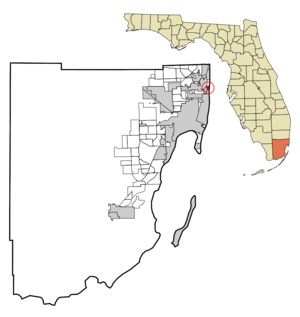
mapsize = 250x200px
map_caption = Location in Miami-Dade County and the state ofFlorida 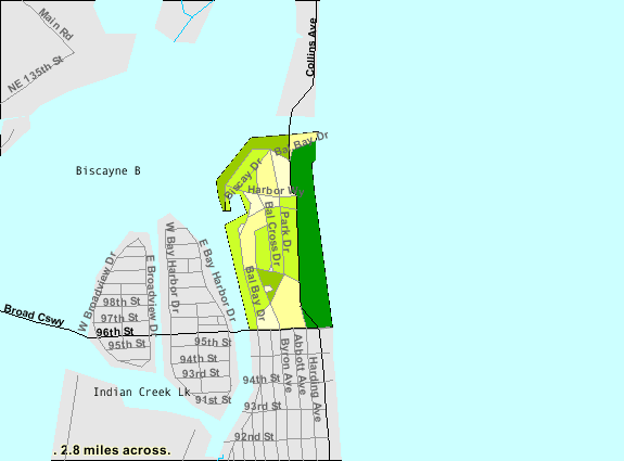
mapsize1 = 250x200px
map_caption1 = U.S. Census Bureau map showing village boundaries
image_dot_
dot_mapsize =
dot_map_caption =
dot_x =
dot_y =
pushpin_
pushpin_label_position =
pushpin_map_caption =
pushpin_mapsize =
subdivision_type = Country
subdivision_name = flag|United States
subdivision_type1 = State
subdivision_name1 = flag|Florida
subdivision_type2 = County
subdivision_name2 = noflag|Miami-Dade
subdivision_type3 =
subdivision_name3 =
subdivision_type4 =
subdivision_name4 =
government_footnotes =
government_type =
leader_title =
leader_name =
leader_title1 =
leader_name1 =
leader_title2 =
leader_name2 =
leader_title3 =
leader_name3 =
leader_title4 =
leader_name4 =
established_title =
established_date =
established_title2 =
established_date2 =
established_title3 =
established_date3 =
area_magnitude =
unit_pref = Imperial
area_footnotes =
area_total_km2 = 1.6
area_land_km2 = 0.9
area_water_km2 = 0.7
area_total_sq_mi = 0.6
area_land_sq_mi = 0.3
area_water_sq_mi = 0.3
area_water_percent =
area_urban_km2 =
area_urban_sq_mi =
area_metro_km2 =
area_metro_sq_mi =
area_blank1_title =
area_blank1_km2 =
area_blank1_sq_mi =
population_as_of = 2000
population_footnotes =
population_note =
population_total = 3305
population_density_km2 = 2065.6
population_density_sq_mi = 5508.3
population_metro =
population_density_metro_km2 =
population_density_metro_sq_mi =
population_urban =
population_density_urban_km2 =
population_density_urban_sq_mi =
population_blank1_title =
population_blank1 =
population_density_blank1_km2 =
population_density_blank1_sq_mi =
timezone = Eastern (EST)
utc_offset = -5
timezone_DST = EDT
utc_offset_DST = -4
latd = 25 |latm = 53 |lats = 35 |latNS = N
longd = 80 |longm = 7 |longs = 33 |longEW = W
elevation_footnotes =
elevation_m = 0
elevation_ft = 0
postal_code_type =ZIP code
postal_code = 33154
area_code = 305
blank_name = FIPS code
blank_info = 12-03275GR|2
blank1_name = GNIS feature ID
blank1_info = 0278057GR|3
website =
footnotes =Bal Harbour is a village in Miami-Dade County,
Florida ,United States . The population was 3,305 at the 2000 census.Geography
Bal Harbour is located at coor dms|25|53|35|N|80|7|33|W|city (25.893005, -80.125729)GR|1.
According to the
United States Census Bureau , the village has a total area of 1.5 km² (0.6 mi²). 0.9 km² (0.3 mi²) of it is land and 0.6 km² (0.2 mi²) of it (42.37%) is water.Bal Harbour Florida is located on the northern tip of the barrier island commonly referred to as Miami Beach.
The main traffic corridor running south to north through Bal Harbour is Collins Avenue, also demarked as Florida State Highway A1A.
A channel between the north end of Biscayne Bay and the Atlantic ocean runs across the northern end of Bal Harbour.
A bridge, maintained by the State of Florida connects Bal Harbour to Haulover Park, to the north. Haulover Park is maintained by the Miami Dade Parks Commission.
Demographics
As of the
census GR|2 of 2000, there were 3,305 people, 1,908 households, and 812 families residing in the village. Thepopulation density was 3,753.1/km² (9,791.4/mi²). There were 3,150 housing units at an average density of 3,577.1/km² (9,332.2/mi²). The racial makeup of the village was 94.46% White (73.4% were Non-Hispanic White,) [cite web |url=http://www.muninetguide.com/states/florida/municipality/Bal_Harbour.php |title=Demographics of Bal Harbour, FL |publisher=MuniNetGuide.com |accessdate=2007-10-28] 1.63% African American, 0.00% Native American, 0.82%Asia n, 0.09% Pacific Islander, 1.12% from other races, and 1.88% from two or more races. 23.00% of the population areHispanic orLatino of any race.There were 1,908 households out of which 9.2% had children under the age of 18 living with them, 36.1% were married couples living together, 4.8% had a female householder with no husband present, and 57.4% were non-families. 50.7% of all households were made up of individuals and 24.9% had someone living alone who was 65 years of age or older. The average household size was 1.73 and the average family size was 2.49.
In the village the population was spread out with 10.2% under the age of 18, 3.7% from 18 to 24, 24.0% from 25 to 44, 24.7% from 45 to 64, and 37.5% who were 65 years of age or older. The median age was 55 years. For every 100 females there were 75.8 males. For every 100 females age 18 and over, there were 73.6 males.
The median income for a household in the village was $47,148, and the median income for a family was $83,570. Males had a median income of $51,227 versus $44,500 for females. The
per capita income for the village was $67,680. About 5.6% of families and 9.2% of the population were below thepoverty line , including 10.5% of those under age 18 and 6.7% of those age 65 or over.As of 2000, speakers of English as a
first language accounted for 58.29% of residents, while Spanish was at 35.13%, Polish at 2.62%, French 2.13%, Portuguese 0.98%, and Russian made up 0.82% of the population. [cite web |url=http://www.mla.org/map_data_results&state_id=12&county_id=&mode=place&zip=&place_id=3275&cty_id=&ll=&a=&ea=&order=r |title=MLA's Data Center Results of Bal Harbour, FL |publisher=Modern Language Association |accessdate=2007-10-28]History
Since the 1920s, the Detroit-based Miami Beach Heights Corporation (headed by industrialists Robert C. Graham, Walter O. Briggs, and C.T. Fisher) owned convert|245|acre|km2 of undeveloped, partially swampy land that stretched from the bay to the Atlantic. Mr. Graham assumed the duties as the developer for Bal Harbour. In the 1930s, city planners
Harland Bartholomew & Associates were called in to design the Village. The company made several plans and they were submitted for review to Miami Beach Heights.In 1940, World War II began and the plans were put on hold. As a goodwill gesture to the government, Robert C. Graham rented the land to the United States Air Corps for $1 per year. The Air Corps used this land to train their soldiers and established a Prisoner of War camp. The ocean front area was used as a rifle range and the barracks were set up on the west side of Collins Avenue. The camp for prisoners was located where the Bal Harbour Shops are presently.
In 1945, the war was over in both Germany and Japan. The Air Corps left the barracks buildings as a thank you to the owners of the property. These barracks were converted into apartment homes by Mr. Graham in 1946.
In order to incorporate a city in 1946, there had to be at least 25 male registered voters residing in the area. Mr. Graham had twenty five families move into the apartment homes that he had converted in order to qualify the Village for incorporation. He then hired Willard Webb, a Miami Beach tax assessor, to draft a charter for the Village. After the charter was completed, the Village of Bal Harbour was incorporated on August 14, 1946, by Mr. Graham and 25 male registered voters. The Village was operated under the city manager form of government.
The Council established a volunteer
fire department .Swampland was filled, sea walls were constructed and the yacht basin was created. Contracts were signed for the sewer systems, water pumping stations and utilities. Bal Harbour was the first planned community in Florida to have its utilities placed underground. Developers set guidelines for the development of the beachfront and the residential areas. Collins Avenue was paved into four lanes with a landscaped median and later widened to the present day six lanes. Village plans indicated that ocean front property was to be convert|200|ft|m deep and lots approached $100,000. Lots in the residential area were about convert|1800|sqft|m2 and cost from $6,500 to $20,000.
The first hotel was built and was named "The Kenilworth By-the-Sea." It was built by Tom Raffington and made famous by Arthur Godfrey. It has since been demolished and is now the Kenilworth Condominium. The first home was built at 160 Bal Cross Drive. It was built by Mr. Robert C. Graham Jr., who was the son of Bal Harbour Developer Robert C. Graham. Construction for the Sea View Hotel was started.
Bal Harbour Village was re-incorporated by a special act of the 1947
Florida Legislature and its own charter was issued June 16th. This new charter supplemented the original incorporation under the General Laws of Florida. In accordance with the new charter, an election to select five to serve on the Council was held June 30th. The Council elected were: Edward L. Bonneau, Robert C. Graham, Jr., Glenn E. Massnick, George Whittaker, and Judge Julien Southerland. Judge Southerland was chosen as mayor. Willard Webb, who had been acting manager since the first organization, was appointed as Village Manager. Mary Wetterer was named Village Clerk and Herold Dickey was appointed Chief of Police.*In 1947, the Church by the Sea was built.
*In 1948, the Beach Club was built. Its restaurant was operated byHoward Johnson's .
*In 1949, a new bridge was started over Baker Haulover.
*In 1956, the current Village Hall was built.
*In 1956, the Hotel Americana was built. It became theSheraton Hotel in 1980. It was imploded onNovember 18 ,2007 to build a set of condos and a luxury aparthotel as the St. Regis. [http://cbs4.com/local/bal.harbour.implosion.2.570600.html Sheraton Bal Harbour Vanishes In A Cloud Of Dust]
*In 1959, Bal Harbour's beach was renovated due to severe erosion.
*In 1965, theBal Harbour Shops was built by the Whitman family. Stanley Whitman was one of the incorporators who lived with his family in the barrack apartments.
*In 1971, Bal Harbour's beach started a major renourishment project. [http://www.balharbourgov.com/government/history.html Bal Harbour :: The official website for Bal Harbour Village, Florida ] ]
*In 2008, The new Regent Bal Harbour opened, becoming the northern gateway to the Village.http://www.balharbourgov.com/government/history.html balharbourgov.com]Name
The original name chosen for Bal Harbour was Bay Harbour. However, the planning committee didn't think that was appropriate for a city that was on the beach.
A name was invented to encompass a city that ran from the bay to the Atlantic Ocean. The "b" was taken from the word bay and the "a" and "l" were taken from the word Atlantic.
Hence the word "Bal" was created.
References
External links
* [http://www.balharbourflorida.com/ Village of Bal Harbour] official website
* [http://www.balharbourshops.com Bal Harbour Shops] upscale mall
* [http://www.southbeach-usa.com/shopping/bal-harbour-shops/bal-harbour-shops.htm Bal Harbour Shops - Selected Boutiques]
Wikimedia Foundation. 2010.