- Virginia Gardens, Florida
Infobox Settlement
official_name = Virginia Gardens, Florida
other_name =
native_name =
nickname =
settlement_type = Village
motto =
imagesize =
image_caption =
flag_size =
image_
seal_size =
image_shield =
shield_size =
image_blank_emblem =
blank_emblem_type =
blank_emblem_size =
mapsize = 250x200px
map_caption = Location in Miami-Dade County and the state ofFlorida 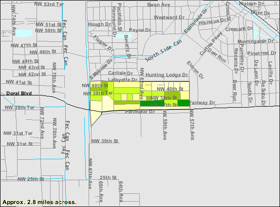
mapsize1 = 250x200px
map_caption1 = U.S. Census Bureau map showing village boundaries
image_dot_
dot_mapsize =
dot_map_caption =
dot_x =
dot_y =
pushpin_
pushpin_label_position =
pushpin_map_caption =
pushpin_mapsize =
subdivision_type = Country
subdivision_name = flag|United States
subdivision_type1 = State
subdivision_name1 = flag|Florida
subdivision_type2 = County
subdivision_name2 = noflag|Miami-Dade
subdivision_type3 =
subdivision_name3 =
subdivision_type4 =
subdivision_name4 =
government_footnotes =
government_type =
leader_title =Mayor
leader_name = Spencer Deno IV
leader_title1 =
leader_name1 =
leader_title2 =
leader_name2 =
leader_title3 =
leader_name3 =
leader_title4 =
leader_name4 =
established_title =
established_date =
established_title2 = Incorporated
established_date2 =1947
established_title3 =
established_date3 =
area_magnitude =
unit_pref = Imperial
area_footnotes =
area_total_km2 = 0.8
area_land_km2 = 0.8
area_water_km2 = 0
area_total_sq_mi = 0.3
area_land_sq_mi = 0.3
area_water_sq_mi = 0
area_water_percent = 0
area_urban_km2 =
area_urban_sq_mi =
area_metro_km2 =
area_metro_sq_mi =
area_blank1_title =
area_blank1_km2 =
area_blank1_sq_mi =
population_as_of = 2000
population_footnotes =
population_note =
population_total = 2,348
population_density_km2 = 3,021.9
population_density_sq_mi = 7,820.6
population_metro = 5422200
population_density_metro_km2 =
population_density_metro_sq_mi =
population_urban =
population_density_urban_km2 =
population_density_urban_sq_mi =
population_blank1_title =
population_blank1 =
population_density_blank1_km2 =
population_density_blank1_sq_mi =
timezone = EST
utc_offset = -5
timezone_DST = EDT
utc_offset_DST = -4
latd = 25 |latm = 48 |lats = 33.03 |latNS = N
longd = 80 |longm = 17 |longs = 48.11 |longEW = W
elevation_footnotes =
elevation_m = 1
elevation_ft = 3
postal_code_type = Zip Codes
postal_code = 33166
area_code = 305, 786
blank_name = FIPS code
blank_info = 12-74575GR|2
blank1_name = GNIS feature ID
blank1_info = 0292782GR|3
website =
footnotes = http://www.virginiagardens-fl.gov/Virginia Gardens is a village in Miami-Dade County,
Florida ,United States . The population was 2,348 at the 2000 census. According to theU.S. Census Bureau 's2004 estimates, the village had a population of 2,294.History
The tiny enclave of Virginia Gardens was born out of the love of horses. In 1947, neighboring Miami Springs passed an ordinance outlawing horses from their city limits, so about 50 citizens decided to form their own city next door.
Virginia Gardens got its name because many of the founding residents were wealthy transplants who aptly named the village after their home state. At the time of incorporation, many of the residents owned large estates, some up to five acres, where they could ride and enjoy their horses.
Geography
Virginia Gardens is located at coor dms|25|48|33|N|80|17|48|W|city (25.809175, -80.296697)GR|1.
According to the
United States Census Bureau , the village has a total area of 0.8km² (0.3 mi²), all land.Demographics
As of the
census GR|2 of 2000, there were 2,348 people, 890 households, and 596 families residing in the village. Thepopulation density was 3,021.9/km² (7,820.6/mi²). There were 925 housing units at an average density of 1,190.5/km² (3,080.9/mi²). The racial makeup of the village was 85.35% White (28.6% were Non-Hispanic Whites,) [cite web |url=http://www.muninetguide.com/states/florida/municipality/Virginia_Gardens.php |title=Demographics of Virginia Gardens, FL |publisher=MuniNetGuide.com |accessdate=2007-10-31] 2.26% African American, 0.17% Native American, 1.53% Asian, 0.00% Pacific Islander, 4.73% from other races, and 5.96% from two or more races. Hispanic or Latino of any race were 67.25% of the population.There were 890 households out of which 31.7% had children under the age of 18 living with them, 47.3% were married couples living together, 14.9% had a female householder with no husband present, and 33.0% were non-families. 27.1% of all households were made up of individuals and 7.9% had someone living alone who was 65 years of age or older. The average household size was 2.63 and the average family size was 3.22.
In the village the population was spread out with 23.0% under the age of 18, 7.6% from 18 to 24, 31.9% from 25 to 44, 23.9% from 45 to 64, and 13.5% who were 65 years of age or older. The median age was 38 years. For every 100 females there were 97.5 males. For every 100 females age 18 and over, there were 93.1 males.
The median income for a household in the village was $40,197, and the median income for a family was $44,800. Males had a median income of $31,302 versus $26,274 for females. The
per capita income for the village was $21,139. About 9.5% of families and 11.3% of the population were below thepoverty line , including 16.3% of those under age 18 and 6.6% of those age 65 or over.As of 2000, speakers of Spanish as a
first language made up 71.66%, and English as amother tongue accounted for 28.33% of the population. [cite web |url=http://www.mla.org/map_data_results&state_id=12&county_id=&mode=place&zip=&place_id=74575&cty_id=&ll=&a=&ea=&order=r |title=MLA Data Center Results of Virginia Gardens, FL |publisher=Modern Language Association |accessdate=2007-10-31]As of 2000, Virginia Gardens had the nineteenth highest percentage of Cuban residents in the US, with 26.11% of the populace. [cite web |url=http://www.epodunk.com/ancestry/Cuban.html |title=Ancestry Map of Cuban Communities |publisher=Epodunk.com |accessdate=2007-10-31] It had the tenth highest percentage of Colombian residents in the US, at 7.16% of the village's population, [cite web |url=http://www.epodunk.com/ancestry/Colombian.html |title=Ancestry Map of Colombian Communities |publisher=Epodunk.com |accessdate=2007-10-31] and the seventh highest percentage of Peruvian residents in the US, at 3.24% of the it's population. [cite web |url=http://www.epodunk.com/ancestry/Peruvian.html |title=Ancestry Map of Peruvian Communities |publisher=Epodunk.com |accessdate=2007-10-31] It also had the fifteenth most Nicaraguans in the US, at 2.51%, [cite web |url=http://www.epodunk.com/ancestry/Nicaraguan.html |title=Ancestry Map of Nicaraguan Communities |publisher=Epodunk.com |accessdate=2007-10-31] while it had the sixtieth highest percentage of Dominicans, at 2.39% of all residents (tied with North Miami Beach.) [cite web |url=http://www.epodunk.com/ancestry/Dominican-Republic.html |title=Ancestry Map of Dominican Communities |publisher=Epodunk.com |accessdate=2007-10-31] Virginia Gardens' Venezuelan community had the eighth highest percentage of residents, which was at a 1.58% populace, [cite web |url=http://www.epodunk.com/ancestry/Venezuelan.html |title=Ancestry Map of Venezuelan Communities |publisher=Epodunk.com |accessdate=2007-10-31] while the Guatemalan community had the ninety-eighth highest percentage of residents, which was at 1.15% (tied with Bokeelia, FL.) [cite web |url=http://www.epodunk.com/ancestry/Guatemalan.html |title=Ancestry Map of Guatemalan Communities |publisher=Epodunk.com |accessdate=2007-10-31] It's also home to the forty-sixth highest percentage of Ecuadorian residents in the US, at 1.32% of the population, [cite web |url=http://www.epodunk.com/ancestry/Ecuadorian.html |title=Ancestry Map of Ecuadorian Communities |publisher=Epodunk.com |accessdate=2007-10-31] as well as being home to the forty-second highest percentage of Honduran, at 1.11% (tied with
Atlantic City, New Jersey .) [cite web |url=http://www.epodunk.com/ancestry/Honduran.html |title=Ancestry Map of Honduran Communities |publisher=Epodunk.com |accessdate=2007-10-31]Education
Virginia Gardens is a part of
Miami-Dade County Public Schools .Public High School
*
Miami Springs High School serves Virginia Gardens.External links
* [http://www.virginiagardens-fl.gov/ Village of Virginia Gardens] official website
References

Wikimedia Foundation. 2010.