- Goulds, Florida
Infobox Settlement
official_name = Goulds, Florida
other_name =
native_name =
nickname =
settlement_type = CDP
motto =
imagesize =
image_caption =
flag_size =
image_
seal_size =
image_shield =
shield_size =
image_blank_emblem =
blank_emblem_type =
blank_emblem_size =
imagesize =
image_caption =
flag_size =
image_
seal_size =
image_shield =
shield_size =
image_blank_emblem =
blank_emblem_type =
blank_emblem_size =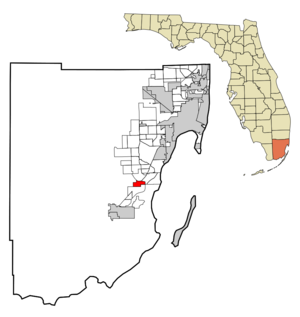
mapsize = 250x200px
map_caption = Location in Miami-Dade County and the state ofFlorida 
mapsize1 = 250x200px
map_caption1 = U.S. Census Bureau map showing CDP boundaries
image_dot_
dot_mapsize =
dot_map_caption =
dot_x =
dot_y =
pushpin_
pushpin_label_position =
pushpin_map_caption =
pushpin_mapsize =
subdivision_type = Country
subdivision_name = flag|United States
subdivision_type1 = State
subdivision_name1 = flag|Florida
subdivision_type2 = County
subdivision_name2 = noflag|Miami-Dade
subdivision_type3 =
subdivision_name3 =
subdivision_type4 =
subdivision_name4 =
government_footnotes =
government_type =
leader_title =
leader_name =
leader_title1 =
leader_name1 =
leader_title2 =
leader_name2 =
leader_title3 =
leader_name3 =
leader_title4 =
leader_name4 =
established_title =
established_date =
established_title2 =
established_date2 =
established_title3 =
established_date3 =
area_magnitude =
unit_pref = Imperial
area_footnotes =
area_total_km2 = 7.7
area_land_km2 = 7.7
area_water_km2 = 0
area_total_sq_mi = 3
area_land_sq_mi = 3
area_water_sq_mi = 0
area_water_percent =
area_urban_km2 =
area_urban_sq_mi =
area_metro_km2 =
area_metro_sq_mi =
area_blank1_title =
area_blank1_km2 =
area_blank1_sq_mi =
population_as_of = 2000
population_footnotes =
population_note =
population_total = 7453
population_density_km2 = 967.9
population_density_sq_mi = 2484.3
population_metro =
population_density_metro_km2 =
population_density_metro_sq_mi =
population_urban =
population_density_urban_km2 =
population_density_urban_sq_mi =
population_blank1_title =
population_blank1 =
population_density_blank1_km2 =
population_density_blank1_sq_mi =
timezone = Eastern (EST)
utc_offset = -5
timezone_DST = EDT
utc_offset_DST = -4
latd = 25 |latm = 33 |lats = 39 |latNS = N
longd = 80 |longm = 23 |longs = 0 |longEW = W
elevation_footnotes =
elevation_m = 3
elevation_ft = 10
postal_code_type =ZIP code
postal_code = 33170
area_code = 305
blank_name = FIPS code
blank_info = 12-26950GR|2
blank1_name = GNIS feature ID
blank1_info = 0283239GR|3
website =
footnotes =Goulds is a
census-designated place (CDP) in Miami-Dade County,Florida ,United States . The area developed originally as a stop on theFlorida East Coast Railroad . The railroad depot was located near today's Southwest 216th Street. The community was named after its operator, Lyman Gould, who cut trees for railroad ties. The downtown area had a post office, a grocery store and an apartment building. Most of this former downtown area is now a part of the Cauley Square shops. The population was 7,453 at the 2000 census.Geography
Goulds is located at coor dms|25|33|39|N|80|23|0|W|city (25.560885, -80.383353)GR|1.
According to the
United States Census Bureau , the CDP has a total area of 3.0square mile s (7.7km² ), all of it land.History
The area that became Goulds was settled in 1900 by homesteaders. It received its name when the
Florida East Coast Railway built a siding in 1903, operated by an employee of the railroad named Goulds. It was first known as Gould's Siding, and later shortened to Goulds. Manypacking house s were built along Old Dixie Highway. Early on Goulds had a reputation as a rough town, with several saloons serving itinerant field workers. Most of the packing houses were destroyed by a tornado in 1919, or the1926 Miami Hurricane , but were rebuilt. [Taylor, Jean. (1986) "The Villages of South Dade". St. Petersburg, Florida: Byron Kennedy and Company. ISBN 0-041072-12-6 Pp. 89-90.]Demographics
As of the
census GR|2 of 2000, there were 7,453 people, 2,214 households, and 1,762 families residing in the CDP. Thepopulation density was 2,514.5 people per square mile (972.2/km²). There were 2,367 housing units at an average density of 798.6/sq mi (308.8/km²). The racial makeup of the CDP was 15.22% White (4.9% were Non-Hispanic White,) [cite web |url=http://www.muninetguide.com/states/florida/municipality/Goulds.php |title=Demographics of Goulds, FL |publisher=MuniNetGuide.com |accessdate=2007-11-06] 78.13% African American, 0.17% Native American, 0.54% Asian, 0.01% Pacific Islander, 3.48% from other races, and 2.46% from two or more races. Hispanic or Latino of any race were 16.36% of the population.There were 2,214 households out of which 45.5% had children under the age of 18 living with them, 31.5% were married couples living together, 41.2% had a female householder with no husband present, and 20.4% were non-families. 15.7% of all households were made up of individuals and 5.2% had someone living alone who was 65 years of age or older. The average household size was 3.37 and the average family size was 3.72.
In the CDP the population was spread out with 38.4% under the age of 18, 10.9% from 18 to 24, 25.1% from 25 to 44, 16.3% from 45 to 64, and 9.2% who were 65 years of age or older. The median age was 26 years. For every 100 females there were 86.8 males. For every 100 females age 18 and over, there were 77.3 males.
The median income for a household in the CDP was $19,633, and the median income for a family was $21,728. Males had a median income of $23,165 versus $20,017 for females. The
per capita income for the CDP was $8,649. About 37.6% of families and 43.6% of the population were below thepoverty line , including 56.6% of those under age 18 and 32.3% of those age 65 or over.As of 2000, speakers of English as a
first language accounted for 83.54% of residents, while Spanish made up 15.42%, and French Creole was at 1.02% of the population. [cite web |url=http://www.mla.org/map_data_results&state_id=12&county_id=&mode=place&zip=&place_id=26950&cty_id=&ll=&a=&ea=&order=r |title=MLA Data Center Results of Goulds, FL |publisher=Modern Language Association |accessdate=2007-11-06]As of 2000, Goulds had the eighty-fourth highest percentage of African-American and black residents in the US, with 78.10% of the populace. [cite web |url=http://www.epodunk.com/ancestry/African-American.html |title=Ancestry Map of African-American Communities |publisher=Epodunk.com |accessdate=2007-11-06] It had the third highest percentage of Bahamian residents in the US, at 2.0% of the population, [cite web |url=http://www.epodunk.com/ancestry/Bahamian.html |title=Ancestry Map of Bahamian Communities |publisher=Epodunk.com |accessdate=2007-11-06] and the sixty-ninth highest percentage of Cuban residents in the US, at 4.70% of its population. [cite web |url=http://www.epodunk.com/ancestry/Cuban.html |title=Ancestry Map of Cuban Communities |publisher=Epodunk.com |accessdate=2007-11-06] It also had the thirty-second most Jamaicans in the US, at 4.10% (tied with Tamarac and Royal Palm Beach,) [cite web |url=http://www.epodunk.com/ancestry/Jamaican.html |title=Ancestry Map of Jamaican Communities |publisher=Epodunk.com |accessdate=2007-11-06] while it had the fifty-fourth highest percentage of Haitians, at 2.70% of all residents (tied with
Jewett City, Connecticut ,Georgetown, Delaware and Elizabeth, NJ.) [cite web |url=http://www.epodunk.com/ancestry/Haitian.html |title=Ancestry Map of Haitian Communities |publisher=Epodunk.com |accessdate=2007-11-06] Goulds' Nicaraguan community had the thirty-sixth highest percentage of residents, which was at 1.15% of the population. [cite web |url=http://www.epodunk.com/ancestry/Nicaraguan.html |title=Ancestry Map of Nicaraguan Communities |publisher=Epodunk.com |accessdate=2007-11-06]References
External links
Wikimedia Foundation. 2010.