- Arch Creek
Infobox_nrhp
name = Arch Creek Historic and Archeological Site
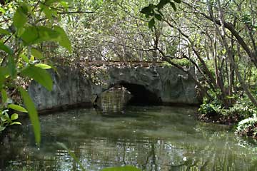
caption = Arch Creek natural limestone bridge was the site of early settlement in Miami-Dade county
location =Miami-Dade County, Florida , USA
nearest_city =North Miami, Florida
lat_degrees = 25
lat_minutes = 54
lat_seconds = 04
lat_direction = N
long_degrees = 80
long_minutes = 09
long_seconds = 41
long_direction = W
area =
established =July 15 ,1986
visitation_num =
visitation_year =
governing_body =Arch Creek was an early settlement in
Miami-Dade County, Florida , in present dayNorth Miami .Tequesta Indians thrived here before the first Europeans arrived in the early 16th century. The name is derived from the naturallimestone bridge spanning convert|40|ft|m across the creek. It is part of the Arch Creek Memorial Park at 1855 Northeast 135th Street, on Biscayne Boulevard. It was added to the U.S.National Register of Historic Places onJuly 15 ,1986 .History
During the
Seminole Wars , GeneralAbner Doubleday (often credited with inventingbaseball ) blazed a trail betweenFort Lauderdale andFort Dallas on the Miami River. This Military Trail crossed over the limestone bridge, traversing the fresh water creek flowing from theEverglades toBiscayne Bay . In 1895,Henry Flagler 's railroad reached Arch Creek as it expanded southward, bringing a steady stream of visitors and settlers, largely from east coast states.The first families to settle the area planted tomatoes and pineapples. A railroad depot was established in 1903. Soon after, a packing plant, a sawmill, a post office and a school were erected as the town began to grow. By 1910, the area was a popular place for tourists and community gatherings. The "shell house" sold souvenirs, postcards and refreshments. On weekends, families from many miles away would attend barbecues with as many as 500 people. "Dad" Wiggins, the self-proclaimed best barbecue chef in
Florida , would start slow-cooking large amounts of meat and families would bring baked goods, side dishes and desserts while kids played along the banks of the creek. By 1912, the community included eighteen homes, a church, a general store, a blacksmith shop, and two tomato packing houses. [http://www.northmiamifl.gov/COMMUNITY/history/]By 1920, the population of Arch Creek had grown to 307. The
Biscayne Canal was dug in 1924 to reduce flooding of farmland. During the Florida land boom of the 1920s, portions of the community were subdivided and sold to northern tourists as residential lots. On February 5, 1926, the incorporated Town of Miami Shores was established by a vote of 38 registered voters. A destructive hurricane in September 1926 brought land sales to a halt. However, proceeds of a $287,000 bond issue were used to build a new city hall in 1928. The Arch Creek school burned down in 1927 and was replaced in 1928 by the W.J. Bryan school, which is still in operation. [http://www.northmiamifl.gov/COMMUNITY/history/]The town kept the name of "Miami Shores" until 1931. In 1952 it was incorporated into the City of
North Miami .In 1957, the first of many threats against the future of the natural bridge materialized. The bridge was endangered by a plan to drain low lying areas as part of a flood prevention program. The
Army Corps of Engineers wanted to blow up the bridge, or re-route the creek. A 1957 newspaper article announced that "the bridge must be sacrificed for better drainage of the area." Protests from members of the localAudubon Society , the Historical Association of Southern Florida and the Dade Conservation Council prevented any of this destructive action.Things remained quiet until the 1970s, when Arch Creek became the property of the Chrysler Corporation. Their plans called for the construction of an automobile showroom, and a new and used car agency. In 1972, Chrysler requested a zoning change from the City of North Miami, which would have allowed them to pave the area and build a garage on the property. Vigorous opposition came from the Tropical Audubon Society, the Miami-West India Archaeological Society, the Keystone Point Homeowners' Association, and the members of the Arch Creek Trust. After almost a year, of intense lobbying the State of
Florida agreed to purchase the land for a state park. The State's Land Acquisition Trust allocated $822,000 to buy 7.9 acres of property east of the Creek.A group of local citizens, who later formed the organization Arch Creek Trust, went to
Tallahassee in February 1973, to finalize the agreement. On the night they returned, the natural bridge collapsed and fell into the creek. Rumors of sabotage ran through the community, and the Metro-Dade Police Bomb Squad was called out. Nothing was discovered, and experts generally agreed later that the fall was probably due to constant vibrations from passing trains, or erosion, or just old age and decay. In the years that followed, there were various efforts to restore the bridge, clear the property of trash and save additional land in the area.The porous oolitic (pronounced oh-a-li-tic) limestone bridge was laced with roots from the oak trees growing on both banks of the creek, and likely those roots were what was holding the rock together. A number of trees near both ends of the bridge were removed, thus killing the roots. Then in order to keep vehicular traffic from using the bridge it was blocked off by boring a row of large holes through the road at both ends of the bridge, and standing discarded wooden railroad ties in the holes. When the bridge collapsed it broke along the two rows of "perforations" drilled for the ties.Fact|date=June 2007
In 1978 Dade County leased the land from the State of
Florida and began making plans to turn it into a passive recreation facility. Clean-up crews appeared, and construction started on a small museum and nature study center. A nature trail was constructed in the hammock area by theYouth Conservation Corps . In addition, they planted over 500 trees. The Arch Creek Park was formally dedicated on April 25, 1982. Today, Arch Creek is an eight-acre site at the junction of N.E. 135th Street and Biscayne Boulevard, and offers many opportunities for botanical, historical and archaeological study. It has a museum/nature center modeled after an early Florida pioneer home, displaying Indian artifacts dug from the grounds, and live animals from the nearby hammock. Remains of the original coontie mill are still visible across the creek, and the Park exists as the only preserved archaeological site in the County.In 1992, Arch Creek Trust and the Trust for Public Lands worked to acquire an additional 1.5 acres at the northern end of the park, bringing the total size of the park to 9.4 acres. Funding was provided by the Environmentally Endangered Lands (EEL) Program. In 1994 the park received a grant to add a Butterfly Garden, on this new site, using native butterfly-attracting plants.
There is a year 'round program of activities at the park, ranging from lectures by environmentalists, historians and archaeologists to monthly films featuring environmental subjects. Guided trail walks are held every Saturday at 9:30am and many Dade County school children visit on a regular basis.
References
*"Arch Creek Trust Historical Notes" (by Arch Creek Trust members).
*"Biscayne Country" (by Thelma Peters 1981).
*"Burr Family History" (by Robert Adams Burr).External links
* [http://www.nationalregisterofhistoricplaces.com/FL/Dade/state.html Dade County listings] at [http://www.nationalregisterofhistoricplaces.com National Register of Historic Places]
* [http://www.flheritage.com/facts/reports/places/Counties/Dade.cfm Dade County listings] at [http://www.flheritage.com Florida's Office of Cultural and Historical Programs]
* [http://www.geocities.com/archcreek/ Arch Creek Trust web site]
* [http://www.miamidade.gov/parks/Parks/arch_creek.asp Arch Creek Park web site]
* [http://fcit.usf.edu/florida/photos/native/archck/archck.htm University of South Florida Arch Creek Gallery]
* [http://www.northmiamifl.gov/community/history/ City of North Miami History]
* [http://www.rootsweb.com/~srgp/articles/archcrk.htm Arch Creek settlers from Elmira, New York]
Wikimedia Foundation. 2010.