- Civic Center (Metrorail station)
-
Civic Center
Metrorail metro station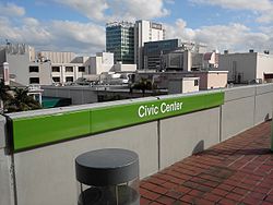
View from Civic Center station platformStation statistics Address 1501 NW 12th Avenue,
Miami, Florida 33136Coordinates 25°47′23″N 80°12′54″W / 25.78972°N 80.215°WCoordinates: 25°47′23″N 80°12′54″W / 25.78972°N 80.215°W Lines Connections  Metrobus
Platforms 2 side platforms Tracks 2 Other information Opened December 17, 1984 Accessible 
Code CVC Owned by Miami-Dade County Traffic Passengers (2010) 1.7 million[1]  0%
0%Services Preceding station Metrorail Following station toward PalmettoGreen Line toward Dadeland Southtoward AirportOrange Line (2012) Civic Center is a Metrorail station in the Civic Center Health District of Miami, Florida.
This station is located at the intersection of Northwest 12th Avenue (State Road 933) and 15th Street, opening to service December 17, 1984, and is one of the busiest Metrorail stations.
Contents
Places of interest
- Jackson Memorial Hospital
- University of Miami Miller School of Medicine
- Bascom Palmer Eye Institute
- Veterans Hospital
- Miami Ballpark
- Miami-Dade County Jail
- Miami-Dade Justice Building/Courts
- Florida State Building
- Cedars Medical Center
- Miami-Dade County Health Department
- University of Miami Hospitals and Clinics
Transit connections
Metrobus
Route # Route Name Route Map Note 12 Northside station ↔ Mercy Hospital via West 12 Ave Map 32 Carol City ↔ Omni at Adrienne Arsht station Map 95X Downtown Miami ↔ Golden Glades via I-95 Map Morning southbound and afternoon northbound only M (113) Civic Center at West 19 Avenue and North 20 Street ↔ Mount Sinai Medical Center & Miami Heart Institute Map 246 Night Owl (Downtown Miami ↔ The Mall at 163rd Street via West 22 Ave) Map Overnight service only References
External links
Categories:- Miami Metrorail stations
- Railway stations opened in 1984

Wikimedia Foundation. 2010.