- Florida State Road 886
-
State Road 886
Port Boulevard Route information Maintained by FDOT Length: 0.826 mi[1] (1.329 km) Existed: 1980[citation needed] – present Major junctions West end:  US 1 in Miami
East end: Port of Miami Location Counties: Miami-Dade Highway system Florida State and County Roads
Interstate • US • SR (Pre-1945) • Toll • County←  SR 884
SR 888  →
→State Road 886, also known as Port Boulevard, is a causeway connecting the Port of Miami with downtown Miami, Florida. Its western terminus is an intersection with U.S. Route 1 (Biscayne Boulevard) just north of Bayside Marketplace. It received its FDOT designation in 1980.
Contents
Route description
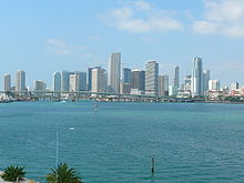 View of the Port Boulevard Bridge from the MacArthur Causeway Bridge; a partial view of the Downtown Miami skyline is in the background
State Road 886 begins where Port Boulevard and 6th Street intersect Biscayne Boulevard, which carries U.S. Route 1. Port and 6th are, for 400 feet (120 m), a couplet of one-way streets before they join as Port Boulevard. The road passes American Airlines Arena and ascends the approach of the Port Boulevard Bridge over Biscayne Bay. On the other side of the bridge, SR 886 ends at the entrance to the Port of Miami.[2]
History
Prior to the construction of the current high-level causeway to replace one with a drawbridge, a tunnel connecting the Port of Miami and Interstate 95 was contemplated as a replacement instead. Although the proposal failed to attract support from the City of Miami commission, a similar, more recent, proposal for a tunnel connecting the port with SR A1A on nearby Watson Island was eventually approved and on May 24, 2010, construction began on the Miami Port Tunnel.[3]
Junction list
The entire route is in Miami, Miami-Dade County.
Mile[1] Destinations Notes 0.000 US 1 (Biscayne Boulevard)Port Boulevard Bridge over Biscayne Bay 0.826 Port of Miami 1.000 mi = 1.609 km; 1.000 km = 0.621 mi See also
List of state highways in the United States shorter than one mile
References
- ^ a b Florida Department of Transportation. "Shapefiles of GIS Layers". http://www.dot.state.fl.us/planning/statistics/gis/road.shtm. Retrieved July 18, 2011.
- ^ Google, Inc. Google Maps – Florida State Road 886 (Map). Cartography by Google, Inc. http://maps.google.com/maps?saddr=S+American+Way&daddr=NE+6th+St%2FPort+Blvd+to:Biscayne+Blvd&hl=en&ll=25.778716,-80.182943&spn=0.01967,0.027251&sll=25.780716,-80.186259&sspn=0.004917,0.006813&geocode=FeNUiQEdvJY4-w%3BFdlfiQEdsW44-w%3BFVJfiQEd9Gk4-w&gl=us&mra=dme&mrsp=1&sz=17&t=h&z=15. Retrieved July 18, 2011.
- ^ Local 10. "Port Tunnel Construction Begins". Archived from the original on July 18, 2011. http://www.webcitation.org/60G8t2lTZ. Retrieved August 13, 2010.
Crossings of the Biscayne Bay North
MacArthur Causeway


Port Boulevard

South
Rickenbacker Causeway
 Categories:
- State highways in Florida
- State Roads in Miami-Dade County, Florida
- State Roads in Miami, Florida
- Intracoastal Waterway
- Port of Miami


Wikimedia Foundation. 2010.