- Florida State Road 836
-
State Road 836
Dolphin Expressway Route information Maintained by Miami-Dade Expressway Authority and FDOT Length: 18.9 mi (30.42 km)
14.081 mi. tollway sectionExisted: 1969 – present Major junctions West end: NW 137th Avenue in Tamiami 
 Homestead Ext / SR 821 near Tamiami
 SR 826 near Doral

 I-95 / SR 9A in Miami

 US 1 / SR 5 in Miami
East end:  SR A1A in in Miami Beach
Location Counties: Miami-Dade Highway system Florida State and County Roads
Interstate • US • SR (Pre-1945) • Toll • County←  ex-SR 835
ex-SR 837  →
→←  SR 394
SR 395  →
→State Road 836, locally known as the Dolphin Expressway, is a 19-mile-long six-lane divided expressway, with the westernmost 14 miles being a tollway, currently extending from just north of the intersection of Southwest 137th Avenue and U.S. Route 41 (SR 90) in Tamiami, eastward past the Homestead Extension of Florida's Turnpike (SR 821) and Miami International Airport, before intersecting I-95 and ceasing to be a toll road. A 1.29 mile section of SR 836 between I-95 and US 1 is signed Interstate 395, with SR 836 continuing unsigned, passing through US 1 (SR 5) before ending at SR A1A in Miami Beach.[1] It is maintained and operated by the Miami-Dade Expressway Authority.
Contents
Route description
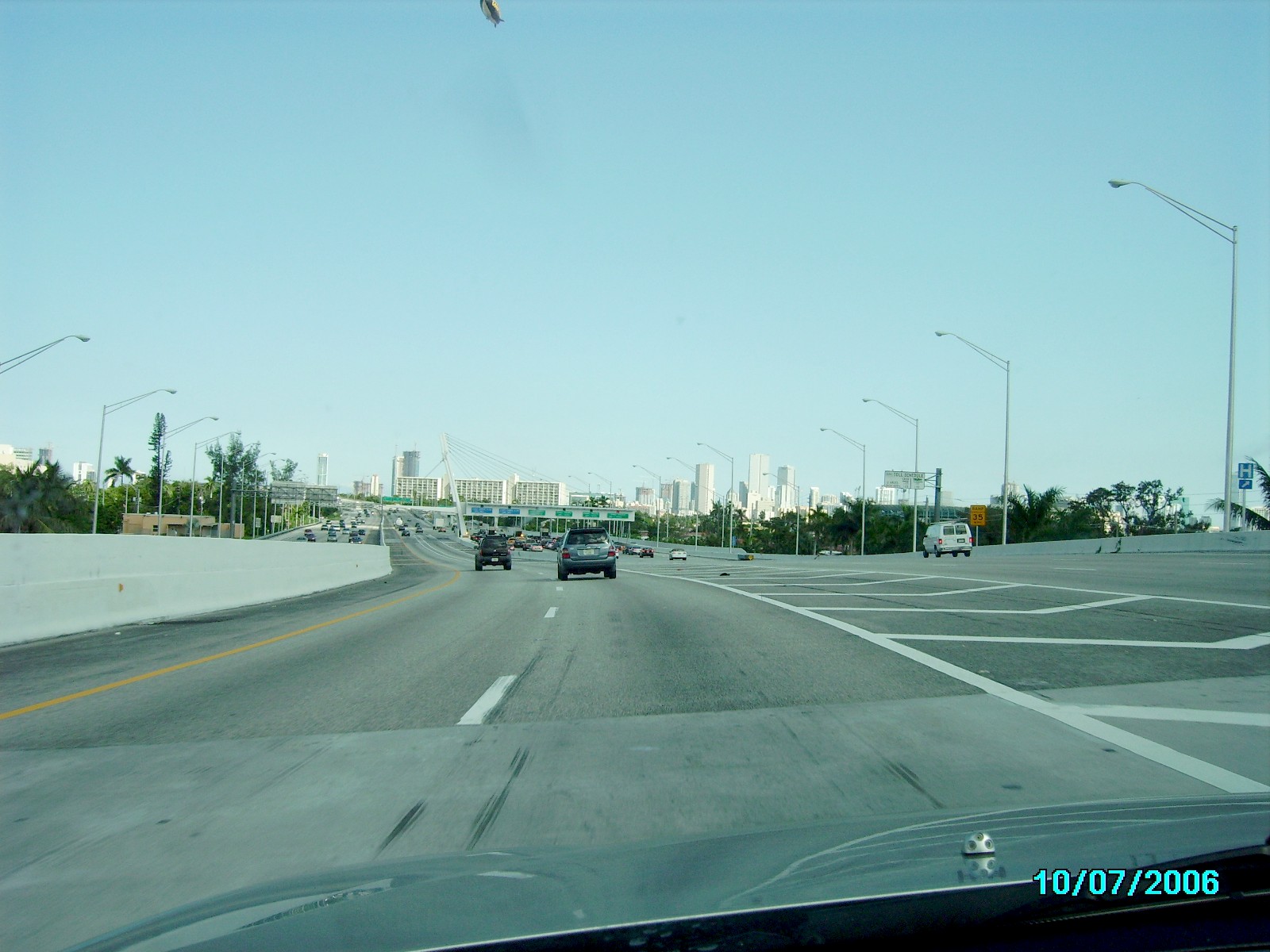
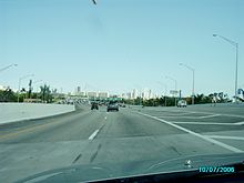 Dolphin Expressway (SR 836) eastbound with downtown Miami in the distance
The highway begins just north of the intersection of Southwest 137th Avenue and U.S. Route 41 (SR 90) in Tamiami, as a SunPass only section of the expressway, built in 2007 and accessible only to motorists with SunPass transponders. The expressway heads east towards the Homestead Extension of the Turnpike, and then passes through the first of two toll barriers. It then intersects with the Palmetto Expressway (SR 826), and passes through the southern end of the Miami International Airport. With the failure of the Florida Department of Transportation to build either the previously-planned airport spur or the proposed LeJeune Road Expressway to give additional access to the airport, Miami-Dade County's sole complete east–west throughway is now often congested, most commonly in the stretch between the Palmetto Expressway (SR 826) and LeJeune Road (SR 953). East of the interchange with the airport at LeJeune Road, eastbound lanes pass through a second toll barrier just west of downtown. The highway has two more interchanges in the fringes of downtown before intersecting with I-95 and becoming a free road and unsigned as I-395 goes into downtown Miami. East of US 1, SR 836 continues unsigned, crossing the MacArthur Causeway to its end at SR A1A in Miami Beach.[citation needed][2]
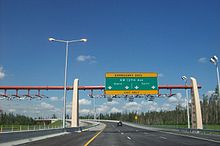 Signage denoting the current western terminus of the Dolphin Expressway, also serving as an exclusive SunPass toll plaza
Until July 1, 2007, the toll for eastbound automobiles was $1.25 ($1.00 for motorists with SunPass), paid at a toll booth between Northwest 22nd and Northwest 17th Avenues (toll is not collected from westbound traffic). In conjunction with the completion of the new three-mile-long extension west of the Turnpike, tolls of $1.00 (75 cents for motorists with SunPass) are now collected from traffic in both directions west of SR 973 (Northwest 87th Avenue/Galloway Road). Although the new toll was originally stated to be only for the extension, motorists going to the Florida Turnpike or Northwest 107th Avenue also have to pay.[3] Thus, the total toll for eastbound traffic traveling along the expressway from the Turnpike to Interstate 95 is now $2.25 (or $1.75 for motorists with SunPass). Traffic traveling the new SunPass-only extension to/from Northwest 137th Avenue pays an additional 25 cents.
History
Originally envisioned as the Twentieth Street Tollway in 1964 (with a spur to the airport along LeJeune Road), construction on the Fourteenth Street east–west Expressway between the Palmetto Expressway and US 1 started in 1967 and was completed in 1969. Two years later, construction of the western extension to Florida's Turnpike commenced, and was finished in 1974. Also in 1974, the name of the tollway was changed to commemorate the success of the Miami Dolphins of the NFL, after back-to-back wins in the Super Bowl.
Construction of a second westward extension of SR 836 started in 2004.[4] This extension, westward to Northwest 137th Avenue near Northwest 12th Street, opened June 22, 2007, accessible only to motorists with SunPass electronic toll-paying capability; there is no capacity for the collection of cash.
Future
Short range plans include the construction of additional lanes and a redesign of a heavily-used interchange with SR 826.[5] A planned third extension (southward to Southwest 136th Street) is currently being considered.[citation needed]
The Dolphin Expressway is planned to be converted to open road tolling in the next few years, along with the other expressways on MDX.[6]
On May 24, 2010, construction began on the Miami Port Tunnel, a $1 billion project that will connect the port to other major highway arteries, including I-395, with the tunnel expected to be completed in 2015.[7]
Exit list
The entire route is in Miami-Dade County.
Location Mile[8] Destinations Notes Tamiami 0.000 Northwest 137th Avenue Westbound exit and eastbound entrance 3.279 Homestead Ext – Homestead, Key West, Ft. Lauderdale, OrlandoWestbound exit and eastbound entrance Doral 3.570  SR 985 (Northwest 107th Avenue)
Westbound exit and eastbound entrance (other access is only to/from Turnpike) Toll plaza ($1.00, $.75 with SunPass) 5.594  SR 973 (Northwest 87th Avenue, Galloway Road) / Northwest 12th Street
6.581 

 SR 826 (Palmetto Expressway) to US 41 (Tamiami Trail) / SR 968 (Flagler Street/Coral Way) / SR 948 (Northwest 36th Street)
7.113  SR 969 (Northwest 72nd Avenue, Milam Dairy Road)
8.675  SR 959 (Red Road) – Coral Gables
Miami Northwest 45th Avenue Eastbound exit and westbound entrance 10.261  SR 953 (Northwest 42nd Avenue, Le Jeune Road) – Coral Gables, Miami International Airport
10.781 Northwest 37th Avenue – Miami International Airport Westbound exit and eastbound entrance 11.820  SR 9 (Northwest 27th Avenue)
Toll plaza ($1.25 eastbound only, $1.00 with SunPass) 12.901 Northwest 17th Avenue – Miami Ballpark, Civic Center, Hospitals Eastbound exit and westbound entrance, Exit 0A 13.433  SR 933 (Northwest 12th Avenue) – Medical Center, Civic Center
Westbound exit and eastbound entrance, Exit 0B 13.701 Northwest 12th Avenue Exit 0C 14.081 I-95 / SR 9A – Ft. Lauderdale, Downtown MiamiWestern terminus of I-395, end tolls eastbound; signed as exits 1A (south) and 1B (north) westbound 15.142 US 1 / SR 5 (Biscayne Boulevard) / Northeast 2nd Avenue – ArenasSigned as exit 2B eastbound; exit 2A westbound 15.373 SR A1A north – Miami BeachEastern terminus of I-395; western end of SR A1A concurrency MacArthur Causeway over Biscayne Bay Miami Beach SR A1A north (Collins Avenue)Eastern terminus, eastern end of SR A1A concurrency References
- ^ "Route Log and Finder List - Interstate System: Table 2". FHWA. http://www.fhwa.dot.gov/reports/routefinder/table2.cfm. Retrieved 2007-10-03.
- ^ Google, Inc. Google Maps – overview map of SR 836 (Map). Cartography by Google, Inc. http://maps.google.com/maps?f=d&source=s_d&saddr=Unknown+road&daddr=5th+St%2FFlorida+A1A+N&hl=en&geocode=FY1RiQEdd-00-w%3BFXxJiQEdtD85-w&mra=ls&sll=25.776784,-80.41607&sspn=0.004647,0.006899&ie=UTF8&t=h&z=11. Retrieved 2010-05-09.
- ^ "MDX Frequently Asked Questions (FAQs)". Miami-Dade Expressway Authority. http://www.mdx-way.com/faqs/. Retrieved 2008-06-13.[dead link]
- ^ "Miami-Dade Expressway Authority Five-Year Work Program" (PDF). Miami-Dade Expressway Authority. Archived from the original on 2008-04-11. http://web.archive.org/web/20080411004139/http://www.mdxway.com/improvements/docs/Transportation_Improvement.pdf. Retrieved 2008-06-13.
- ^ 826-836 Access. Mobility. Progress.
- ^ Chardy, Alfonso. "Cash tolls on Miami-Dade expressways will soon be electronic". Miami Herald 23 Mar 2010.
- ^ Transportation Improvement Program Fiscal Years 2010/2011 to 2014/2015
- ^ Florida Department of Transportation. "FDOT Interchange Report" (PDF). http://www.dot.state.fl.us/planning/statistics/hwydata/interchange.pdf. Retrieved October 4, 2007.
External links
Auxiliary routes of Interstate 95 Florida: 195 • 295 • 395 • 595 • 795 (future) — North Carolina: 295 (future) • 795 — Virginia: 195 • 295 • 395 • 495 • 595 (former) • 895 (proposed) — District of Columbia: 295 • 395 • 495 • 695 (unsigned) — Maryland: 195 • 295 • 395 • 495 • 595 (unsigned) • 695 • 795 • 895 — Delaware: 295 • 495 • 895 (former) — Pennsylvania: 195 (future) • 695 (unbuilt) • 895 (unbuilt) — New Jersey: 195 • 295 • 495 (former) • 695 (unbuilt) • 895 (unbuilt) — New York: 295 • 495 • 695 • 895 — Connecticut - Rhode Island - Massachusetts: 195 • 295 • 395 • 495 • 695 (unbuilt) • 895 (unbuilt) — Maine: 195 • 295 • 395 • 495
Expressways in South Florida Florida Department of Transportation Miami-Dade Expressway Authority Airport Expressway (SR 112) • Dolphin Expressway (SR 836) • Don Shula Expressway (SR 874) • Snapper Creek Expressway (SR 878) • Gratigny Parkway (SR 924)
Florida's Turnpike Enterprise Notable bridges and tunnels in Florida Panhandle Escambia Bay · Garcon Point · John Gorrie · Mid-Bay · Pensacola Bay · St. George Island · Trammell · Victory
North Acosta · Bridge of Lions · Buckman · Dames Point · Fuller Warren · Hart · Mathews · Memorial · Strauss Trunnion
West Central East Central A. Max Brewer · Bennett Causeway · Bert Dosh · Broadway · Eau Gallie Causeway · Granada · Melbourne Causeway · Merritt Island Causeway · NASA Causeway · Pineda Causeway · Port Orange Causeway · Roosevelt · Wabasso
South Broad Causeway · Cape Coral · Coral Springs† · Julia Tuttle Causeway · John F. Kennedy Causeway · John Ringling Causeway · Lehman Causeway · MacArthur Causeway · Matanzas Pass · Midpoint · Rickenbacker Causeway · Sanibel Causeway · Snow-Reed‡ · Venetian Causeway
Keys Bahia Honda · Card Sound · Jewfish Creek · Overseas Highway · Seven Mile
Tunnels † – Covered bridge‡ - Swing bridge
See also: List of bridges in FloridaCrossings of the Biscayne Bay North
Venetian CausewayMacArthur Causeway
South
Port Boulevard
 Categories:
- State highways in Florida
- State Roads in Miami, Florida
- Toll roads in Florida
- State Roads in Miami-Dade County, Florida
- Freeways in the United States
- Intracoastal Waterway


Wikimedia Foundation. 2010.