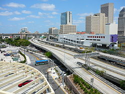
- Florida State Road 970
-
State Road 970 Downtown Distributor Route information Maintained by FDOT Length: 0.563 mi[1] (0.906 km) Existed: 1968 – present Major junctions West end:  I-95 in Downtown Miami
East end:  US 1 (Biscayne Boulevard) / SE 2nd Avenue in Downtown Miami[2]
Location Counties: Miami-Dade Highway system Florida State and County Roads
Interstate • US • SR (Pre-1945) • Toll • County←  SR 969
SR 972  →
→State Road 970, also known as the Downtown Distributor,[2] is a short 0.6-mile (0.97 km) elevated freeway connecting Interstate 95 and U.S. Route 1 in Downtown Miami.
Contents
Route description
The expressway is two lanes wide in each direction, and had an annual average daily traffic volume of 34,000 according to a 2007 report, with an estimated volume of 37,500 in 2015.[3]
In addition to the entrance and exit at US 1, SR 970 also has entrance and exit ramps at Miami Avenue, three blocks to the west. Eastbound drivers also can exit to SE 1st Avenue near the James L. Knight Center and the Miami Tower.
This route is unsigned. On the Interstate, there is no recognition of the State Road status of the Downtown Distributor, as exit signs in both directions indicate "Biscayne Boulevard, US 1". On the Distributor, both at the eastern end and roughly 0.2-mile (0.32 km) from the Interstate, State Road 970 shields are present, but without directional indicators.
History
It opened simultaneously with the adjacent stretch of I-95 in 1968.
Exit list
Mile Destinations Notes 0.000  I-95
I-95Westbound exit and eastbound entrance Miami Avenue Eastbound exit (from I-95 south ramp) and westbound entrance SE 1st Avenue Eastbound exit 0.563  US 1 (Biscayne Boulevard), SE 2nd Avenue
Eastbound exit and westbound entrance See also
References
- ^ "Federal Aid Road Report". Florida Department of Transportation. October 1, 2010. http://www.dot.state.fl.us/planning/statistics/fedaid/fedaidrpt.xlsx. Retrieved October 30, 2010.
- ^ a b "Access Management Class Summary: FDOT District VI - Miami-Dade County" (PDF). Florida Department of Transportation. September 8, 2009. p. 1. http://www2.dot.state.fl.us/fdotd6erc/SFilesDisplay.aspx?FID=900. Retrieved 2009-09-16.
- ^ "Arterial Grid Analysis Study". Miami-Dade County Metropolitan Planning Organization. March 2007. p. 88. http://www.miamidade.gov/mpo/docs/MPO_arterial_grid_analysis_final_200703.pdf. Retrieved 2009-09-16.
Expressways in South Florida Florida Department of Transportation Miami-Dade Expressway Authority Florida's Turnpike Enterprise Categories:- State highways in Florida
- State Roads in Miami-Dade County, Florida
- State Roads in Miami, Florida
Wikimedia Foundation. 2010.


