- Florida State Road 826
-
State Road 826
Palmetto Expressway Route information Maintained by FDOT Length: 29.938 mi[1][2] (48.181 km)
24.71 miles (39.77 km) expressway sectionExisted: June 1961 (freeway) – present Major junctions South end: 
 US 1 / SR 5 in Pinecrest
 SR 874 near Kendall
 SR 836 near Doral


 I-75 / SR 93 / SR 924 in Hialeah


 I-95 / SR 9 / SR 9A in Miami Gardens

 Turnpike / SR 91 in Miami Gardens

 US 441 / SR 7 in Miami Gardens
US 1 / SR 5 in North Miami BeachNorth end:  SR A1A in Sunny Isles Beach
Location Counties: Miami-Dade Highway system Florida State and County Roads
Interstate • US • SR (Pre-1945) • Toll • County←  SR 825
SR 827  →
→State Road 826, also known as the Palmetto Expressway, is a bypass route around the greater Miami area, extending 24.7 miles (39.8 km) from U.S. Route 1 (SR 5) in Pinecrest, going through the inner Miami suburbs in a north-east semicircle to the Golden Glades Interchange, reverting to a surface street (Northeast 163rd Street) to its terminus at Florida State Road A1A in Sunny Isles Beach. Interstate 95 (SR 9 and 9A) and the Palmetto Expressway are the two most-heavily traveled roads in Miami-Dade County.[citation needed]
Contents
Route description
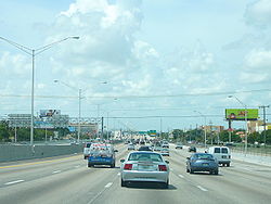 The Palmetto Expressway northbound near Hialeah in metropolitan Miami
The expressway begins on an intersection with US 1 in Pinecrest, just south of Dadeland Mall. The road heads north into Kendall, with the first interchange being with Kendall Drive, providing access to the mall. It continues north, crossing under the Snapper Creek Expressway before an interchange with SR 986. It leaves Kendall, continuing into Glenvar Heights, with an interchange with SW 56th Street/Miller Drive, which provides access to the University of Miami. It is followed by the northern terminus of the Don Shula Expressway, with a southbound exit and a northbound entrance point. It continues north into Coral Way Village, where it interchanges with SR 976, followed shortly with an exit with SW 24th Street/Coral Way.
The expressway's next exit to the north is with Tamiami Trail (US 41), providing access to Florida International University. The Palmetto then has an exit with Flagler Street, the east-west median for Miami-Dade County roads. The freeway then has an interchange with the Dolphin Expressway just south of Doral, creating access to Miami International Airport. This interchange is currently being improved due to the current configuration causing severe congestion. The next exit is NW 25th Street, which connects to the western end of the airport, followed by an exit with SR 948, that links to the Doral Golf Resort and Spa, and then an exit with NW 58th Street. Heading north, the expressway reaches an interchange with SR 934 that goes into Medley, followed by a diagonal interchange with US 27/SR 25 at the southern end of Hialeah Gardens and Hialeah. It then enters Hialeah, with an interchange with SR 932, accessing Westland Mall, followed by an exit with NW 122nd Street.
At the boundary between Hialeah and Miami Lakes, there is an interchange between the national southern terminus of I-75 and the western terminus of SR 924. The Palmetto Expressway goes into Miami Lakes, with an interchange with NW 154 Street, followed by a 90 degree turn, with the road going straight east, still in Miami Lakes, with an interchange with NW 67th Avenue. At the next exit, SR 823, the expressway enters Miami Gardens, with the next exit being SR 847. The expressway then passes through Florida Memorial University before the NW 37th Avenue exit, where it creates the northeast border with St. Thomas University.
Still in Miami Gardens, it has exits with SR 817, NW 17th Avenue and NW 12th Avenue before the Golden Glades Interchange, where it intersects with Florida's Turnpike, I-95 and US 441/SR 7. After the interchange, it reverts to a surface street (Northeast 167th Street), entering North Miami Beach, intersecting with SR 915, curving to the southeast to become NE 163rd Street, meeting the Mall at 163rd Street, US 1, crossing the Intracoastal Waterway before ending at SR A1A in Sunny Isles Beach.[3][4]
History

State Road 826's designation originally applied to a two-lane road (Golden Glades Drive, Northwest 167th Street) connecting US-1 in North Miami Beach to US 27 (SR 25) to the west. In 1953, the newly-formed Florida Turnpike Authority presented plans for a four-lane bypass highway going around the Miami area.
In 1956, plans were unveiled for several expressways throughout Dade County. The routes proposed were a North-South Expressway (now part of I-95), an East-West Expressway (now the Dolphin Expressway), a 36th Street Expressway (now the Airport Expressway), the Biscayne Bay Malecon (a proposed downtown loop, never built), a Dixie Expressway (proposed; most was never built, a portion became I-95), and the Palmetto Road Expressway.[5]
In 1957, Dade County Commissioner Ralph Fossey proposed an alternate alignment of the Palmetto Expressway. The new alignment would begin at Miller Road (SW 56 Street) and then turn southwesterly to follow the Seaboard Railroad tracks for about 10 miles. The route would then turn south at SW 117 Ave. and follow it into US 1.[6]
Many south Miamians opposed the alternate alignment plan and began a petition to keep the original alignment. While the alternate route plan ultimately failed; eventually the Don Shula Expressway, a northeast-southwest expressway was built along the railroad tracks in the 1970s.
In 1958, the Florida State Roads Department started construction on the bypass expressway under their authority.[7] A north–south section along Northwest (and Southwest) 77th Avenue (Palmetto Road) was built to connect US 1 in Pinecrest to an improved Golden Glades Drive (complete with 90 degree eastward turn) and the portion of Northwest 167th Street west of the curve would be abandoned. Many land owners were forced to sell their property to the county to make way for the construction of the expressway.[8]
The Palmetto Bypass Expressway was opened in June 1961 at the cost of $30 million, four years after the opening of Florida's Turnpike and six months before the opening of Dade County's second expressway, the Airport Expressway (SR 112).[9][10]
The completion of the Palmetto Expressway (the "Bypass" faded from public usage in the 1960s) and the building of Interstate 95 were the impetus of the construction of the massive Golden Glades Interchange involving Florida's Turnpike, US 441 (SR 7), Interstate 95, and SR 9.
When the Palmetto Expressway was first opened, it went through tracts of woodland and farmland which have since been urbanized. Originally there were four at-grade intersections in Hialeah and Miami Lakes which were either transformed into full interchanges or blocked off in the 1970s. In addition, increasing traffic loads on the Palmetto prompted plans for extending Florida's Turnpike to "bypass the bypass." In 1974, the Homestead Extension of Florida's Turnpike (SR 821) was opened to traffic four miles (6 km) to the west of the Palmetto to reduce the traffic demands on Miami's original bypass.
Future
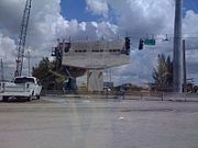 A new overpass under construction at Miller Drive to alleviate congestion at the Bird Road exit
The Florida Department of Transportation is currently in the final stages of improving a 16.7 mile section of the expressway from the southern terminus to just north of the Northwest 154th street interchange, widening the highway by two lanes (from 8-10 lanes to 10-12 lanes), and improving the interchanges. Reconstruction of the Miller Drive and SR 976 (Bird Road) interchanges, including the Don Shula Expressway (State Road 874) interchange, began in 2008, and is scheduled to be completed in 2012. The Dolphin Expressway interchange construction began on November 30, 2009 and will be completed in 2015.[11][12]
Exit list
The entire route is located in Miami-Dade County.
Location Mile[1][2] Destinations Notes Pinecrest 0.000 US 1 / SR 5 (South Dixie Highway)Southern terminus Kendall 0.858  SR 94 (Kendall Drive)
1.857  SR 986 (Sunset Drive)
2.876 SW 56th St, Miller Drive To University of Miami 3.432 SR 874 (Don Shula Expressway)Southbound exit and northbound entrance 3.932  SR 976 (Bird Road)
4.984 SW 24th St, Coral Way To Florida International University 5.977 
 US 41 / SR 90 (SW 8th Street/Tamiami Trail)
6.491  SR 968 (W Flagler Street)
7.230 SR 836 (Dolphin Expressway)To Miami International Airport Doral 8.372 NW 25th Street To Miami International Airport 9.216  SR 948 (NW 36th Street)
10.381 NW 58th Street Medley 11.383  SR 934 (NW 74th Street)
Hialeah Gardens 12.310 
 US 27 (S River Drive / Okeechobee Road) / SR 25
13.173  SR 932 (NW 103rd Street / W 49th Street)
Hialeah 14.374 NW 122nd Street, W 68th Street 15.379 I-75 / SR 93 north – Naples
Miami Lakes 16.393 NW 154th Street 18.006 NW 67th Avenue 19.016  SR 823 (NW 57th Avenue)
Miami Gardens 20.047  SR 847 (NW 47th Avenue)
21.048 NW 37th Avenue 22.052  SR 817 (NW 27th Avenue)
23.060 NW 17th Avenue 23.485 NW 12th Avenue 24.097 I-95 / SR 9 / SR 9A / Turnpike – Miami, Ft. Lauderdale, OrlandoPart of Golden Glades Interchange 24.236 Turnpike / SR 91 – OrlandoPart of Golden Glades Interchange 24.708 US 441 / SR 7Part of Golden Glades Interchange Palmetto Expressway ends, becomes North Miami Beach Boulevard North Miami Beach 25.708  SR 915 (NE 6th Avenue)
27.918 US 1 (Biscayne Boulevard) / SR 5North Miami Beach Boulevard ends, becomes Sunny Isles Boulevard Sunny Isles Beach 29.938 SR A1A (NW 57th Avenue)Northern terminus References
- ^ a b Google Inc. (July 8, 2008). Google Earth (4.3.7284.3916) [beta]. Retrieved July 30, 2009. <http://earth.google.com/>
- ^ a b "Florida Department of Transportation Interchange Report" (PDF). Florida Department of Transportation. 2008-11-24. pp. 15. http://www.dot.state.fl.us/planning/statistics/hwydata/interchange.pdf. Retrieved 2009-07-27.
- ^ Google, Inc. Google Maps – overview map of Palmetto Expressway (Map). Cartography by Google, Inc. http://maps.google.com/maps?f=d&source=s_d&saddr=Pinecrest+Pkwy&daddr=25.917765,-80.325025+to:Sunny+Isles+Blvd&geocode=FQDNhwEd5G82-w%3BFUV5iwEdX1Y2-yklzW9k16TZiDFBbWNuxHjdlg%3BFYuoiwEdaW85-w&hl=en&mra=ls&dirflg=t&sll=25.913431,-80.198822&sspn=0.074267,0.110378&ie=UTF8&t=h&z=11&via=1. Retrieved 2010-04-22.
- ^ Florida Department of Transportation (April 2007). General Highway Map Miami-Dade County, Florida (Map). http://www.dot.state.fl.us/surveyingandmapping/geomap/mida_c.pdf. Retrieved 2010-06-25.
- ^ "Questions on Expressway? - Here Are Some Answers". The Miami News 19 Dec 1956: 21A. Retrieved 16 April 2010
- ^ "Dispute On By-Pass Blocks Work Start". The Miami News 20 Apr 1957: 8A. Retrieved 16 April 2010
- ^ "Florida Pushes Road Improvements". New York Times 08 Dec 1957: XX13
- ^ "Palmetto Road Suit Enters Final Stages". The Miami News 3 Mar 1957: 22A. Retrieved on 16 April 2010
- ^ "Florida's New Palmetto Expressway". New York Times 18 Jun 1961: XX23
- ^ "Miami's Highways Set". The Evening Independent 16 Jun 1961: 2
- ^ "Palmetto Expressway Expansion Project" (PDF). Florida Department of Transportation. 2009-06-15. http://fdotpalmetto.com/pdf/Palmetto%20Expressway%20Project%20Overview.pdf. Retrieved 2009-07-27.
- ^ "Palmetto/Okeechobee: Project Information". http://fdotpalmetto.com/project.html. Retrieved 2009-07-27.
External links
Expressways in South Florida Florida Department of Transportation Miami-Dade Expressway Authority Florida's Turnpike Enterprise Categories:- State highways in Florida
- State Roads in Miami-Dade County, Florida
- Miami Gardens, Florida
- North Miami Beach, Florida


Wikimedia Foundation. 2010.