- Merritt Island Causeway
-
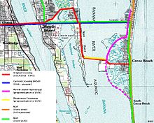 Cocoa - Merritt Island - Cocoa Beach current and former road alignments
The Merritt Island Causeway, which connects Cocoa, Florida, Merritt Island, Florida and Cocoa Beach, Florida, is the second route over the Indian River Lagoon and Banana River. The causeway divides Merritt Island into eastern and western sections. The western section is the location of the Hubert H. Humphrey Bridge, under which the Intracoastal Waterway passes. The eastern section is the location of the Willard Peebles bridge over the Banana River Lagoon. In the 1960s, SR A1A was routed over the eastern causeway from present day SR 520 and SR A1A, to the present day intersection of SR 520 and SR 3 on Merritt Island. The eastern section is known as the Cocoa Beach Causeway.
First route
On May 1, 1917, the first bridge opened between Cocoa, Florida and Merritt Island, Florida across the Indian River. Soon after this bridge was built, an idea for a new bridge connecting Merritt Island and Cocoa Beach over the Banana River began circulating. Eventually two routes were proposed, one each from a Mr. Barlow, and Mr. Rogers.
- Barlow's Route
- Cross over Sykes Creek and east to Cocoa Beach
- Roger's Route
- Cross from Horti Point east to Cocoa Beach.
On September 27, 1919, Roger's Route was approved. The bridge was finally completed April 19, 1922 after running into financial problems and costing an additional $200,000.
The present day alignment, from west to east, based upon this description
- Hubert H. Humphrey Bridge
- Palmetto Avenue (used to intersect at SR 520 and SR 3)
- East Merritt Island Avenue
- Audubon Road
- Old Audubon Road
- Triangle Road
- North Banana Drive (follow south to the start of the bridge)
The narrow lane draw bridge crossed the Banana River near Old Causeway Road on Horti Point. The present day Minuteman Causeway Boulevard in Cocoa Beach, and Old Causeway Road in Angel City are the remaining ends of the Merritt Island Causeway. The bridge system composed of the Indian River Bridge and the Banana River Bridge lasted another 18 years, when growth finally caught up with the bridge system.
Second route
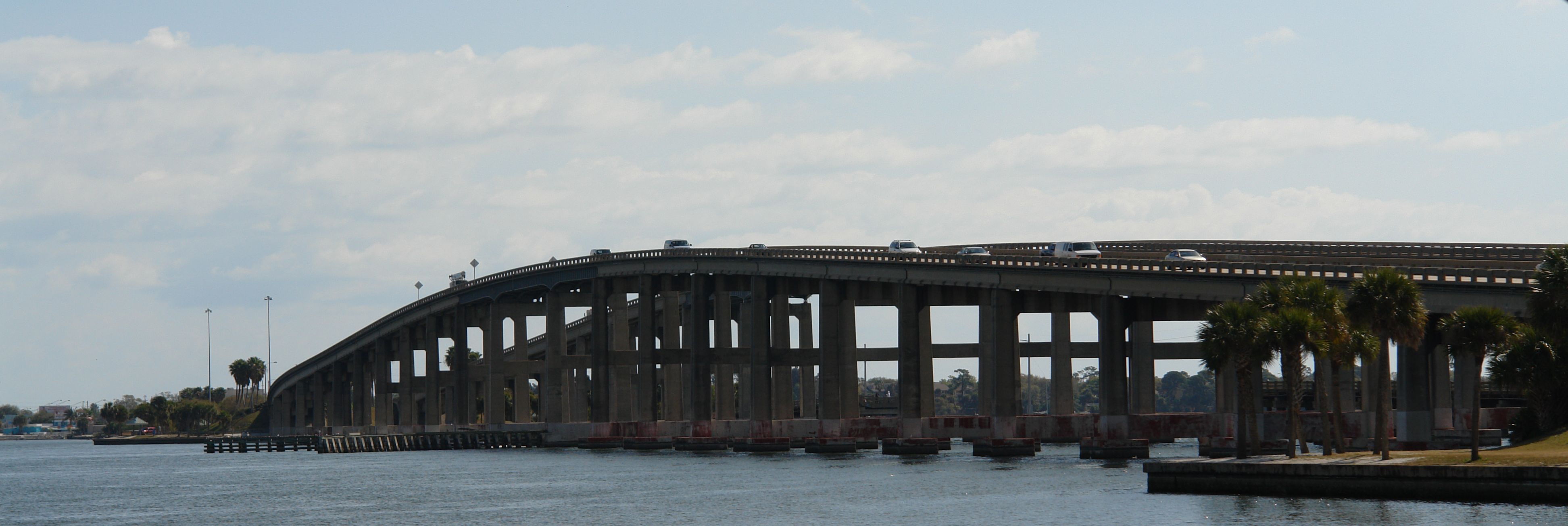
 The Hubert H. Humphrey Bridge connects Merritt Island and Cocoa.
On June 5, 1941, the present day alignment of SR 520 opened with a single wider lane in each direction. Two draw bridges, one on each river, and a few relief bridges made up the causeway. The original wooden bridges were torn up shortly afterwards. Today, the name Banana River Bridge refers to the eastern causeway of the Emory L. Bennett Causeway, a part of SR 528.
Traffic problems were growing worse in the 1960s, and the county appealed to then Vice President Hubert H. Humphrey for relief. Vice President spoke to NASA and the U.S. Air Force and they agreed to help fund the widening. On August 16, 1962, the road widening was completed. Less than six years later the Hubert H. Humphrey Bridge was dedicated by Hubert H. Humphrey on March 1, 1968.
At nearly the same time there were proposals for additional bridges in the area. Cocoa Avenue (now Minuteman Causeway) was proposed to cross to Merritt Island over the Minuteman Causeway. Its route would have taken it along the old Banana River Bridge. The idea was formally denied on February 26, 1970 by the State of Florida.
Widening projects continue, and the eastern draw bridge has been removed from the causeway.
References
- Brevard Property Appraiser Plat Book 3, Page 11
- Brevard Property Appraiser Plat Book 16, Page 142
- Brevard Property Appraiser Plat Book 21, Page 9
- The City of Cocoa Beach : The First Sixty Years. Glenn Rabac. Apollo Books. 1986 (Majority of facts from here)
- Kennedy Space Center History - Chapter 18
- Cocoa Village important dates in Cocoa History
- See the Talk:SR A1A article on references for SR A1A alignment
- Cocoa Beach Resolution 65-8
Notable bridges and tunnels in Florida Panhandle Escambia Bay · Garcon Point · John Gorrie · Mid-Bay · Pensacola Bay · St. George Island · Trammell · Victory
North Acosta · Bridge of Lions · Buckman · Dames Point · Fuller Warren · Hart · Mathews · Memorial · Strauss Trunnion
West Central East Central A. Max Brewer · Bennett Causeway · Bert Dosh · Broadway · Eau Gallie Causeway · Granada · Melbourne Causeway · Merritt Island Causeway · NASA Causeway · Pineda Causeway · Port Orange Causeway · Roosevelt · Wabasso
South Broad Causeway · Cape Coral · Coral Springs† · Julia Tuttle Causeway · John F. Kennedy Causeway · John Ringling Causeway · Lehman Causeway · MacArthur Causeway · Matanzas Pass · Midpoint · Rickenbacker Causeway · Sanibel Causeway · Snow-Reed‡ · Venetian Causeway
Keys Bahia Honda · Card Sound · Jewfish Creek · Overseas Highway · Seven Mile
Tunnels † – Covered bridge‡ - Swing bridge
See also: List of bridges in FloridaCategories:- Bridges in Brevard County, Florida
- Intracoastal Waterway
- Road bridges in Florida

Wikimedia Foundation. 2010.