- Northwest Province
Geobox|Province
name = Northwest Province
country = Cameroon
country_
capital = Bamenda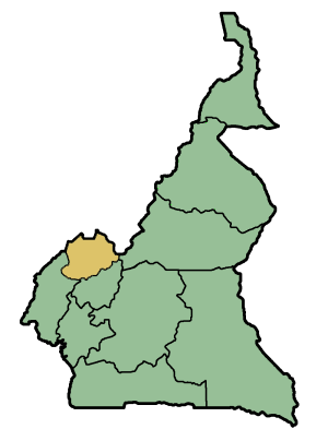
map_caption = Location of Northwest Province within Cameroon
coordinates_type = adm1st
lat_d = 6 |lat_m = 20 |lat_NS = N
long_d = 10 |long_m = 30 |long_EW = E
area = 17812
population = 1237348
population_as_of = 1987
population_density = auto
population_density_note = (2nd)
leader_type = Governor
leader = Issa Koumpa
part_type = Divisions
part = Bui
part1 = Boyo
part2 = Donga-Mantung
part3 = Menchum
part4 = Mezam
part5 = Momo
part6 = NgoketunjiaThe North-West Province (in French: "Province du Nord-Ouest") is found in the western highlands ofCameroon . It lies between latitudes 5° 40’ and 7° to the North of the equator, and between longitudes 9°45 and 11°10’ to the East of the Meridian. It is bordered to the south-west by theSouth-West Province , to the south by West Province, to the east byAdamawa Province , and to the north by theFederal Republic of Nigeria .The Northwest Province is the third most populated province in Cameroon. It has one major metropolitan city: Bamenda with several other smaller towns such as
Kumbo ,Mbengwi ,Nkambe ,Batibo . The province saw an increase in its population from about 1.2 million in 1987, to an estimated 1.8 million people in 2001. The population density, at 99.12 people per square kilometre, is higher than the national average of 22.6 people per square kilometre. The provincial urban growth rate is 7.95% (compared to the national average of 5.6%), while the rural growth rate, at 1.16%, is equal to the national rate. According to the "Statistical Provincial Services" of North-West Province in 2001, the population of the province is largely a young one, with over 62% of its residents aged less than 20 years. The dependency rate is therefore high in the province, particularly in the rural areas.Like other provinces in Cameroon, the North-West Province is made up of administrative divisions. The province was created in 1972 with five divisions: Mezam, Bui, Momo, Donga-Mantung, and Menchum. Today, it has seven divisions; the new ones are Ngoketunjia (carved out of Mezam Division) and Boyo (carved out of the Donga-Mantung Division). Each division is made up of subdivisions. There are thirty-one subdivisions in the North-West Province. The basic unit of local government, however, is the council; there are thirty-two councils in the province.The population of the North-West Province is a conglomerate of many ethnic groups, comprising the native population and a significant proportion of immigrants from other provinces and from foreign countries, particularly Nigeria, with whom the province shares boundaries in the North and North-West. The native population comprises a variety of ethnolinguistic groups. However, the main ethnic groups are: Tikari, Widikum, Fulani. The main languages spoken in the province include
Bafmen ,Oku ,Lamnso ,Ngemba ,Pigin English ,Balikumbat , andNkom . Colonial masters created administrative boundaries that cut across ethnic groups and cultures. As a result, parts of some ethnic groups now lie in different divisions and provinces. This is believed to be the cause of many land conflicts.In the province, the social organisation recognises at its head a chief, also called the "Fon". The Fons, who sometimes in their tribal area may be more influential than administrative authorities, are enthroned as the living representative of the ancestors.
The economy of the province is highly rooted in agriculture. According to some estimates, Who|date=July 2007 more than 80% of the rural population depends solely on agriculture, including a strong livestock sub-sector. Food crops include rice (planted mostly in the
Ndop Plain ),potato es (found in theBui Division and Santa in Mezam Division), andbean s (from most of the province).Maize , beans, potatoes,plantain s,cocoyams ,casava and yams are the main food staples for the region. Cocoyams is used for makingAchu , a staple for the Ngemba people and a widely consumed delicacy across the country. A lot of groundnuts is produced in the North-West, most of it from Esimbi. The province is also a major white wine producer with one of its townsBatibo being the Palm wine capital for Cameroon. The Palm wine produced from Batibo though distributed across the country on a daily basis, still lacks the infrastructure and technology to produce on an industrial scale.Industry plays a very small role in the economy of the North-West province, in terms of both the number of industries and the number of people employed. Except for soap producing industries, the rest are agricultural processing businesses. Local crafts also flourish in some parts of the province with the production of various works of arts from wood, some weaving, and pottery. Fabrication of agricultural tools was once a booming sector but is now less significant.
The Northwest is the stronghold for the main opposition party of Cameroon, the
Social Democratic Front (SDF). Many Northwesteners feel totally marginalised from the Government inYaoundé and are doing everything within their reach to secede from the French-speaking portion of the country.Many of Cameroon's attractions are located in the Northwest Province. The second highest mountain in
West Africa is in Oku, and there are a lot of rarebird s, such as the distinctive red crestedBannerman's turaco , that are unique to this region. It also has many crater lakes and beautiful montane rainforest which hosts rare and endemic plants and animals. The largest remaining montane forest is theKilum-Ijim Forest . There is theMenchum Falls and theLake Nyos in Wum.The principal referral hospital for the Province is
Limbe Provincial Hospital .

Wikimedia Foundation. 2010.