- Perdido River
Infobox_River
river_name = Perdido River
image_size = 250px
caption =
origin =
mouth =
basin_countries =
length = 60 miles (100 km)
elevation =
mouth_elevation =
discharge =
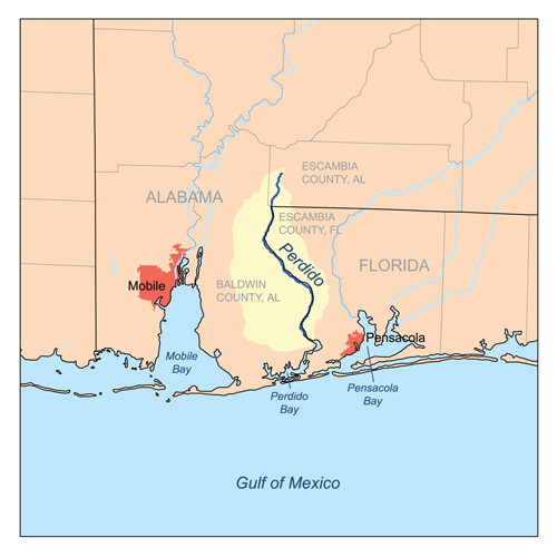
watershed = The Perdido River is a river in theU.S. state s ofAlabama andFlorida , approximately 60 miles (100 km) long. The river forms part of the boundary between the two states along nearly its entire length and drains into theGulf of Mexico . During the early 19th century it played a central role in a series of rotating boundary changes and disputes amongFrance ,Spain , Great Britain, and the United States.It rises in southeastern Alabama in Escambia County approximately 8 miles (11 km) NW of Atmore. It flows south approximately 5 miles (8 km) to
latitude 31°N, south of which it forms the remainder of the Alabama/Florida border. It flows generally ESE in a winding course and enters the north endPerdido Bay on the Gulf of Mexico approximately 10 miles (15 km) west ofPensacola, Florida .The word "perdido" is Spanish for "lost".
History
From 1682 to 1763 the Perdido formed the boundary between the French colony of
Louisiana and the Spanish colony of Florida. Following the British victory over the French in theFrench and Indian War , the United Kingdom received theFrench colonial territory west of the Perdido, as well as the Spanish colony of Florida, while Spain received the French territory west of theMississippi River . The British divided the new territory intoWest Florida andEast Florida at theApalachicola River (whose maintributary theChattahoochee River forms a large portion of the present boundary between Alabama and Georgia, and a small part of the Florida/Georgia boundary). In 1783, as part of the Treaty of Paris, Britain returned all of Florida to Spain, which at the time controlled all of the coast of the Gulf of Mexico.In 1800 as part of the Treaty of San Ildefonso, Spain returned Louisiana to France, retaining control of the territory east of the Mississippi as Florida. In 1804 France subsequently sold Louisiana to the U.S. in the
Louisiana Purchase . A boundary dispute erupted between the U.S. and Spain, with the U.S. claiming the land west of the Perdido as part of the original French territory of Louisiana, whereas the Spanish claimed that only the portion of Louisiana west of the Mississippi had been returned to France. The Gulf Coast south of 31 degrees latitude between the Mississippi and Perdido remained disputed between the two nations. The dispute was finally resolved in 1819 in theAdams-Onís Treaty , in which Spain ceded all of Florida to the United States. The Perdido became the boundary of theFlorida Territory in 1822.External links
*Gnis|288720|Perdido River
Wikimedia Foundation. 2010.